Trails for everyone, forever

Home Go Hiking Hiking Guide Hall Mountain

Hall Mountain

Eastern Washington > Selkirk Range
48.8075, -117.2584 Map & Directions
Length
14.0 miles, roundtrip
Elevation Gain
4,130 feet
Highest Point
6,323 feet
Calculated Difficulty About Calculated Difficulty
Hard
  • Wildflowers/Meadows
  • Mountain views
  • Wildlife
  • Established campsites
  • Summits
  • Dogs allowed on leash
  • Fall foliage

Climb, climb, climb through several stages of eastern forest to open wildflower filled alpine meadows and inspired views on this abandoned lookout peak. Continue reading

Rating
3.38 out of 5

(8 votes) Log in to rate

Hiking Hall Mountain

Climb, climb, climb through several stages of eastern forest to open wildflower filled alpine meadows and inspired views on this abandoned lookout peak.

Start on the Noisy Creek Trail, just off the main road to Sullivan Lake and adjacent to the Noisy Creek Campground, and begin the long, steady ascent up the mountain. The trail works its way through aspen and paper birch forests, providing an occasional view of Sullivan Lake below, before it enters a more densely forested section along Noisy Creek. The trail crosses Noisy Creek at approximately 2 miles; this is a rock hop late in the season, but can be a difficult crossing during spring runoff.

After the crossing, the route becomes steeper. Near 3.5 miles, the trail leaves Noisy Creek, so be sure to top off your water bottles—there’s no water source from this point on. The dry section of trail transitions into pine forest until the junction with the Hall Mountain Trail at the 5-mile mark. The Hall Mountain Trail continues to—you guessed it—climb steadily, gradually giving way to meadows of lush grass and wildflowers. Watch for lupine, Indian paintbrush, aster, flax, fireweed and sagebrush.

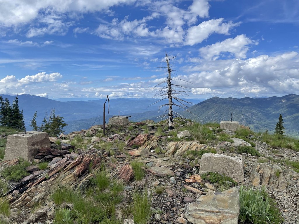
Just before the summit, Sullivan Lake comes into view once more, this time far, far below. From the top, you can imagine what the view from the lookout tower must have been like. Originally installed in 1930, the 10-foot tower was destroyed in the 1950s. Only the concrete base remains. Looking west, pick out the profiles of Abercrombie and Hooknose Mountains; to the north, Sullivan Mountain Lookout is visible, as well as Crowell Ridge; and to the east, the entire Shedroof Divide is in the foreground, with Idaho’s Selkirks off in the distance.

WTA worked here in 2011!

Hike Description Written by
Holly Weiler, WTA Correspondent

Hall Mountain

Map & Directions

Trailhead
Co-ordinates: 48.8075, -117.2584 Open in Google Maps

Before You Go

See weather forecast

WTA Pro Tip: Save a copy of our directions before you leave! App-based driving directions aren't always accurate and data connections may be unreliable as you drive to the trailhead.

Getting There

From Spokane, take US 2 north past Pend Oreille County Park. Turn onto
SR 211 north to Usk, then north on SR 20 to Tiger. Turn right on Sullivan Lake Road just before Ione. Look for the Noisy Creek Campground and trailhead at the south end of Sullivan Lake.

More Hike Details

Trailhead

Eastern Washington > Selkirk Range

Hall Mountain (#540)

Colville National Forest

Guidebooks & Maps

Day Hiking Eastern Washington by Rich Landers and Craig Romano

100 Hikes in the Inland Northwest by Rich Landers

50 Hikes for Eastern Washington's Highest Mountains by James P. Johnson

USGS Metaline Falls

You can improve or add to this guidebook entry

Hall Mountain

26 Trip Reports

Hiked here recently?

Submit a trip report!
 
Trip Reports