

Created in partnership between Snohomish Country Parks and Friends of Heybrook Ridge, and laid out and built by WTA volunteers, this short, moderately steep hike will take you through a rocky, moss covered forest to an incredible view of nearby peaks. Volunteers have also worked on building the Erinswood trail, which is adjacent to the Heybrook Ridge trail.
From the parking area, follow the main trail southeast through a stand of alder and big leaf maple 0.1 mile before reaching a junction. Follow signs to the right for the Leovy Trail, heading southwest. The first landmark is an immediate crossing of a shallow stream. Once you are across, the elevation gain starts. Switchbacks carry you 770 feet upwards through the next 1.4 miles, as you depart deciduous forest in favor of second-growth Douglas firs, Western hemlocks, and western redcedars that carpet the sides of the rock wall beneath Heybrook Ridge. Groundcover includes sword and deer ferns, thimbleberry, salmonberry, vine maple, and Cascade-Oregon grape.
Finely crafted rock steps, switchbacks, and turnpikes are a testament to the work of WTA volunteers who created a trail that resists the heavy rainfall of the area. 0.75 miles into the trail there is a bench resting point, with a view of small waterfalls formed by the creek that tumbles down the side of the ridge.
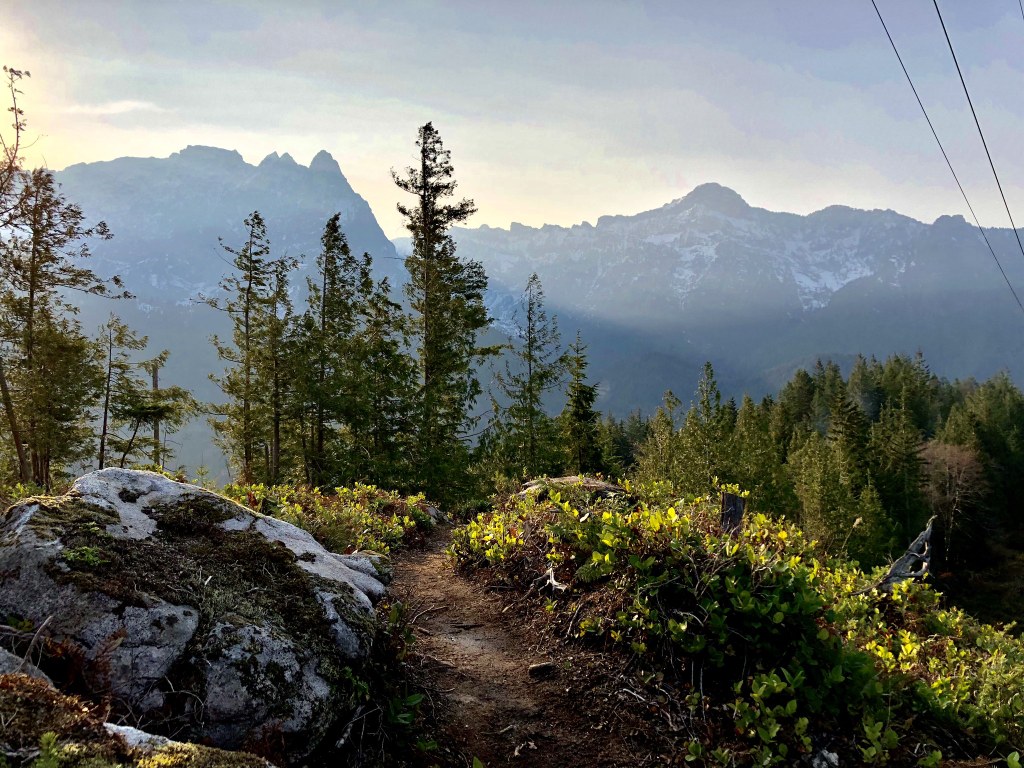
Periodically there are stretches where the trail flattens out and passes through stands of alder. 1.5 miles from the junction, cross an old logging road and climb to the ridgeline, passing under powerlines that trace the spine of Heybrook Ridge.
Descend briefly, and just beyond the 1.66 mile marker is a rocky outcrop on the north shoulder of the ridge. The South Fork Skykomish Valley is spread out below you. On clear days, Baring Mountain stands to the east, and Philadelphia Mountain is directly across the valley. Just to the west of Philadelphia are Mount Index and Bridal Veil Falls. Take in the view and appreciate the efforts of the Friends of Heybrook Ridge.
Once you reach the top of your elevation gain, you’ll have to cross a utility road and series of power lines before you hit the main viewpoint. On a clear day, you’ll be rewarded with a remarkable view of Mt. Index, Bridal Veil Falls, and the Skykomish valley.
Historic Note: Friends of Heybrook Ridge (FOHR) came together in 2007 to save 135 acres of forest from clear-cut logging. The volunteers raised money to buy the land, which was donated to become a Snohomish County park in 2008. The purchase of the land was ensured by a $500,000 gift from an anonymous benefactor, later revealed to be Dr. Conway Leovy, a founding member of FOHR and a professor of atmospheric sciences at the University of Washington. Leovy died in 2011 and intended Heybrook Ridge County Park to be his legacy.
WTA Pro Tip: When it is open for hiking, explore the adjoining ADA-accessible Erinswood trail for a peaceful woodland immersion experience.

 Trailhead


