

After crossing Steven’s Canyon Road from the Box Canyon Comfort Station parking lot, the signed Wonderland Trail is easily recognizable; bear right to start your journey heading towards Nickel Creek and Indian Bar. Although you’ll be heading uphill right away, the incline is not particularly steep, allowing a gradual warm-up through a lovely, shaded forest.
In a little less than a mile, you’ll arrive at Nickel Creek, your last reliable water source until you arrive at Indian Bar. A short distance beyond, find the junction announcing your arrival at the camp, which once housed a shelter, but is now home only to a handful of private backcountry campsites situated just above the creek.
Beyond Nickel Creek Camp, climb steadily for the next 1.75 miles through dense forest until you reach the Cowlitz Divide trail junction that leads to Olallie Creek Camp. Stay left to continue on the Wonderland Trail. Although there are no views during this section of the hike, be sure to look up every once in a while and marvel at the towering green canopy above you.
In another half mile or so, the forest begins to open up in the first of a series of small meadows which, in late summer, are prolific in producing berries for the picking. Where there are berries, there are bears, so — as always — while traveling the backcountry, remain vigilant of your surroundings, and don’t be afraid to make some noise (and to pick berries until your hands are stained blue). Another half mile of steep climbing will give you reason to pause and turn around to enjoy your first glimpse of Mount Adams and some peaks of the Goat Rocks Wilderness.
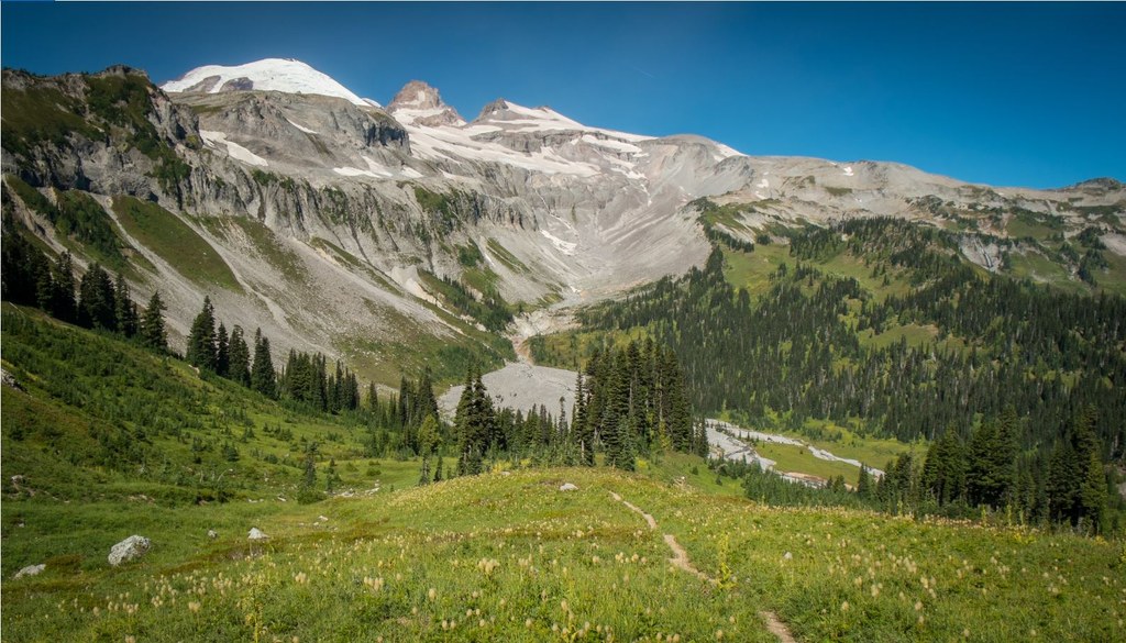
At this point, the trail begins to roll up and down — sometimes quite steeply — alternating between meadow and forest for the next two miles, until it finally breaks out of the trees and you are awarded your first real view of Mount Rainier in all of her glory. A bit more climbing, and you reach the high point of the trail, at approximately 5,900 feet, where — in peak season — you’ll be enveloped in fields of lupine, paintbrush, bistort, alpine daisies and corn lilies, surrounded in their entirety by extensive alpine views.
If time is not on your side, and you don’t feel like descending the roughly 800 feet to Indian Bar, this is a perfectly respectable (and absolutely stunning) place to pause… lounge… breathe in the mountain air… and watch butterflies and birds swoop and sway in the breeze. However, by pushing on just a little bit further, you can determine for yourself what all the fuss is about at Indian Bar.
The descent into Indian Bar can really be summed up in two parts: The first, a steep, staired, 200-foot drop with geologically-interesting exposed bedrock on either side of the trail, which eventually levels out just a bit and leads you around a corner to an absolutely jaw-dropping view of the bar, with its cascading waterfalls and extensive alpine meadows; next, the final push of your hike, which has you descending 600 feet through rolling wildflower-and-berry-strewn scenery.
While Mount Rainier will eventually become hidden by the ridges above you, you may not even notice, as Indian Bar itself is a sight to behold. Once at the bottom, you’ll immediately be greeted by a sign directing you to head left for the shade of the group shelter and a loo, or right to cross a picturesque bridge covering the rushing Wauhaukaupauken Falls to scout out one of the lovely, secluded, established backcountry campsites.
It’s worth noting that the Civilian Conservation Corps built the shelter at Indian Bar in 1940 under the supervision of Edwin A. Nickel (remember the creek you crossed at the beginning of this hike?), then-chief architect for the National Park Service Branch of Plans and Designs.
While this hike can be accomplished in one day by hardy hikers, the beauty of both the journey and the destination deserves much more of your time and attention. If possible, try to snag a backcountry camping permit from one of the park’s Wilderness Information Centers and gift yourself the luxury of staying overnight at Indian Bar, soaking your tired and weary feet in the Ohanapecosh River, feasting on the multitude of berries you’ve picked, and marveling at the beauty of the glacier-fed waterfalls and flower-filled meadows surrounding you.
Please note that this hike is only accessible from roughly mid-July through mid-September, weather and snow conditions permitting. Wildflowers typically are at their peak in late July and early August, while berries peak a few weeks after.

 Trailhead


