Trails for everyone, forever

Home Go Hiking Hiking Guide Ivanhoe Lake

Ivanhoe Lake

Snoqualmie Region > Snoqualmie Pass
47.4092, -121.1038 Map & Directions
Length
30.4 miles, roundtrip
Elevation Gain
3,279 feet
Highest Point
4,706 feet
Calculated Difficulty About Calculated Difficulty
Hard
Lake Ivanhoe on a sunny day. Photo by austineats.
  • Wildflowers/Meadows
  • Mountain views
  • Dogs allowed on leash
  • Ridges/passes
  • Lakes
  • Rivers

Tucked deep in the Okanogan-Wenatchee National Forest, Ivanhoe Lake is accessible via the Middle Fork Snoqualmie River Trail from the west or the Pacific Crest Trail and Dutch Miller Gap from the east side. Continue reading

Rating
0.00 out of 5

(0 votes) Log in to rate

Hiking Ivanhoe Lake

Tucked deep in the Okanogan-Wenatchee National Forest, Ivanhoe Lake is accessible via the Middle Fork Snoqualmie River Trail from the west or the Pacific Crest Trail and Dutch Miller Gap from the east side.

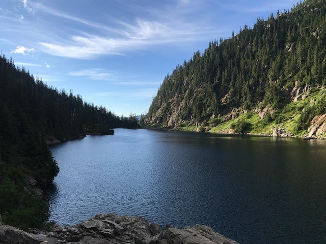
Set in bluffs and beautiful meadows, Lake Ivanhoe is a nice destination, but a difficult one to access. It's more than 14 miles from the Cathedral Pass or the Waptus River trailhead to the junction with the Pacific Crest Trail, and then another 3.8 to the lake's outlet. The data for this hike is given from the Waptus River trail starting at the Salmon Le Sac trailhead. 

A bridge 3.5 miles from the intersection of the Pacific Crest Trail has collapsed and made the trail past this point inaccessible to stock. There are no campfires allowed within half a mile of Lake Ivanhoe, and only two campsite options at the lake. There are a couple more sites available in the valley just before you arrive at the lake.

If you do decide to camp here please be aware of Leave No Trace principles and ensure you are camped on rock or dirt, not grass or flowers.

Toilet Information

  • Toilet at trailhead

More information about toilets

Hike Description Written by
Multiple authors contributed to this report, WTA Community

Ivanhoe Lake

Map & Directions

Trailhead
Co-ordinates: 47.4092, -121.1038 Open in Google Maps

Before You Go

See weather forecast

WTA Pro Tip: Save a copy of our directions before you leave! App-based driving directions aren't always accurate and data connections may be unreliable as you drive to the trailhead.

Getting There

Drive I-90 to exit 80 signed for Roslyn/Salmon la Sac. Turn north onto State Route 903. You’ll drive for nearly 15 miles, skirting Cle Elum Lake before arriving at a Y-junction in the road near the Salmon La Sac Campground. Veer left onto Road 111, crossing the bridge over the Cle Elum River and following the sign for the Cooper River Trail. Arrive at the large trailhead in another half mile.

You can get on the Waptus River trail from here a couple of ways. Either get on the Cooper River trail, then take the first right onto the Polallie Ridge trail, then one more right to the Waptus River Trail. Or, you can backtrack a bit down the road to a gated, rough road. This is the Waptus Bluffs trail. Hike the road for less than a quarter mile, then hang a left, heading uphill to connect with the Waptus River Trail.

More Hike Details

Trailhead

Snoqualmie Region > Snoqualmie Pass

Dutch Miller Gap (#1362), Pacific Crest Trail (#2000)

Okanogan-Wenatchee National Forest, Cle Elum Ranger District

You can improve or add to this guidebook entry

Ivanhoe Lake

22 Trip Reports

Hiked here recently?

Submit a trip report!
 
Trip Reports