Trails for everyone, forever

Home Go Hiking Hiking Guide Cathedral Rock

Cathedral Rock

Snoqualmie Region > Salmon La Sac/Teanaway
47.5435, -121.0970 Map & Directions
Length
8.0 miles, roundtrip
Elevation Gain
2,290 feet
Highest Point
5,550 feet
Calculated Difficulty About Calculated Difficulty
Moderate/Hard
Cathedral Rock. Photo by Jessica Wynne. Full-size image
  • Ridges/passes
  • Wildlife
  • Summits
  • Lakes
  • Wildflowers/Meadows
  • Mountain views
  • Dogs allowed on leash
  • Established campsites
  • Old growth
  • Fall foliage
Saved to My Backpack

While commonly used to access the Alpine Lakes backcountry, the trail up to Cathedral Pass is a worthy destination on its own. Old growth forest, lakes, subalpine meadows, and an up-close view of the dominating Cathedral Rock make for a satisfying and scenic day hike or short overnight. Continue reading

Rating
3.43 out of 5

(14 votes) Log in to rate

Hiking Cathedral Rock

While commonly used to access the Alpine Lakes backcountry, the trail up to Cathedral Pass is a worthy destination on its own. Old growth forest, lakes, subalpine meadows, and an up-close view of the dominating Cathedral Rock make for a satisfying and scenic day hike or short overnight.

Begin at the Cathedral Pass trailhead, at the sign for Cathedral Trail No. 1345, and follow the dirt trail into the forest. Reach a seasonal stream just beyond the meadow, then cross the bridge over the Cle Elum River. The forest quickly takes over, and the trail can be wet in the spring and fall. Cross into the Alpine Lakes Wilderness at 0.5 mile, and continue following the steady switchbacks up the hillside. In the late summer, ripe berries can be found the whole way up. 

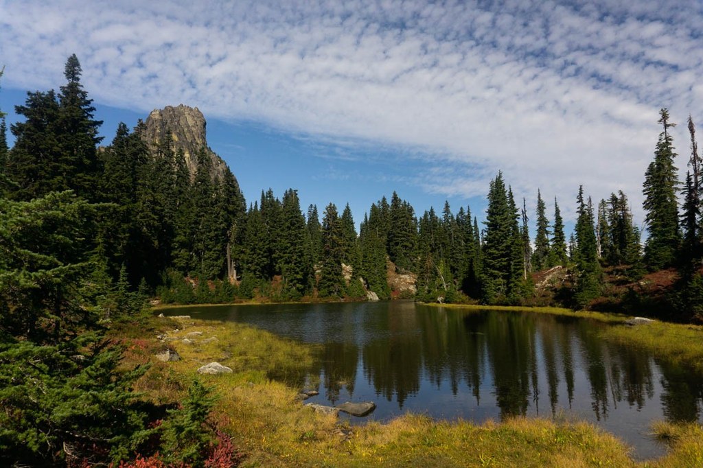
At 2 miles, continue straight at the junction with Trail Creek Trail 1332. The trail becomes steeper and rockier after the junction, but a short time later, arrive at a small lake at 2.5 miles. This lake is Squaw Lake. The word squaw is considered a derogatory and offensive slur by North American indigenous groups. WTA supports the ongoing efforts to rename the many geographical places that bear this name. 

The lake and has several established campsites located around it, including a designated horse camp on the north side of the lake. Follow the trail to the right and along the northeast shore of the lake.

Once away from the lake, the trail begins to climb again, steadily rising until you reach the meadow at about 3.25 miles. Take care sticking to durable surfaces throughout the meadow, and steer clear of areas signed for revegetation efforts. Flowers fill the meadow until fall, when the berry bushes turn fiery red. Mountain blueberries found up here are ripe into autumn, well after their lower elevation counterparts have faded.

The trail skirts a couple of small pretty lakes, but the real showstopper is the andesite tower of Cathedral Rock rising 1,084 feet above the ridge. While there are unmaintained paths that get a little closer to Cathedral Rock, rock climbing experience and gear are necessary to climb it. At 4 miles, the trail meets the Pacific Crest Trail at a signed junction. There is room to rest and enjoy the views before turning around and returning the way you came. 

WTA Pro Tip: From the junction with the PCT, continue west for just another tenth of a mile to catch some next-level views of Mount Daniel, Cathedral Rock, Deep Lake, and the mountain ranges to the west.

WTA worked here in 2016, 2015, 2014 and 2013!

Hike Description Written by
Jessica Wynne, WTA Correspondent

Cathedral Rock

Map & Directions

Trailhead
Co-ordinates: 47.5435, -121.0970 Open in Google Maps

Before You Go

See weather forecast

WTA Pro Tip: Save a copy of our directions before you leave! App-based driving directions aren't always accurate and data connections may be unreliable as you drive to the trailhead.

Getting There

From Seattle: Take I-90 east to exit 80 toward Roslyn/Suncadia. Turn left onto Bullfrog Road. Drive 2.1 miles, at the traffic circle, take the first exit to continue on Bullfrog Road. Drive another 0.7 miles, continue straight through the traffic circle onto WA-903 N.

From Ellensburg: Take I-90 west to exit 84 toward Cle Elum. Turn right onto Oakes Ave, follow for a 0.5 mile, then turn left onto W 2nd St/WA-903 N. Drive 2.2 miles and take the first exit at the traffic circle to stay on WA-903 N.

Continue through Roslyn, then turn left onto W Nevada Ave/WA-903 N. Follow the road right as it becomes N 7th St/WA-903 N. Continue for 14.8 miles until the end of the maintained road. Take a slight right onto Cle Elum Valley Rd/NF-4330. The rest of the drive is on a gravel road with varying conditions, and low clearance vehicles should use caution

More Hike Details

Trailhead

Snoqualmie Region > Salmon La Sac/Teanaway

Cathedral Pass Trail (#1345)

Okanogan-Wenatchee National Forest, Cle Elum Ranger District

Guidebooks & Maps

Day Hiking: Snoqualmie Pass (Nelson & Bauer - Mountaineers Books)

Alpine Lakes Wilderness: The Complete Hiking Guide (Nathan Barnes & Jeremy Barnes, Mountaineers Books)

You can improve or add to this guidebook entry!

Cathedral Rock

237 Trip Reports

Hiked here recently?

Submit a trip report!
 
Trip Reports