Trails for everyone, forever

Home Go Hiking Hiking Guide Kloochman Butte Trail

Kloochman Butte Trail

Southwest Washington > Columbia River Gorge - WA
45.7651, -122.3209 Map & Directions
Length
4.8 miles, roundtrip
Elevation Gain
1,340 feet
Highest Point
3,780 feet
Calculated Difficulty About Calculated Difficulty
Moderate
Views from the Kloochman Butte Trail. Photo by Ryan Ojerio. Full-size image
  • Fall foliage
  • Mountain views
  • Ridges/passes
  • Wildflowers/Meadows

Parking Pass/Entry Fee

Northwest Forest Pass
Saved to My Backpack

This route is a section of the Chinook Trail System, a yet-to-be-completed 300-mile bi-state loop encircling the Columbia River Gorge. The #180B section connects the Tarbell Trail to the Silver Star Trail. Many still refer to this section as the Kloochman Butte Trail. Continue reading

Rating
4.00 out of 5

Hiking Kloochman Butte Trail

Note: The previous name of this trail included the term “sq---” which is considered a derogatory and offensive slur by North American indigenous groups. WTA supports the ongoing efforts to rename the many geographical places that bear this name.

Known by locals as the Kloochman Butte Trail, Beginning at a junction with the Tarbell trail, the route follows an old road grade through young Douglas-fir forests then breaks out into meadows as it climbs a gentle ridge towards Silver Star Mountain.

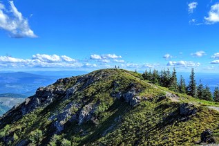
Some of the meadows near the upper trailhead at the junction with the Silver Star Trail are really beautiful and offer great views.

The first half-mile or so is on Washington Department of Natural Resource lands, then the remainder is administered by the Gifford Pinchot National Forest.

The trails is about 1.2 miles in length, however you can't drive to the trailhead, rather it is combined with a hike originating from a trailhead for the Tarbell Trail. There are several DNR Trailheads that provide access to the Tarbell Trail including the Tarbell Picnic Area, Rock Creek Campground and the Grouse Vista Trailhead.

Toilet Information

  • Toilet at trailhead

More information about toilets

WTA worked here in 2013!

Kloochman Butte Trail

Map & Directions

Trailhead
Co-ordinates: 45.7651, -122.3209 Open in Google Maps

Before You Go

See weather forecast

Parking Pass/Entry Fee

Northwest Forest Pass

WTA Pro Tip: Save a copy of our directions before you leave! App-based driving directions aren't always accurate and data connections may be unreliable as you drive to the trailhead.

Getting There

From Interstate 5 (traveling north or south) take Exit 11 and head east on Hwy 502/NE 219th St. toward Battle Ground. In 6 miles turn left on Hwy 503/NW 10th Avenue. Continue 5.6 miles and turn right on NE Rock Creek Rd. In 0.3 mile the road name changes to NE 152nd Avenue. In another 1.2 miles the road veers left and becomes NE Lucia Falls Rd.

About 8.2 miles after turning off Hwy 503 you'll pass Moulton Falls Park. In 0.3 mile after the park, turn right on NE Sunset Falls Rd. Continue 2.0 miles, then turn right (south) on NE Dole Valley Rd.

Drive for 5 miles to the Rock Creek Campground. Turn in here, following the one-way sign around past campsites to the day-use trailhead, complete with info kiosk and privy.

More Hike Details

Trailhead

Southwest Washington > Columbia River Gorge - WA

Chinook Trail (#180B)

Washington State Department of Natural Resources, Gifford Pinchot National Forest

Guidebooks & Maps

Green Trails Lookout Mtn No. 396

You can improve or add to this guidebook entry!

Kloochman Butte Trail

5 Trip Reports

Hiked here recently?

Submit a trip report!
 
Trip Reports