

This short, steep in places, route to Thorp Mountain has flowers, berries, and views along the way. The big payoff is the grand vista from the lookout, as befits its location as the highest point for many miles in all directions.
Of the different ways to get to Thorp Mountain, the Knox Creek Trail 1315A (formerly 1315.1) is the shortest at 2.2 miles one way. That's not to say it is the easiest. The trail characteristics are a steep start, a shallow middle, and a steep end. Be aware there are no water sources on this hike after the snow melts, so come prepared.
The trail starts by switchbacking up a steep flowered slope. In early summer, this is a waist-high flower garden, infringing upon, and obscuring the narrow trail. In places, one must lean into the brush and flowers, just to stay on the trail. After a rain, or heavy dew, hikers will be soaked from the waist down in the first 0.7 mile. This slope is also south facing, so mid-summer hikers will welcome any breeze to help cool the climb and will savor the few areas of shade on the climb.
After reaching the lower edge of the rocky ridge crest, the trail starts a climbing traverse, at times nearly straight up, as it traverses the head of the Knox Creek Basin to reach the Kachess Ridge crest at 1.2 miles, and the junction with the Kachess Ridge Trail, 1315. About 50 feet south of the junction is a viewpoint that overlooks the Knox Creek basin.
Go north on the Kachess Ridge Trail, enjoying a pleasant walk in the cool forest of old trees, and berries (in season) only losing and regaining 100 feet. At 1.3 miles, a short side trail leads to view of Thorp Lake, 600 feet below the trail.
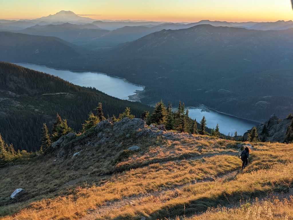
The forest walk ends as the trail crosses onto the wide open west side of Kachess Ridge at 1.7 miles, where Mount Rainier and Kachess Lake come into view. After another short climbing traverse through the flowers, the trail regains the crest at the junction with the Thorp Mountain Trail, 1315B (formerly 1315.2) at 1.9 miles.
There is a dry campsite at the junction and according to USFS sources, a spring about 0.3 mile on beyond the junction on the Kachess Ridge trail.
Take the Thorp Mountain Trail for a steep, 400 foot climb in 0.3 mile through the flowers and rocks, reaching the lookout at 2.2 miles from the trailhead.
The lookout, built in 1931, is not on a tower as none is necessary given its location. The lookout is open and manned by volunteers in the late summer and early fall. At other times, the lookout is locked, but the deck on the east and north sides are accessible.
The eastern view from the lookout deck includes Jolly Mountain, peaks of the Teanaway, Ingalls Peak, Mount Stuart, and peaks of the Stuart Range. To the north are Mounts Daniel and Hinman, while to the northwest are Summit Chief, Chimney Rock, and Lemah Mountain. From the ridgecrest just west of the lookout are southerly views of Mount Rainier and Mount Adams, while 3600 feet below is Kachess Lake, with its fishermen, boaters, and water skiers.
On a clear day, the time will fly as one enjoys the views and the local flowers. Binoculars or spotting scope are quite useful for the former.

 Trailhead


