

You'll get a good workout on this seven mile loop just outside of Spokane. Consider it for an early-season conditioner, or a way to get a lot of miles and elevation close to home all year round. In spring, it's a wildflower haven. Summertime can be hot, so bring plenty of water -- the river here is part of a natural area, so no swimming! If you visit in winter, note that it can get icy; be sure to bring traction devices.
You'll begin hiking at the Indian Painted Rocks Trailhead. Parallel the river, heading downstream for 1.7 miles on a flat-except-for-one-small-hill trail to link up with the true Knothead trail.
Begin climbing uphill from this junction on old road bed. You'll cross a road (which affords you your first big views) then a quarter mile later, bear right. This trail is new as of 2014 thanks to Washington Trails Association (WTA) volunteer work crews and other groups. Side trails may be evident here; please stay on the reroute, since the spur trails venture onto private property.
It climbs steeply from the road crossing. You'll mount several hills on your way -- one capped with forest, another that features WTA-built switchbacks, and a third which has a small trail that heads to an overlook of the lush Little Spokane River valley. Along this section, look for deer, both mule and whitetail. They like to browse in this sparse forest.
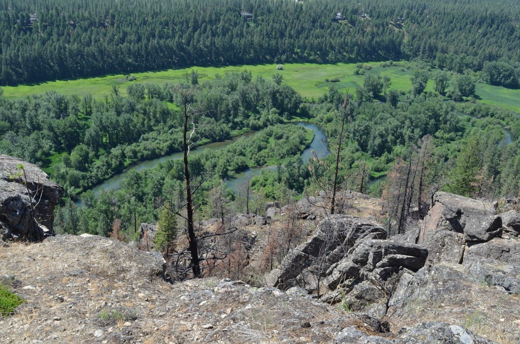
Take the spur trail for views. Eventually, it will loop back to the main trail further on, but for now it's a 1.5 mile out and back to the best views of the hike. From rocky outcroppings, you can see how the river loops around and back on itself, making this overlook a particularly picturesque stopping point. You might even spy kayakers in their colorful crafts plying the waters of the river below. Spokane and Mount Spokane are off to the left (northeast) and behind you, you might just make out the peaks of the Colville National Forest in the distance.
Back on the main trail, keep heading uphill to complete your loop. The trail gains just a bit more elevation before you arrive at a signpost indicating that you've come 2.3 miles from where you turned off the riverside trail. It's another 3 miles downhill, mostly on old roads. As you begin your descent, follow the old road around to a bench with views of Long Lake. Keep heading downhill, veering right onto a small section of WTA-built trail before rejoining the old road. At the base of the hillside, the road makes a 90 degree turn right and heads out of the Knothead Valley via a canyon. A human-caused fire here in 2015 charred a lot of this area, and the blackened trees and slow-to-return brush in the canyon are proof of how destructive human caused fire can be.
Soon, arrive at the Painted Rocks Trailhead. Go take a peek at the petroglyphs on a large rock behind a fence nearby, but remember that the paint on these rocks has historic significance. Refrain from adding your own.
WTA Pro Tip: Because this is a natural area, this hike is closed to dogs and mountain bikes. It's a great place to challenge yourself trail running!

 Trailhead


