
Mystic Lake is a charming emerald tarn nestled in a subalpine basin along the Wonderland Trail. A scenic saddle separates it from Moraine Park, an expansive mountain meadow threaded with gurgling brooks under the dome of Mount Rainier. Getting there requires first hiking or biking the 5 miles of closed Carbon River Road and then hiking to the Carbon Glacier. This route is longer than starting at Sunrise, but backpackers will appreciate the numerous streams and forest shade.
Start by following the Wonderland Trail uphill from the suspension bridge at the junction with the Spray Park Trail. The trail climbs through a boulder field below cliffs as the valley narrows and the Carbon Glacier comes into unobstructed view. The pristine white dome of Mount Rainier shines brilliantly above the blackened glacier’s terminus. A sign cautions curious hikers about the dangers of approaching the glacier, which can easily and safely be admired from the trail.
The trail then switchbacks steeply, traversing ledges and crossing a talus slope, before arriving at Dick Creek and Dick Creek Camp at 1.0 mile and 4100 feet. Although dark and viewless, Dick Creek Camp does boast ample space for 3 tents, a bear wire, and even a toilet. Continuing along the trail, Alaska cedar becomes abundant while mossy silver firs replace the Douglas firs. A view across the valley looks onto Echo Rock and a waterfall hanging below the meadows of Seattle Park.
Columbine, paintbrush, and beargrass begin to appear before the trail crosses beneath a mossy waterfall on a steep canyon wall. The forest now begins to open up, and between stands of subalpine fir and mountain hemlock lie slender meadows mixed with heather and huckleberry. At 2.0 miles and 5200 feet the trail crosses and then parallels Moraine Creek, which flows between two moraines of different ages. Views open more as the trail climbs beneath a boulder covered mountainside.
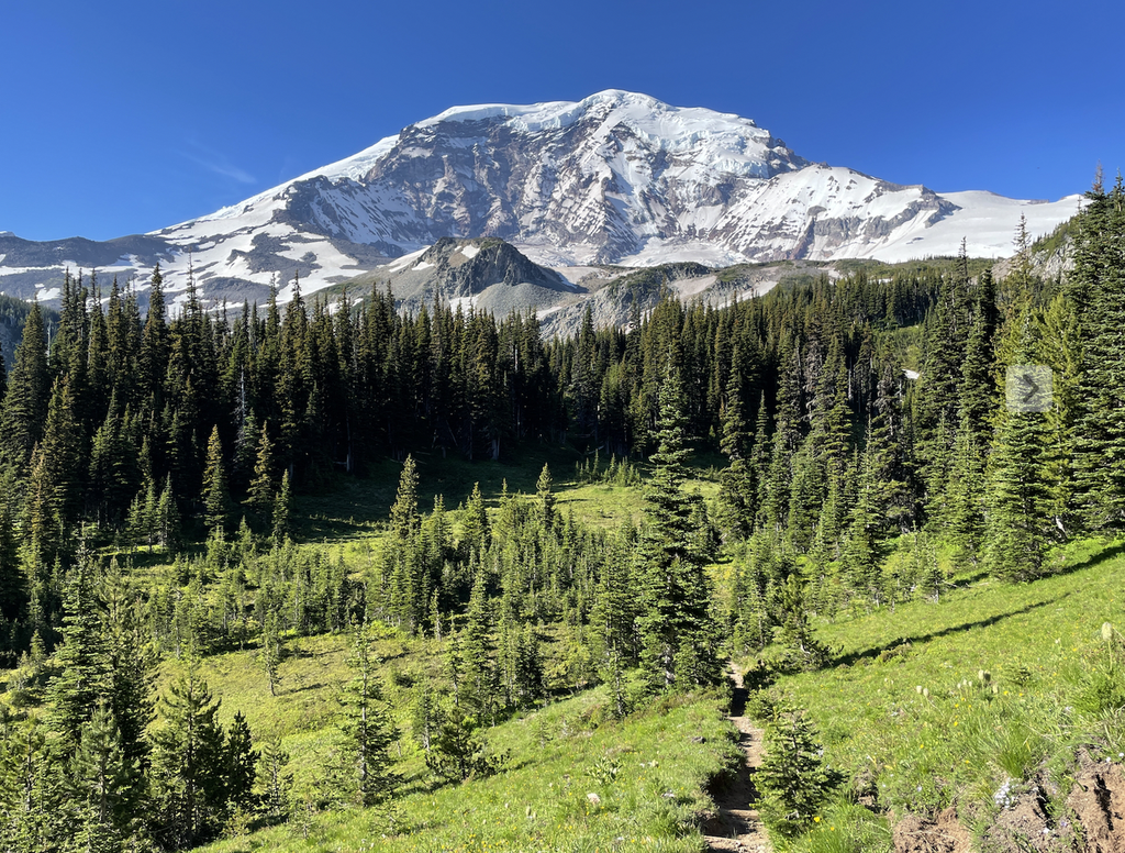
A gentler grade now follows the creek until a large, treeless meadow suddenly welcomes the hiker to Moraine Park at 2.8 miles and 5700 feet. The meadow is so large and flat that it would resemble Yellowstone if the ice-covered bulk of Mount Rainier wasn’t filling the entire background. Though it may be tempting to enter the meadow, please stay on the trail in order to preserve both the scenery and the delicate flora that takes so long to grow at this altitude.
At the far edge of the meadow the trail works its way uphill for the last time, switchbacking under cool, shady forest. The highest point of the hike is reached at a 6100 foot saddle that has a peekaboo view of an overused but healing tarn. The trail then steeply descends 400 feet through open forest with Mount Rainier still dominating the southern sky. At a grassy basin bottom lies Mystic Lake, and a boardwalk delivers the hiker to its shore at 4.2 miles and 5700 feet.
Mystic Lake is very shallow and its marshy fringe creates a haven for mosquitoes and is not suitable for swimming. Hikers may also lament the fact that Mineral Mountain almost entirely blocks the view of Mount Rainier from the lake. The midsummer bloom of beargrass and lupine in the meadow makes up for these shortcomings, though, and at night the backpacker may hear the hooting of owls or the crashing of ice in one of the most remote parts of the National Park.
Moraine Park - Mystic Lake

-
 Length
- 25.4 miles, roundtrip
-
 Elevation Gain
- 4,400 feet
-
 Highest Point
- 6,100 feet
The Fairfax Bridge (3 miles south of Carbonado) is closed to all vehicle and pedestrian traffic until further notice due to safety concerns. The bridge closure renders this hike inaccessible.
Parking Pass/Entry Fee
National Park PassPermits Required
Backcountry camping permit. Reserve online (fee)
Mystic Lake is a charming emerald tarn nestled in a subalpine basin along the Wonderland Trail. A scenic saddle separates it from Moraine Park, an expansive mountain meadow threaded with gurgling brooks under the dome of Mount Rainier. Getting there requires first hiking or biking the 5 miles of closed Carbon River Road and then hiking to the Carbon Glacier. This route is longer than starting at Sunrise, but backpackers will appreciate the numerous streams and forest shade.
Continue reading
Hiking Moraine Park - Mystic Lake
Map & Directions
 Trailhead
Before You Go
The Fairfax Bridge (3 miles south of Carbonado) is closed to all vehicle and pedestrian traffic until further notice due to safety concerns. The bridge closure renders this hike inaccessible.
Parking Pass/Entry Fee
National Park PassPermits Required
Backcountry camping permit. Reserve online (fee)WTA Pro Tip: Save a copy of our directions before you leave! App-based driving directions aren't always accurate and data connections may be unreliable as you drive to the trailhead.
Getting There
From Buckley, head south on Highway 165 for 1.6 miles. Turn left and stay on Highway 165, passing Wilkeson and crossing the the Carbon River Bridge before turning left toward Carbon River at 10.3 miles. Continue another 7.7 miles to the end of the road at Mount Rainier National Park, 18 miles from Buckley.
Parking for a dozen vehicles. Indoor toilets on the river side, opposite the Rainforest Loop trail. Carbon Glacier Trail starts after hiking or biking the 5 miles of abandoned Carbon River Road to Ipsut Creek Campground and then 3.5 miles along the Carbon Glacier Trail. Toilets, information board, and bike rails at trailhead.


