

Mount Aix is the 40th most prominent peak in Washington, with a prominence of 3296 feet (1005 meters). Its summit elevation is variously listed as 7,766, 7,759 or 7,770 feet. Regardless, it is the 33rd-highest peak in the state. The origin of the name Aix is unknown. Reportedly, an 1885 map showed it as "Mt. Aiks." The pronunciation is generally accepted to be "aches."(Insert your own joke here.) Taking advantage of the prominence, a lookout cabin occupied the summit from 1923 to 1961. Cables and minor construction debris are still present.
The trail starts out at 3,700 feet on a dusty path leading through moderately thick forest. At 0.3 mile is an easy stream crossing. In late summer, this is the only source of water along the trail. Make sure you are carrying enough for what lies ahead.
At 0.4 mile, the trail traverses to the south, at first level, and then gains ever more in steepness until beginning a series of switchbacks a half mile later. The switchbacks and traversing combine to take you through a steep-sloped forest, featuring numerous and diverse varieties of trees. See how many different types you can identify.
At 2.5 miles, the canopy begins to thin, and the shade lessens. Finally, one last long traverse takes you up to an exposed ridge at 7,150 feet, 4.4 miles. A weathered sign at a junction identifies the Nelson Ridge Trail #984 to the left. To the right and up continues the Mt. Aix Trail #982. Both of these trails connect to a third, the Richmond Mine Trail #983, as part of a 17-mile loop that stays above 4,400 feet. The loop gets little use, however, and may require routefinding skills.
Mount Aix is still hidden from sight. The peak visible a half mile to the north is the unnamed high point along the Nelson Ridge Trail. It affords a better view of Bumping Lake, and a clear view of the northwest side of Mount Aix. The trail is easy to follow, gaining 425 feet and losing 60 feet in 0.5 mile. The point at 7537 feet is a short 150-foot scramble off the trail.
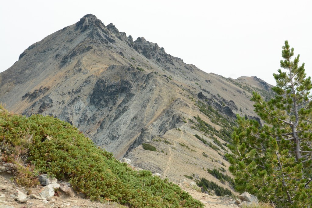
But that’s not why you’re here, is it? To get to Mount Aix, continue traversing uphill to the right. At 4.7 miles, the trail crests over a ridge and heads east, with your destination finally, gloriously, visible. Because of its southwest exposure, these upper elevations of the Mount Aix trail melt out earlier than other trails, leaving little more than rocks — talus, scree, rubble — call it what you want, you will want to watch your footing.
At 5.35 miles, you have a choice. A scramble trail heads sharply upward to the summit, gaining 300 feet in a mere eighth of a mile. The official route is another 0.65 mile, 5 times as long. The first half of it traverses a loose, rocky, and unstable slope, with small ups and downs, but no net gain or loss. The second half doubles back to the north, twisting and climbing up an exposed rocky rib, into a basin to the southeast of the summit, for the final push to the top.
Evaluate your choice based on your own skills and comfort level, and the conditions. If you choose the scramble, you will almost certainly want to use your hands at some point. Are you comfortable with that? Do you want to stash your trekking poles in your pack? If others are on the route, there is a significant risk of having loose rocks kicked down on you from above. On the official route, the biggest risk is ice on the steep slope, or if melted out, the tread itself, which suffers from loose rocks constantly sloughing downhill. Turning back is also an option; the peak along the Nelson Ridge Trail is a lot easier. (The mileage provided in this guide is for the longer, official trail to the summit, and back along the same route.)
From the summit, enjoy the aforementioned views. Look for mountain goats, identify peaks, or perhaps plan a future excursion from the perfect vantage point. Do you want to make the side trip to Nelson Ridge today, or save it for another trip?

 Trailhead


