

On this little used trail, hikers can see history, both natural and man-made. Large sections of the forest are recovering from the 2006 Tripod Complex Fire, and the two lookouts on the summit provide a glimpse of the 1920's and 1940's construction.
Starting from the trailhead at 3050 feet of elevation, the trail is on an abandoned road in the forest, which provides nice shade from afternoon heat for the first mile.
After one mile, at 3650 feet of elevation, the trail starts its climb through a recovering burn area of silver and black trees with low brush. This area also frequently has deadfall and some erosion, creating obstacles on the trail. On the plus side, deer are prevalent, feeding on the new growth. Bear are also evident. In May and early June, balsamroot, lupine, paintbrush, penstemon, and gilia are in bloom to 2 miles, 4450 feet of elevation.
In the lower burn area from mile 1 to mile 3.4, there is very little shade and no water after late May. In places, the trail can be obscured by the low brush and bare legs will have quite a few scratches at the end of the trip. Between 3.1 miles and 3.4 miles, Honeymoon Creek is nearby, but requires a 50 foot scramble down to it.
At 3.4 miles (5370 feet of elevation), the trail enters a forest that survived the fire and has a grassy understory. The forest shade is welcome as the trail steeply switchbacks up to 4.2 miles and 6030 feet of elevation before heading back onto the burned south slope of the 6813-foot elevation bump.
The trail has many short switchbacks as it climbs through the stark silver and black trunks before reaching the north side of the ridge at 5.2 miles and 6780 feet of elevation. The route has views to the south and southwest. This climb may be snowcovered and difficult to follow as late as April, so check trip reports or call the ranger station for a conditions report. If snow is still present, and you are confident in your navigational skills, head up on snow to the top of the bump. Until late May, the north side of the ridge may still be snowcovered for about 0.5 mile.
After passing the 6318-foot point, the trail descends slightly to a saddle at 6770 feet, before starting up the south ridge of North Twentymile Peak. At 5.7 miles, 6930 feet of elevation, the trail leaves the burn and continues to climb through the open, stunted forest nearly at the treeline. The views to the south are a prelude to the expansive views from the summit.
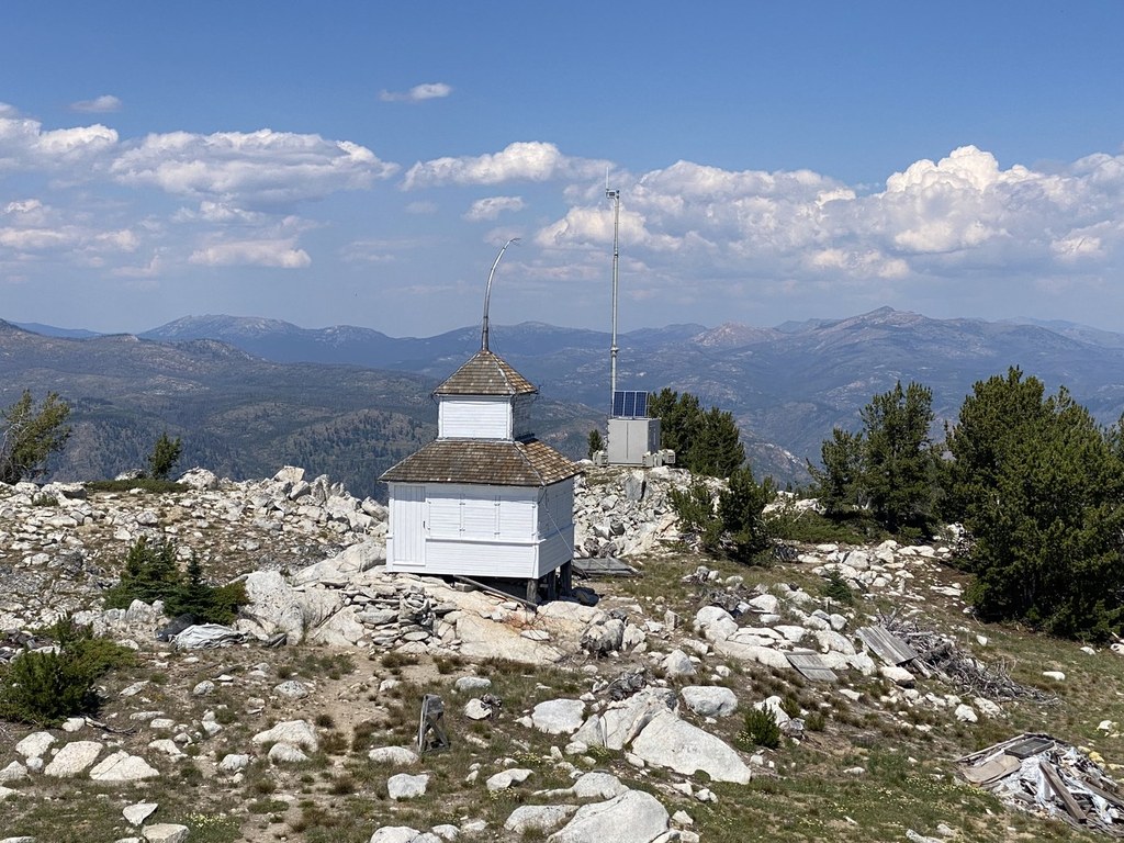
After a few short switchbacks, the 1940's lookout tower is reached and the 1920's lookout is short distance to the north. The summit area is an island of short alpine trees in a sea of recovering silver/black forest. The nearby views encompass the 2006 Tripod Complex which surrounds the peak, 2001 Thirtymile to the northeast, and 2003 Fawn Peak Complex to the west. The distant views include many prominent points: Remmel Mountain to the northwest, Windy Peak north-northeast, Tiffany Mountain to the southeast, and the Sawtooth Range directly south.
In 2016, the old lookout was under renovation, with lots of piles of new supplies and old construction debris (broken glass, old boards with nails). Be aware of where you step, and leave old artifacts for future visitors.
 Trailhead


