Trails for everyone, forever

Home Go Hiking Hiking Guide Old Mine Trail

Old Mine Trail

Mount Rainier Area > NW - Carbon River/Mowich
46.9832, -121.8381 Map & Directions
Length
3.4 miles, roundtrip
Elevation Gain
425 feet
Highest Point
2,150 feet
Calculated Difficulty About Calculated Difficulty
Easy/Moderate
The area around the old mine shaft. Photo by ilyanofi. Full-size image
  • Dogs not allowed
  • Good for kids
  • Fall foliage

Parking Pass/Entry Fee

National Park Pass
Saved to My Backpack

An infrequently-visited trail off the Carbon River Road, the Old Mine Trail follows a short but steep roadbed to a mineshaft. It's a good outing for kids, if they're willing to make the short push up the steep section. Continue reading

Rating
5.00 out of 5

(2 votes) Log in to rate

Hiking Old Mine Trail

An infrequently-visited trail off the Carbon River Road, the Old Mine Trail follows a short but steep roadbed to a mineshaft. It's a good outing for kids, if they're willing to make the short push up the steep section.

Just past the Carbon River Ranger Station, at the northwest entrance to Mount Rainier National Park, park your car and make your way down the flat, wide road converted to trail surrounded by greenery and the rushing of the river. After a bit more than a mile of hiking, look for a trail off to your right.


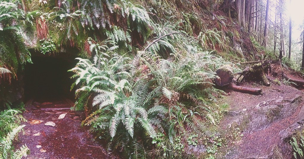
This is the route to the Old Mine, a steep push through close forests of Western Washington's signature western red cedar, Douglas fir, swordfern and fluffy moss. Luckily, the surroundings and the shortness of this uphill push make it bearable -- after just 0.3 miles you'll arrive at the mineshaft. 

A hole in the hillside framed with ferns, the mine entrance is gated about a hundred feet in, so kids and curious adults can explore a bit in relative safety. There are some beat-up tracks, marking the beginning of the carts' journey into the earth to extract ore. 

Look around the immediate area for other signs of human activity. Stumps and newer trees indicate areas that may have been cleared in the past as staging platforms for the exploratory mine activity.

WTA worked here in 2013!

Hike Description Written by
Multiple authors contributed to this report, WTA Community

Old Mine Trail

Map & Directions

Trailhead
Co-ordinates: 46.9832, -121.8381 Open in Google Maps

Before You Go

See weather forecast

Parking Pass/Entry Fee

National Park Pass

WTA Pro Tip: Save a copy of our directions before you leave! App-based driving directions aren't always accurate and data connections may be unreliable as you drive to the trailhead.

Getting There

From Puyallup, drive 13 miles east on State Route 410 to Buckley, then turn right onto SR 165. Proceed to the bridge over the Carbon River Gorge and then bear left to Mount Rainier National Park's Carbon River Entrance. Due to 2006 flood damage, it is now necessary to walk the road just inside the park boundary.

More Hike Details

Trailhead

Mount Rainier Area > NW - Carbon River/Mowich

Mount Rainier National Park

Guidebooks & Maps

Green Trails Mount Rainier National Park No 269S

You can improve or add to this guidebook entry!

Old Mine Trail

27 Trip Reports

Hiked here recently?

Submit a trip report!
 
Trip Reports