
The views from the trailhead are great, and just get better as hikers approach the Oregon Butte Lookout as the full expanse of the Wenaha-Tucannon Wilderness unfolds before them in a 360 degree radius.
The hike to the lookout is 6 miles roundtrip from the Teepee Trailhead. After 1 mile, the trail branches into lower and upper routes; the lower is more direct, shadier and newer. The higher route goes past West Butte, reconnects with the trail just before the spring. Bear right to the lookout at the junction with Trail 3113/6114, which is about .5 mile passed the tree trough spring. The lookout is still staffed in summer so be courteous when you get up there.
Oregon Butte

-
 Length
- 6.0 miles, roundtrip
-
 Elevation Gain
- 987 feet
-
 Highest Point
- 6,387 feet
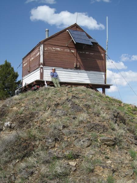
The most prominent peak in the Blue mountains, the views from the trailhead are great, and just get better as hikers approach the Oregon Butte Lookout as the full expanse of the Wenaha-Tucannon Wilderness unfolds before them in a 360 degree radius.
Continue reading
Parking Pass/Entry Fee
Northwest Forest PassHiking Oregon Butte
Oregon Butte
Map & Directions
 Trailhead
Before You Go
Parking Pass/Entry Fee
Northwest Forest PassWTA Pro Tip: Save a copy of our directions before you leave! App-based driving directions aren't always accurate and data connections may be unreliable as you drive to the trailhead.
Getting There
Take the Eckler Mountain Road from Dayton, WA. Follow the road for approximately 15 miles. There is a stone monument at a “Y” in the road marking the Kendall Skyline Road, turn right onto Kendall Skyline Road #46 and follow it for 12 miles toward the Godman Guard Station. Just below the Guard Station, turn left on Forest Service Road #4608. Take all main right turns for 5 miles to the Teepee Trailhead.


