

Looking for a challenge in route finding, with the payoff of partially obscured views? Then this trail is for you. What was once a popular non-motorized, multi-use trail was overrun by the 2006 Tripod Fire and the 2014 Carleton Complex Fire. Since the fires, a lack of maintenance and road washouts make access, routefinding, and traffic difficult here.
The trip to Pearrygin Peak, via the Pearrygin Creek trail is a much more difficult endeavor than it was in 2005. The trailhead has been moved down valley 0.7 miles by a massive road washout; evidence of the effects of fire removing vegetation and making soil more impervious to water.
During the spring melt a residual ice dam caused a stream backup and then when the dam broke, a flash flood created a 20-foot deep road washout. Subsequent erosion has made it deeper.
The partially obscured views from Pearrygin Peak are clearer now in the burned-out silver forest, but achieving those views becomes gradually more problematic as you hike in. The first scramble you negotiate is a quasi-stock trail that descends about 30 feet into the road washout and climb back out the other side. And that's nothing compared with what’s to come. At the trailhead, you’ll also observe a minor issue in travel – cow pies. Yes, this area is cattle grazing country.
After crossing the washout, a pleasant 0.7-mile forested road walk leads to the original trailhead. Enjoy pockets of flowers along the edges and kinnikinnik gradually encroaching over the road. The road is also a popular route with the animals. You may see cattle, coyote, bear, moose, and deer tracks, and droppings abound.
The next half-mile starts with a smaller washout crossing. At the bottom, go upstream about 30 feet to find the trail up out of the washout. It is followed by travel through smaller burn areas with the corresponding downed logs over the trail. The trail tread is readily located and travel is not too difficult, until the edge of the devastated forest is reached.
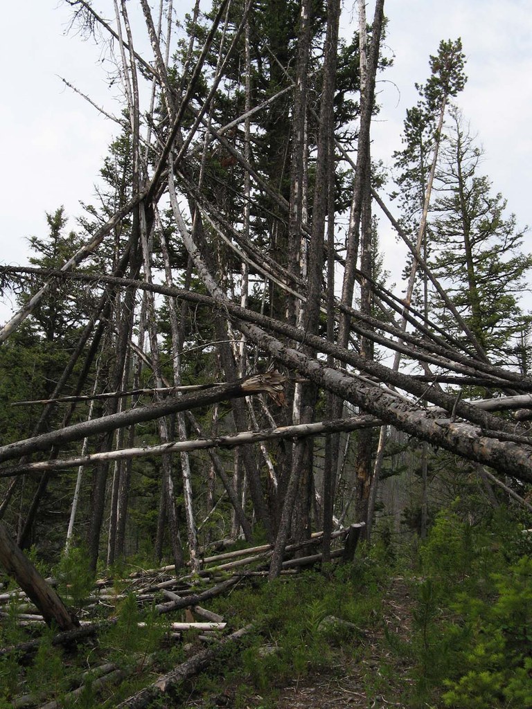
Once in the silver forest, the travel gets difficult with more logs over and above the trail. In addition, the natural reforestation of brushy young pines, along with the brush growth, obscures the trail tread.
In places, extended walks on the pick-up stick logs about 3 feet above the trail are the easiest mode of travel. This continues for 0.8 miles and reaches a blackened tree trunk with a white chainsaw blaze.
In 2019, locating the trail tread after this point became very difficult. A few cut logs, both pre-fire and post fire provided hints for the trail location. Tall brush will block views for significant stretches and a few open areas make easier travel and provide views of the valley up to the objective, Pearrygin Peak.
From the blazed tree, the trail starts a climbing traverse, it does not go down to the creek. After 0.4 mile come to a charred “6” sign on a silver tree that is still standing, another indication you are on the trail. From the “6” sign, the trail gradually climbs up the valley for 0.8 mile and reaches the north shoulder of Pearrygin Peak.
Now, only one half-mile of cross-country/boot trail travel is needed to finish (not much different than the prior 2.0 miles of “trail” travel). Only this time, there are more sections of surviving forest in the route that goes south along the ridge to the top. Once at the top, congratulations, you have crossed over 500 logs and pushed through hundreds of yards of brush getting to this point, assuming the trail has continued to be unmaintained. You probably have the scratches to prove it!
Enjoy the views, primarily to the south and east before returning to the trailhead. Did you remember to look back as you traveled in? The route out is about as difficult to find as the one going in!
WTA Pro Tip: A lower section of the Pearrygin Creek Trail, initially on the south side of the creek, is accessed from Road 7923 in the Methow Wildlife Area. The trail was damaged in a 2019 controlled burn that was more intensive than intended and killed most of the forest. A short section of trail reaches a ford of Pearrygin Creek and then the abandoned trail continues 3.5 miles to the east side of the 2019 trailhead (road washout).
 Trailhead


