

Start at the trailhead for Mount Dickerman. The Perry Creek trail leaves from the west end of the parking lot. The first mile is a mostly flat section that connects to an old road that leads a fifth of a mile to the former trailhead. At the occasional open spot along the way, enjoy views of Big Four Mountain’s north face and snowfields.
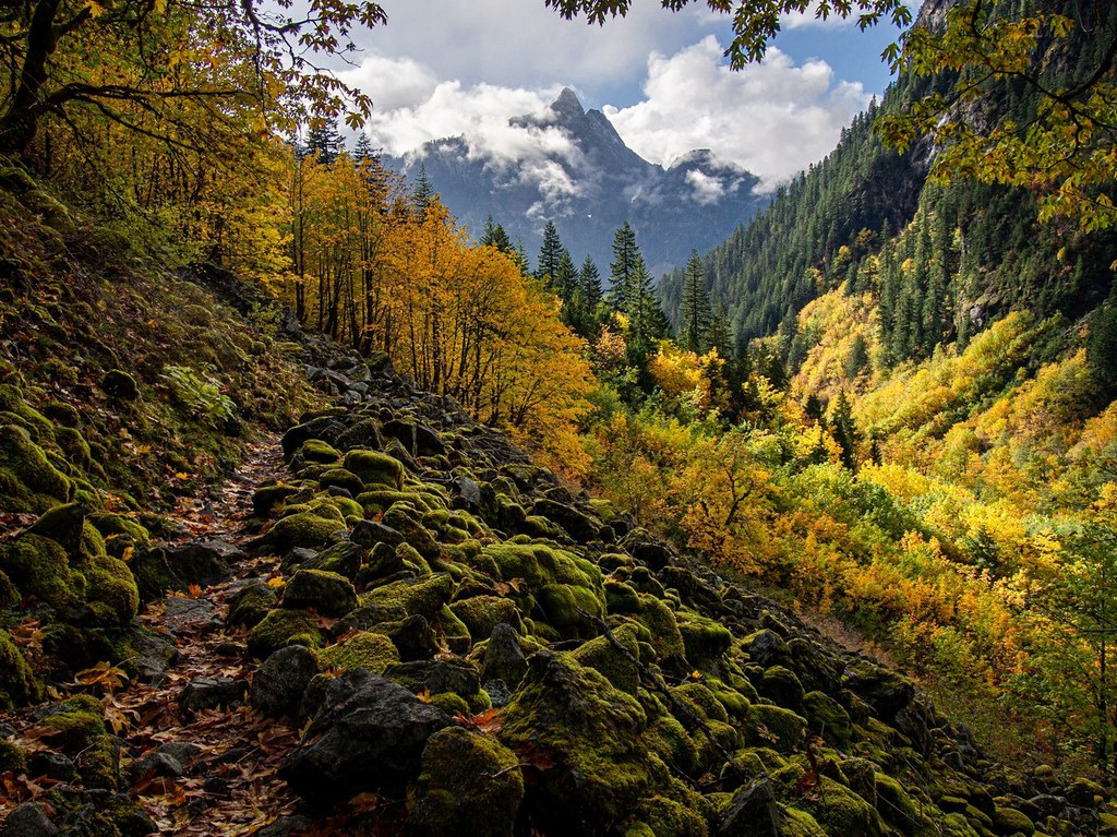
After a short stretch in dense forest, the trail breaks out into the open. From here, the same attributes that make the Perry Creek drainage so hospitable to so many different types of plants make it an awesome place to hike. The trail traverses the east side of the drainage, which is frequently intersected by talus slopes from the steep rock of Mount Dickerman overhead. These disturbed areas allow sunlight to reach hillsides that would otherwise be shaded by conifers, giving perennial plants a chance to flourish and providing hikers with views over the lush canopy below. On the far side of the creek, gaze upon waterfalls pouring down from green meadows on the upper slopes of Stillaguamish Peak. Where shade persists on the trail, abundant rain from the Puget Sound Convergence Zone carpets every available surface with thick moss. In places, ancient old-growth cedars rub shoulders with deciduous hardwoods.
To the untrained eye, all this may seem merely scenic, but there are some 250 different species of plant life here, many of them in the short distance below Perry Creek Falls. After years of lobbying by the Washington Native Plant Society and noted botanist Art Kruckeberg, the biodiversity found here led the Forest Service to set the area aside in 1997 as a research natural area. As wild as the environs of the entire Mountain Loop might feel, Perry Creek falls just outside of both the nearby Henry M. Jackson and Glacier Peak Wildernesses. The research natural area designation gives it something of a status even more protected than that of a wilderness — the Forest Service’s guidelines call for not encouraging recreational activities in a national research area, since the area is meant to be “unmodified.” Camping and fires, though not expressly prohibited in the Perry Creek area, are discouraged.
2 miles from the old trailhead, the trail reaches Perry Creek Falls, a tall rocky tumble of rushing whitewater. Unfortunately, much of the falls is hidden under a steep overhang; if you approach the edge for a look down, do so with great caution. For many, this makes a good destination in and of itself, but the trail continues on, crossing over Perry Creek a short distance above the falls. Past this overlook, there is no bridge, so be prepared to get your feet wet when the water is high, and turn around if you're uncomfortable. Head into old-growth forest on the west side of the gorge. Here, the way steepens as it switchbacks through the trees, gaining 2,000 feet in 2 miles.
A little over 1.5 miles from the creek crossing, the trail seems to branch off to the left. A short walk takes you to a saddle looking out at the deep valley between Stillaguamish Peak and Mount Forgotten. Some guidebooks identify this as Mount Forgotten Meadows, but it is in fact the beginning of a rough climber’s trail that heads off to Stillaguamish Peak. Return to the trail (or stay right all along) and in a third of a mile or so, reach the actual meadows, marked by a high point to the left and tarns to the right.
It may have been a long haul to get here, but the views are worth it. Across the tarns, look out to the meadow’s namesake, Mount Forgotten, to which a much rougher climbers’ trail continues. In fall, blueberries abound, attracting not only keen-eyed hikers but the occasional bear as well.
As you continue back, the greatest reward of all may still await: another chance to appreciate a place where sun, rain, and terrain converge to produce an incomparably rich explosion of life.
Please keep in mind to tread lightly here, and stay on the trail! In recognition of the incredible diversity of native plant life here — a stunning concentration of species rarely seen anywhere else in the Cascades — the entire area from the tip of Stillaguamish Peak to the summit of Mount Forgotten to the top of Mount Dickerman is a research natural area that could (in theory) be closed to all but scientific use. Thankfully, it's not, and hikers can enjoy the flora of this area.

 Trailhead


