Trails for everyone, forever

Home Go Hiking Hiking Guide Pomona Grange Park

Alert: On Oct. 1 the federal government began a partial shutdown that will impact National Parks, National Wildlife Refuges and U.S. Forest Service lands in Washington. Here's the latest information we have for hikers and campers


Pomona Grange Park

Puget Sound and Islands > Bellingham Area
48.5644, -122.3329 Map & Directions
Length
0.33 miles, roundtrip
Elevation Gain
10 feet
Highest Point
140 feet
Calculated Difficulty About Calculated Difficulty
Easy
A whimsical tree stump at the park. Photo by PJ Heusted. Full-size image
  • Dogs allowed on leash
  • Fall foliage
  • Good for kids
  • Rivers
  • Wildlife

Parking Pass/Entry Fee

None
Saved to My Backpack

Located just minutes off the freeway, Pomona Grange Park provides easy access to Friday Creek with excellent salmon viewing sites in the fall or a place to cool off during the heat of summer. With a wide, flat trail and room for a picnic, the park is an excellent place to stop with family and friends of all ages. Continue reading

Rating
0.00 out of 5

(0 votes) Log in to rate

Hiking Pomona Grange Park

Pomona Grange Park greets you with welcoming picnic spaces tucked away from the noise of the road and beneath a canopy of western red cedar. From the entrance, look to the right where a wide, dirt trail guides you further into the woods. As you wander along the trail, enjoy interpretive signs cluing you into the identity of the shrubs, ferns and trees that line the trail; although some of the trees have fallen since the signs were installed, the information they share helps to paint the picture of a healthy, riparian forest. 

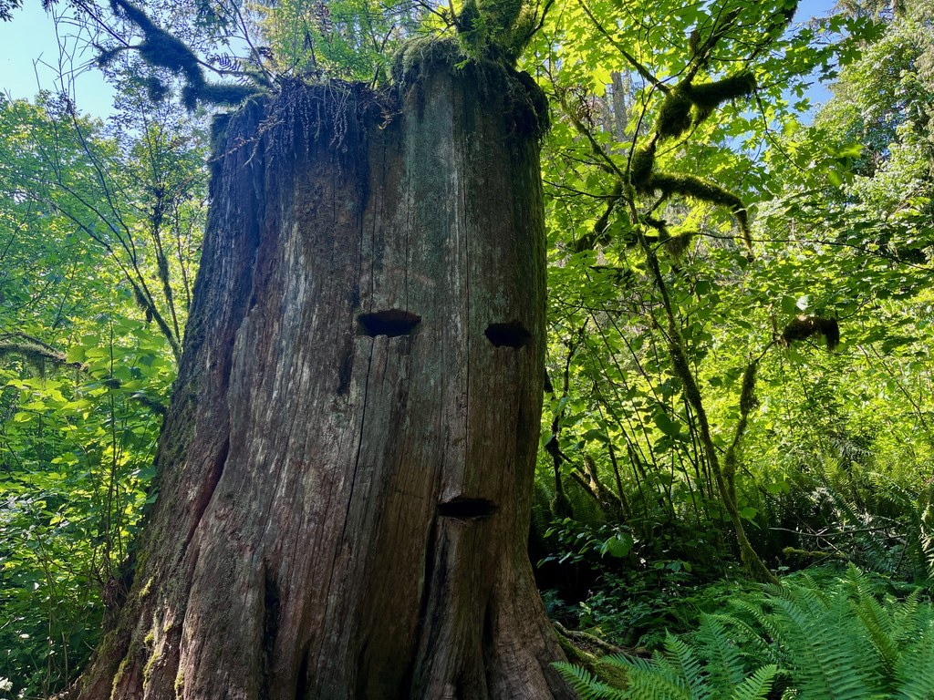
Continue walking the trail until about 0.2 mile, where you’ll hear the sounds of Friday Creek and find yourself greeted by a large cedar stump with what looks like a face carved into it, a remnant of the logging history that defined this region in the past. On the right is a raised wooden bridge crossing over to the creek itself. In the spring and summer, one can hop along rocks to reach the water itself or look for red-legged frogs and Pacific chorus frogs along the banks, while in the fall and early winter, the creek is full of spawning salmon making their way through the Samish watershed. 

Once you’ve enjoyed the creekside habitat — being sure to follow Leave No Trace principles and not stack rocks, take rocks or provoke wildlife — make your way back over the footbridge to the main trail itself. You’re now only about 0.1 mile from the parking and picnic area where you can 

From here, choose to either return to your car and carry on, or continue an additional 0.1 mile north towards the Samish Fish Hatchery for additional salmon viewing opportunities. 

Toilet Information

  • Toilet at trailhead

More information about toilets

WTA worked here in 2019!

Hike Description Written by
PJ Heusted, WTA Correspondent

Pomona Grange Park

Map & Directions

Trailhead
Co-ordinates: 48.5644, -122.3329 Open in Google Maps

Before You Go

See weather forecast

Parking Pass/Entry Fee

None

WTA Pro Tip: Save a copy of our directions before you leave! App-based driving directions aren't always accurate and data connections may be unreliable as you drive to the trailhead.

Getting There

From I-5, take exit 233 for Bow Hill Rd. Follow Bow Hill Rd for less than 0.25 mile until you reach the junction with Old Hwy 99. Turn left onto Old Hwy 99 and continue for 0.5 miles. Signage for Pomona Grange Park will be on the right-hand side of the road, as well as for the parking area. 

More Hike Details

Trailhead

Puget Sound and Islands > Bellingham Area

Skagit County Parks and Recreation

You can improve or add to this guidebook entry!

Pomona Grange Park

0 Trip Reports

Hiked here recently?

Submit a trip report!
 
There aren't any trip reports for this hike yet.