
If you’re looking for a thigh burner, Rattlesnake Ridge is your trail. With an elevation gain of 1806 feet in the first two miles, and another 372 feet in the next mile. The Rattlesnake Ridge trailhead is just off the Tucannon River Road, two miles past the Tucannon Guard Station. Parking just outside the Rattlesnake campground.
Begin by fording Panjab Creek, just behind campsite 1.
Once you’ve arrived at the other side of the ford, the fun really begins. Immediately begin climbing steeply up the hillside, switchbacking up an exposed, burned (2015) ridge; get an early start to avoid a direct, hot sun. WTA crews cleared the first mile of this trail in 2016, and the rest is clear and easy to follow.
The trail curves to the west side of the ridge, where balsamroot bask in the sun on the hillside. Keep climbing, and look also for lupine, paintbrush, desert parsley, and bitterroot as you go. Cross back to the east side of the ridgeline about a mile and a half from the trailhead, at your first peak -- 4776 feet.
Skirt another outcropping masquerading as your second high point. Now begins your first traverse – just below the top of a ridgeline looking southeast. After a bit of a breather, you’ll resume climbing, but this time a little more gently, to a broad open meadow, the intro to the second high point at 5748 feet.
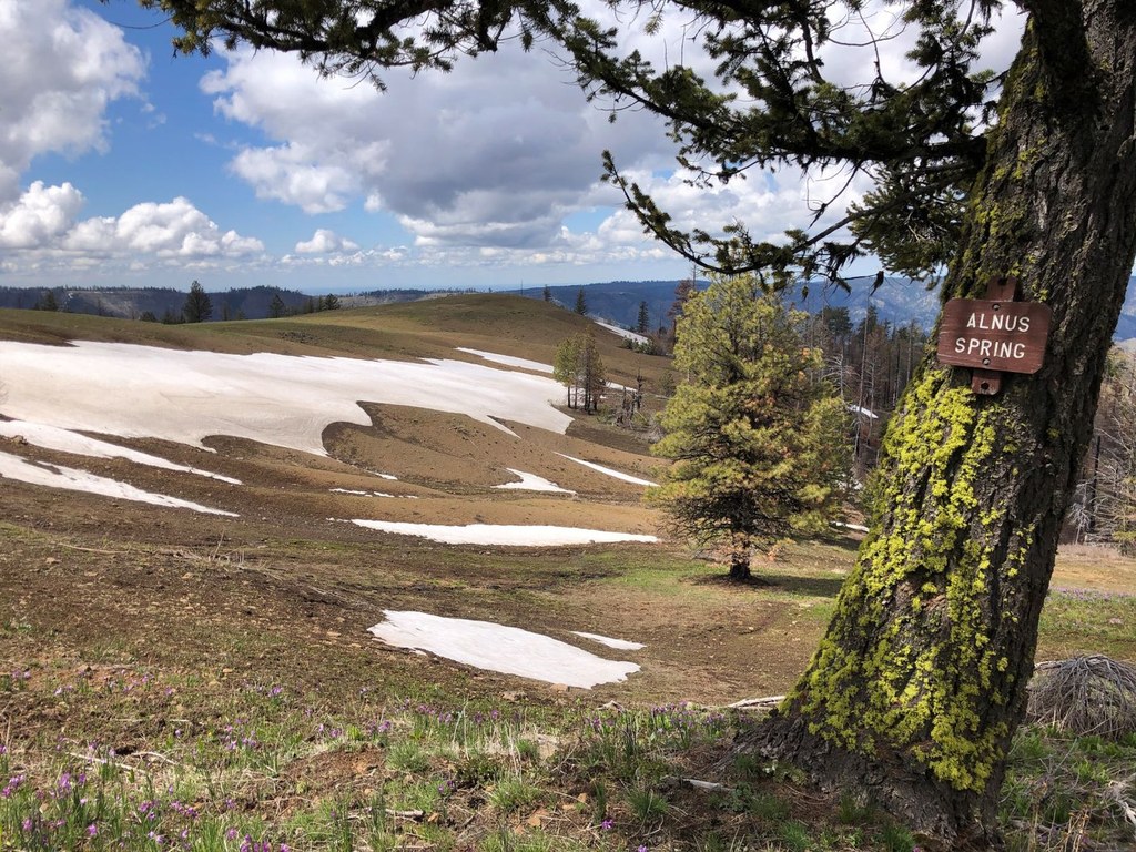
Skirt a small island of trees that shelters the high point, and follow the trail as it passes west to a point where it abruptly turns northeast and begins descending into a saddle. During this section, you may hear Alnus Spring burbling away, though it is out of sight, downhill from the trail
Past the spring, parkland opens up and glades of forest dot the landscape which is primarily wide open meadows full of Jacob’s shooting star, glacier lilies, and myriad other vibrant wildflower. Snow stays here for much longer, so the trail may be wet as the water runs off. But the traverse is gorgeous, with beautiful wildflowers and views of the Blue Mountains beyond.
Rattlesnake Ridge trail terminates about six miles from the trailhead, at an intersection in a meadow near Indian Corral. Taking a sharp right puts you on the 5.6 mille Panjab trail, which you can do in conjunction with Rattlesnake for a semi-loop (it requires a 2.1 mile road walk back to the Rattlesnake trailhead).
Continuing straight on at this junction is the Mount Misery Trail to Oregon Butte, and a left leads to trails 3113 and 3100 and campsites at Indian Corral. Take the right fork after dropping down the other side of the plateau (signs to Wehana River) to find Dunlap Springs If you're just hiking for the day, turn around at the junction or continue down the Panjab Trail. If you're continuing on, best of luck in your further adventures!
Rattlesnake Trail

-
 Length
- 12.0 miles, roundtrip
-
 Elevation Gain
- 2,700 feet
-
 Highest Point
- 5,700 feet
Parking Pass/Entry Fee
None
Located deep in the Wenaha-Tucannon wilderness, the Rattlesnake Trail promises wildflowers, expansive views, and even solitude. It's possible to do an out-and-back hike to Indian Corral, but many opt to do the loop with the Panjab Loop.
Continue reading
Hiking Rattlesnake Trail

WTA worked here in 2025, 2024, 2023, 2019 and 2018!
Map & Directions
 Trailhead
Before You Go
Parking Pass/Entry Fee
NoneWTA Pro Tip: Save a copy of our directions before you leave! App-based driving directions aren't always accurate and data connections may be unreliable as you drive to the trailhead.
Getting There
From Highway 12 13 miles north of Dayton or about 23 miles west of Pomeroy, turn south on the Tucannon River Road. Drive this road for 32 miles to a fork in the road. 30 miles in, the road becomes gravel. Take FR 4713 (the righthand fork) for a quarter mile, and look for the parking area, near the fish information board.
From Dayton, head northeast on Patit Road for 6.3 miles. Turn right onto Malcolm Grade Road and continue on this road for about 5 miles. Turn left onto Kendall Skyline Road and follow this road for 5.7 miles. About six miles from Malcolm Grade road, the road becomes FR 4620. Continue 2.4 miles and turn left to stay on NF 4620. Continue for a little more than a mile and then turn right on Tucannon Road. Continue 1.8 miles to a fork in the road, and take the right-hand branch. After about a quarter mile, the trailhead will be on the left, near the fish information board.


