
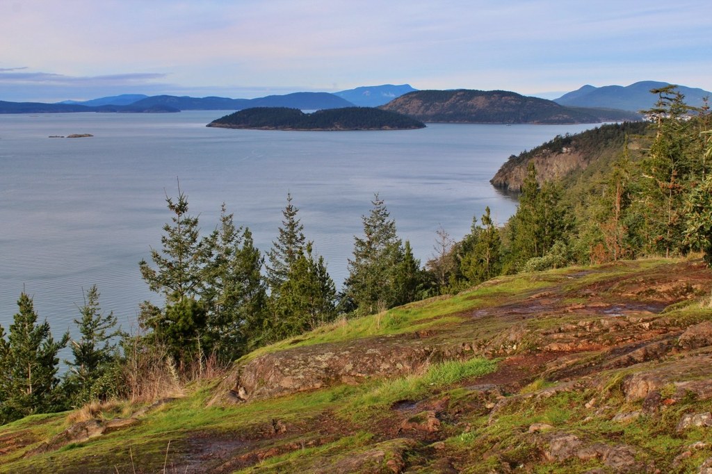

Follow well-signed but sometimes rough trails to a great viewpoint near the water's edge at Porpoise Point. Enjoy views of distant islands, and on a clear day of the distant Olympic Mountains. Sightings of seals, eagles, waterfowl, and sometimes otters are likely.
If you hiked these trails a few years ago, or have an older copy of a trail map, you need to be aware that trail names have changed, some trails have been rerouted, and new trails have been added.
You can download an excellent up-to-date map (pdf) before you go, or get a free paper copy at the trailhead, though they are not always stocked. Check the bulletin board next to the parking area and look for the small plastic box on the post at its left edge.
But as of summer 2019, a vintage bulletin board a few feet farther away from the parking area still has an older trail map posted on the back side. Ignore it. It's not helpful at all. Fortunately, every trail junction in the park has a sign post, and the trail names all agree with those on the new map.
Start out along the edge of the meadow on the Sares Head Trail. Continue on this WTA-built trail through a forested area and approach Fox Pond (actually, a beaver marsh.)
About 0.1 miles from the trailhead, a short spur trail to the right (Calypso Trail) just leads to a dead end. Check it out if you like but it doesn't offer much in the way of views.
You will find better views of Fox Pond as you continue on the Sares Head Trail. In late spring and summer the pond is choked with cattails and skunk cabbage. You may see a few areas of open water surrounded by lily pads and, in season, a few yellow lily flowers. As you hike past the pond be alert for ducks or a heron.
Continue on, and in another 0.3 miles pass junctions with the Porpoise Point Trail (on your right) and the Shelley Loop Trail (on your left.)
Continue on the Sares Head Trail and in about a quarter mile be alert for the Sunburst Trail on your right. Take that trail as it meanders generally downhill, with an occasional uphill section. Pass through forested areas with a lot of moss and lichens. Occasional openings offer views out to Rosario Straight and offshore islands. Short sections of the trail may be narrow or steep, so a trekking pole may be helpful for balance.
At the junction with the Madrone Trail a bench offers a rest stop, but it's not the best viewpoint. A bit farther along on the Sunburst Trail, turn left onto the signed Porpoise Point Trail that heads steeply downhill and is sometimes rather minimal.
Soon, reach a small flat area near the water's edge just off the main trail. It's worth spending some time here, enjoying the expansive views out to sea and the kelp beds near shore. Watch for occasional offshore appearances of porpoises, seals and otters, and for a variety of seabirds. And keep an eye aloft for eagles.
When you are ready, it's time for your return loop. Continue on the Porpoise Point Trail as it heads steeply back uphill, eventually reaching more level ground. Pass a junction with the Sunburst Trail, and in another 0.1 mi come to a junction with the oddly-named Calamity Trail. (That trail rejoins your ongoing Porpoise Point Trail in about a quarter mile, so you can explore it if you like. But it will add about 0.15 mi to your hike, with an additional 100 ft of elevation gain.)
As you approach the junction with the Madrone Trail, note the small four-foot-high gabled structure off the trail that looks like a small house, its purpose unknown.
Continue on the Porpoise Point Trail and, in another 0.1 mile, reach a junction with your incoming Sares Head Trail. Head left there to return to the parking area.
Extending Your Hike
Sharpe Park offers another great loop hike to a pair of viewpoints at Sares Head. For a more strenuous outing you could do both hikes in the same day.

 Trailhead


