Trails for everyone, forever

Home Go Hiking Hiking Guide Silver Shadow Loop
link

Silver Shadow Loop

Southwest Washington > Vancouver Area
45.7930, -122.3019 Map & Directions
Length
5.0 miles, one-way
Elevation Gain
500 feet
Highest Point
2,477 feet
Calculated Difficulty About Calculated Difficulty
Moderate
Signage on the Silver Shadow loop trail. Photo by Anna Roth. Full-size image
  • Wildflowers/Meadows
  • Mountain views
  • Dogs allowed on leash
  • Ridges/passes
  • Summits
  • Good for kids
  • Fall foliage

Parking Pass/Entry Fee

Discover Pass

This loop in Yacolt Burn State Forest makes for a lovely day hike with some great views of the forest and the lowland at the base of the forest. The 3-mile Silver Shadow connector makes this loop possible, and exists thanks to efforts from Washington Trails Association, Back Country Horsemen, Washington Conservation Corps, and DNR. Continue reading

Rating
0.00 out of 5

(0 votes) Log in to rate

Hiking Silver Shadow Loop

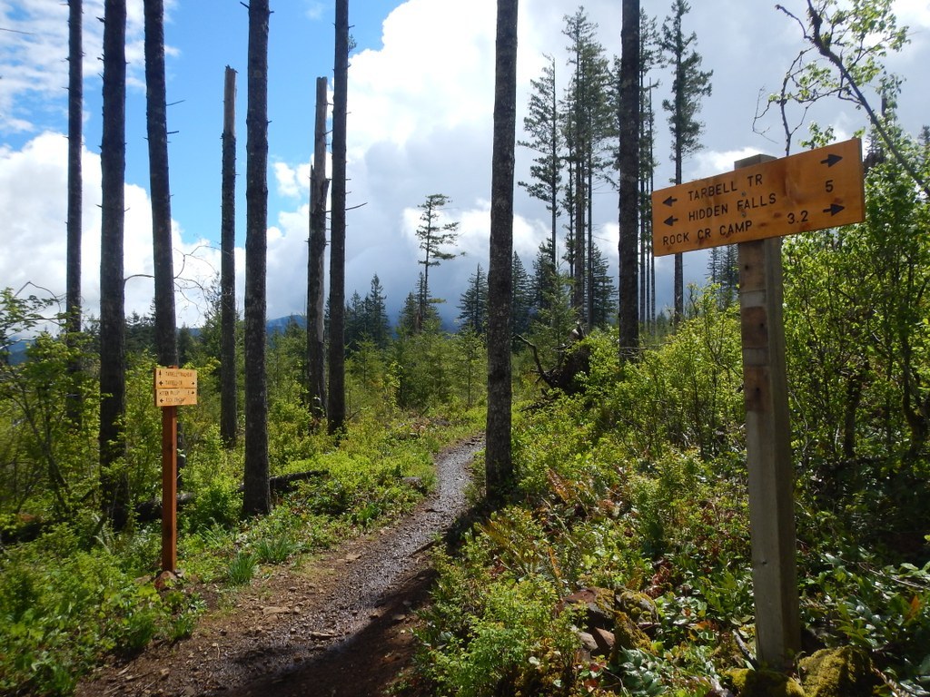
The trail begins at the Tarbell Trailhead Parking Lot and Picnic Site. One mile in on the Tarbell Trail is the beginning of The Silver Shadow Trail. At the end, the SS reconnects with the Tarbell to make a five-mile day hike easily done in 3 hours.  

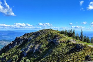
Heading clockwise on the Tarbell, the trail heads upwards near the top of Kloochman Bluff. At mile 1.1 on the Tarbell is the Silver Shadow Trail. Turn right onto the Silver Shadow Trail.

As you hike, you'll descends through a series of switchbacks to the base of the Kloochman where it rejoins the Tarbell Trail. Along the way, the hiker, biker, or horse rider is treated to a variety of Douglas Fir forests in various stages of growth - seedlings, saplings, mature trees.  

This is the Yacolt Burn State Forest and the Department of Natural Resources harvests trees for timber sales. Fortunately all of this area has been replanted. At the base of the SS trail, the Tarbell is rejoined where the hiker can head back to the Tarbell Trailhead 1.2 mile west or descend further along the fall line to Rock Creek Campground two miles away. 

WTA worked here in 2019, 2018 and 2017!

Silver Shadow Loop

Map & Directions

Trailhead
Co-ordinates: 45.7930, -122.3019 Open in Google Maps

Before You Go

See weather forecast

Parking Pass/Entry Fee

Discover Pass

WTA Pro Tip: Save a copy of our directions before you leave! App-based driving directions aren't always accurate and data connections may be unreliable as you drive to the trailhead.

Getting There

From I-5: take exit 11 for Battle Ground. Follow 219th St.(SR 502) east for about 6 miles. 219th becomes Main St. as you enter Battle Ground. At Battle Ground turn left (north) at the light signal onto SR 503 (Lewisville Highway). Follow SR 503 5.6 miles north past the Lewisville County Park then turn right at NE Rock Creek Road. (If you miss Rock Creek Road, then turn right at NE Beebe Road. It is the next right.)

The Tarbell trailhead is about 15 miles from the Rock Creek Road/SR 503 junction. Stay on Rock Creek Road and follow it south, it turns to the east and changes to Lucia Falls Road. Follow Lucia Falls Road past Moulton Falls County Park. You are now about 8 miles from the 503 jct. Just past the park turn right on NE Sunset Falls Road (Country Road 12.) and go 2 miles.

Turn right on Dole Valley Road/NE 312th Ave. and cross the bridge over the East Fork Lewis River. Follow Dole Valley Road for 2.4 miles. Now take a slight left onto a gravel road (L-1100). The L-1100 Road climbs through DNR timber harvest lands (keep an eye out for log trucks coming around the corners). In about 2 miles after leaving Dole Valley Road arrive at a large flat gravel area with a view to the east. The Tarbell Trailhead is on your right.

More Hike Details

Trailhead

Southwest Washington > Vancouver Area

Tarbell Trail (#), Silver Shadow (#)

Washington State Department of Natural Resources

Guidebooks & Maps

Yacolt Burn State Forest DNR PDF Map: https://bit.ly/2FyMm3q

Tarbell

Bells Mtn and Silver Star Trail Systems DNR PDF Map: https://bit.ly/2HckQLA

You can improve or add to this guidebook entry

Silver Shadow Loop

11 Trip Reports

Hiked here recently?

Submit a trip report!
 
Trip Reports