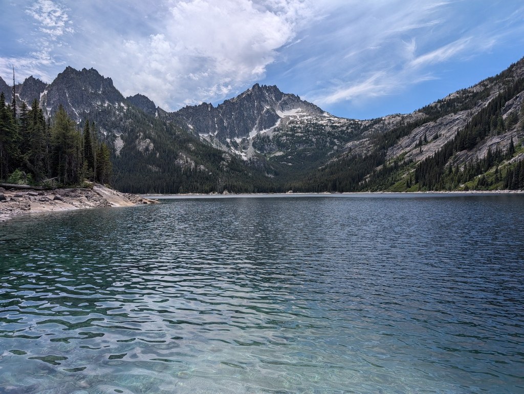

The Snow Lakes trail is known mostly as the long, gradual way into the Enchantments; but it is a worthwhile - if deceptively grueling - destination in its own right. The narrow isthmus between the lakes offers a majestic view across the water to the towering heights of McClellan Peak.
Camping at Snow Lakes or nearby Nada Lake used to be the strategy of backpackers who missed out on the Enchantment Lakes lottery but still wanted to get within easy day-hiking range of the permit zone. However, the permit zone has since been extended to include nearly the entire Snow Lakes trail from the top of the first set of switchbacks all the way around the far shore of the upper lake. As in the core Enchantment Zone, overnight stays within this area are allowed by special-issue permit only from May 15th - October 31st.
From its beginning just off of Icicle Creek Road, the trail immediately drops a short ways to a wide bridge over the creek and then begins climbing, gaining 800 feet in a set of lengthy switchbacks over its first mile. The grade levels off somewhat for the next mile and a half as you head straight back into the Snow Creek drainage, passing through terrain still bearing the sooty scars of a forest fire long ago. This early stretch of trail sees quite a bit of traffic from rock climbers making their way to Snow Creek Wall, the vertical face of granite visible on the far side of Snow Creek.
You soon enter forest and skirt the edges of the creek before the climbing begins in earnest again. Another set of switchbacks takes you through an area of trees snapped off impressively by slides and wind – you’ll pass several trees that bear sobering gashes from crashing boulders. After crossing a log bridge over Snow Creek, things once again level out, climbing slowly, but steadily until a steeper section over talus slopes takes you to Nada Lake under increasingly striking granite peaks.
It is not uncommon to see mountain goats as you make your way around the lake over a flat half mile and beyond. Here, the trail once again steepens as it passes through another rock field. Fortunately, the remaining distance has greatly shrunk by this point, and before you know it, you are at Snow Lakes.
The trail leads across a masonry spillway at the midpoint between the two lakes which, rugged and beautiful though they may be, are manmade. They are part of the Icicle Irrigation District, as is Colchuck Lake on the far side of the Enchantments. The water is drawn down in late summer not only to help farmers in the valleys below, but also to send much needed cold water to rearing salmon at the Leavenworth National Fish Hatchery. Hike through at the right time, and you may witness a huge plume of water shooting out over the rocks above Nada Lake from a massive tunnel bored to Snow Lake straight through the rock.
Depending on the season, the spillway may be dry or may be underwater. When the water is ankle high, hikers often remove their boots and socks and walk across barefoot to a small peninsula that juts out into the water, providing views up and down the lake.
In one direction is an impressive collection of bleached snags that have drifted down the lake and mounded up in impossibly large numbers. The upper end of the lake soars. Over the far shore, smooth slabs of granite curve gracefully towards the water’s edge while McClellan Peak towers above.
The trail continues from here around the lake and up into the Enchantments, but for day-hikers, this is the perfect spot to take in the views and turn around.
WTA Pro Tip #1: The hardest part of the Snow Lakes Trail is not the climb in, but the journey out. On the return to the trailhead, the trail sheds 3,600 feet of elevation over a rocky, uneven 5.3 miles between the outlet of Nada Lake and the bridge to the parking lot. Though seemingly not that steep, the uncommonly long downhill produces a constant jarring and pounding that reduces even hardened mountaineers to a pained shuffle by the time the parking lot comes into view – unfortunately, with 24 switchbacks still left to go. Leave yourself time to take breaks – no matter how used you are to long hikes, your feet will thank you.
WTA Pro Tip #2: For those camping, there are numerous spots around both Nada and Snow Lakes and along the trail. Pay attention to posted signs, though, as there are many places that are marked off-limits, such as those for day use only and those closed for restoration. There are lots of excellent spots tucked in the trees around Lower Snow Lake – a sign points off the main trail just before the spillway. There are also a few scattered sites along the early portion of the trail, at 2.5, 3.3, and 4.75 miles from the trailhead. The last one is situated just before a sign prohibiting campfires beyond that point. However, the scarred landscape below argues for relying on a camp stove even here. Remember that camping is by permit only at all of these sites from May 15th-October 31st.
WTA Pro Tip #3: In late summer, pack insect repellant. By July, the Snow Lakes are home to a large and particularly voracious population of mosquitoes, especially in the dark, cool forest along its southeastern shore.
Snow Lakes

-
 Length
- 14.0 miles, roundtrip
-
 Elevation Gain
- 4,300 feet
-
 Highest Point
- 5,500 feet
Parking Pass/Entry Fee
Northwest Forest Pass
The Snow Lakes trail is known mostly as the long, gradual way into the Enchantments; but it is a worthwhile - if deceptively grueling - destination in its own right. The narrow isthmus between the lakes offers a majestic view across the water to the towering heights of McClellan Peak.
Continue reading
Hiking Snow Lakes

WTA worked here in 2023, 2012, 2011, 2008 and 2005!
Snow Lakes
Map & Directions
 Trailhead
Before You Go
Dispersed camping is not allowed between FR 7601 and Icicle Creek.
Parking Pass/Entry Fee
Northwest Forest PassWTA Pro Tip: Save a copy of our directions before you leave! App-based driving directions aren't always accurate and data connections may be unreliable as you drive to the trailhead.


