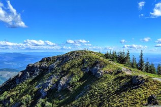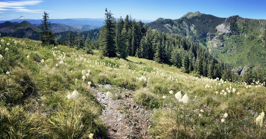

Steep is the name of Starway's game. You'll reach the summit in just 3 miles, but 2.5 of them feature a gain of almost 1,000 feet per mile! The trail may have been hard to find in years past, but as of 2025 is in very good shape. It's littered with wildflowers in the spring — bear grass, paintbrush, western sweet-vetch and more — and huckleberries in the fall. Once you arrive at the top, enjoy a 360-degree view that includes Mounts Adams, St. Helens, Hood, Jefferson and Rainier, as well as nearby Silver Star Mountain. On particularly clear days, you may even see the peaks of the Oregon Coast Range.
The primitive Starway trail was a slapdash job by its creator. The apocryphal tale is that after finding a mining claim back in the hills, the Starway trail's creator built a fast path up and over the nearest mountain to access it. As a result, the trail follows old road beds and the fall line of the hill in some sections, so it is one of the steepest ones you'll find in the state of Washington, on par with the Gorge's Mount Defiance.
Road maintenance in the Silver Star area has resulted in improved driving conditions to many trailheads. The road to Starway features a few steep sections of narrow road, so four-wheel drive is recommended, but in good conditions, probably not required. The parking area is small and unsigned, generally more of a pullout, so have your maps downloaded in advance. These things, along with the strenuous reputation of the hike, mean it's quite likely that you could be the only one on the trail.
From the trailhead, you'll start by heading downhill (adding to your total uphill gain over the short mileage to the high point) to Copper Creek where a bridge spans the stream. (Note: If the gate near the trailhead is open, you can drive down this first section of trail to a small parking area beside Copper Creek.) Cross the bridge and turn upstream (left). One-quarter mile past the bridge, the Starway Trail leaves the old roadbed and veers steeply to the right, nearly reversing direction. Follow this trail steeply up the ridge. You'll cross a small scree field and encounter a few switchbacks — though not nearly enough of them, for that would make Starway too easy. Instead, enjoy the burn in your calves and try not to think about what your knees will say on the way back down.
Eventually, you'll level out for a short while, entering into a more expansive-feeling forest, the ground covered in foam flowers. You'll start to see bear grass before climbing again, alternate forest with a few small meadows, and cross another scree area before winding around the east side of the high point (3,977 feet). If you're careful of the loose rock, you can scramble to the viewpoint here for 360-degree views and, on a clear day, sights of Helens, Rainier, Adams, Mt. Hood and more. To the southwest, you'll see the double-summit southern aspect of Silver Star Mountain. Straight west, you'll be able to pick out portions of the main Silver Star Trail and Ed's Trail, and straight south, you can make out the long ridgeline that carries the Bluff Mountain Trail east to Little Baldy.
After descending through a meadow and a bit more forest, you'll pop out along a viewpoint of the valley to the west. Here, if it's been wet enough, you'll get a glimpse of the tiered waterfalls in the Star Creek Valley. The trail continues to descend, becoming much more narrow than in the first few miles, but still obvious. The trail drops quickly through alternating huckleberry and beargrass-full meadows and forest to a saddle, then ascends to intersect the Bluff Mountain Trail 172 just east of Silver Star Mountain. While this last section is not difficult to find, it is a bit overgrown, and you will need to do some gentle wading through the plants — be prepared for a coating of yellow pollen if the bear grass is in bloom.
EXTENDING YOUR TRIP
From the intersection with Bluff Mountain, you can turn left and follow the ridgeline along the Bluff Mountain trail 2.5 miles to the Bluff Mountain summit, or turn right and bag Silver Star in a little over 1 mile.
 Trailhead