Trails for everyone, forever

Home Go Hiking Hiking Guide Thorp Lake
WTA is a nonprofit that needs you

We're just as excited as you to get the summer hiking season started. We're psyched our website, app and work for trails help you get outside.

But we're a nonprofit that runs on donations from regular people. If everyone who visited this site this holiday weekend donated $9/month, it would fully fund our work for the next 2 years. Time spent outdoors is priceless, but every donation large or small helps us support those experiences for everyone. Thank you and happy hiking!


Please take 2 minS to chip in $9

link

Thorp Lake

Snoqualmie Region > Salmon La Sac/Teanaway
47.3733, -121.1582 Map & Directions
Length
5.8 miles, roundtrip
Elevation Gain
1,260 feet
Highest Point
4,700 feet
Calculated Difficulty About Calculated Difficulty
Moderate
  • Mountain views
  • Lakes
  • Established campsites
  • Fall foliage

Parking Pass/Entry Fee

None
Saved to My Backpack

With a low-key walk that merges into a steep uphill climb, and an optional extension to visit a fire lookout, the trail to Thorp Lake offers a range of hiking experiences crammed into one 2.6-mile trail. Continue reading

Rating
4.17 out of 5

(12 votes) Log in to rate

Hiking Thorp Lake

With a low-key walk that merges into a steep uphill climb, and an optional extension to visit a fire lookout, the trail to Thorp Lake offers a range of hiking experiences crammed into one 2.6-mile trail.

Set off from the tiny trailhead, going around a gate and down to a creek crossing, just a few feet from the trailhead. Try to rock hop if you can here – it runs deep and salmon use the stream for habitat, no need to disturb them.

The roadbed continues on once you’re across Thorp Creek, leading to a rather large junction, signed for Little Joe Lake to the right, and Thorp Creek to the left. Hang a left, the trail is called Thorp Creek, but you’ll get to Thorp Lake this way. 

Climb up a now very-rough roadbed for less than a quarter-mile to where the roadbed is blocked by a large log. A trail takes off to the lefthand side of the road, occasionally marked by a bandanna. Even if the bandanna isn't there, it's not hard to see the junction. Duck down the left-hand trail, which retains its character (for the moment at least) as a rolling trail through open forest. Lined with huckleberries, you may want to allot some time here if you visit in fall.

After about a mile and a half more of gentle rolling, the trail gets down to it, by heading up. Sometimes switchbacking, sometimes simply climbing straight uphill, the route has changed from roadbed to old fisherman's trail, heading for Thorp Lake.

Occasionally, the switchbacks are interspersed with some longer traverses but on the whole, this part of the trail is a slog. Take your time. Along the way there are a few small trickles if you need to refill water or your four-legged hiking companion is thirsty.

2.4 miles from the trailhead, arrive at a junction. Whew! You’ve made it. The lake is a very gentle 0.2 miles ahead of you, through much of the same environs you’ve been in: pine trees dotted with aspens, huckleberries, and generally open forest.

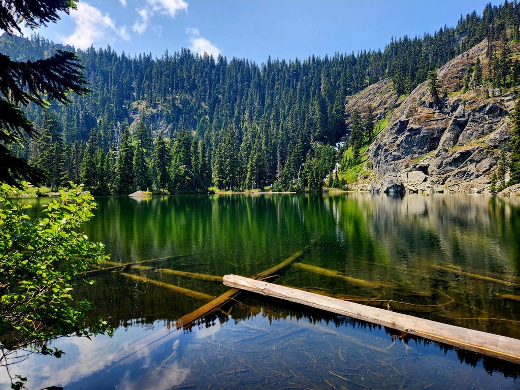
There are campsites at Thorp Lake, and you can see up to Thorp Mountain, though the lookout perched on top isn’t visible from the lake. You’ll have to save that one for later. Maybe a side trip during a campout here.

Hike Description Written by
Anna Roth, WTA Staff

Thorp Lake

Map & Directions

Trailhead
Co-ordinates: 47.3733, -121.1582 Open in Google Maps

Before You Go

See weather forecast

Parking Pass/Entry Fee

None

WTA Pro Tip: Save a copy of our directions before you leave! App-based driving directions aren't always accurate and data connections may be unreliable as you drive to the trailhead.

Getting There

Drive I-90 to exit 80 for Roslyn/Salmon La Sac. Turn north onto Bullfrog Road (crossing the freeway if coming from the west). Continue on this road through two roundabouts, following signs for 903.

Drive through the small town of Roslyn 13 miles from I-90, turn left onto paved French Cabin Road (Forest Road 4308). This road soon becomes gravel and washboarded - drive slowly.

It's a little more than 3 miles to a junction with FR 4312 on the right, signed for Knox Creek and Thorp Lake Trail. The sign says it's 3 miles to the Thorp Lake Trail, but it's actually just 1.5 miles to the parking area. There's only room for 2 or 3 cars here, so please park considerately, and be sure to not block the gate

More Hike Details

Trailhead

Snoqualmie Region > Salmon La Sac/Teanaway

Thorp Lake (#1316)

Okanogan-Wenatchee National Forest, Cle Elum Ranger District

Guidebooks & Maps

Day Hiking: Snoqualmie Region - 2nd ed (Nelson - Mountaineers Books)

Green Trails Kachess Lake No. 208

Buy the Green Trails Alpine Lakes East No. 208SX map

Buy the Green Trails Kachess Lake No. 208 map

You can improve or add to this guidebook entry!

Thorp Lake

107 Trip Reports

Hiked here recently?

Submit a trip report!
 
Trip Reports