Trails for everyone, forever

Home Go Hiking Hiking Guide Thunder Creek
WTA is a nonprofit that needs you

We're just as excited as you to get the summer hiking season started. We're psyched our website, app and work for trails help you get outside.

But we're a nonprofit that runs on donations from regular people. If everyone who visited this site this holiday weekend donated $9/month, it would fully fund our work for the next 2 years. Time spent outdoors is priceless, but every donation large or small helps us support those experiences for everyone. Thank you and happy hiking!


Please take 2 minS to chip in $9

link

Thunder Creek

Eastern Washington > Selkirk Range
48.9168, -117.0621 Map & Directions
Length
5.1 miles, one-way
Elevation Gain
2,000 feet
Calculated Difficulty About Calculated Difficulty
Moderate/Hard
Thunder Creek. Photo by RichP.
  • Wildflowers/Meadows
  • Dogs allowed on leash
  • Old growth
  • Wildlife
  • Fall foliage

Parking Pass/Entry Fee

None
Saved to My Backpack

With its lush old growth forest, Thunder Creek is arguably the best of the feeder trails leading to the Shedroof Divide and the heart of the Salmo Priest Wilderness. Continue reading

Rating
3.17 out of 5

(6 votes) Log in to rate

Hiking Thunder Creek

With its lush old-growth forest and easy climbing grade, Thunder Creek is arguably the best of the feeder trails leading to the Shedroof Divide and the heart of the Salmo-Priest Wilderness. The trail begins just across the road from Gypsy Meadows, a popular dispersed camping area along Sullivan Creek. Thunder Creek is ideal as a dayhike for those camping nearby, or can be paired with other trails in the area to create longer backpacking routes.

Don't be discouraged by the trail's start along a converted roadbed through a recovering clearcut. Last logged sometime in the 1980s, the surrounding second-growth forest is growing tall enough to provide some shade as the trail ascends a gentle grade via a series of eight switchbacks in the first 2.2 miles. With some larch, cottonwoods, and aspen along the way, there can be some nice fall colors along the route. But things improve drastically as the trail enters the old growth forest, where numerous small streams are crossed by a total of 5 puncheons along with several turnpikes. Enjoy easy access to water while staying dry due to the trail structures, all while marveling at this rare-for-eastern-Washington ecosystem on the edge of an inland temperate rainforest. Old-growth cedar, hemlock, Engelmann spruce, and western larch grow to massive proportions along this trail.

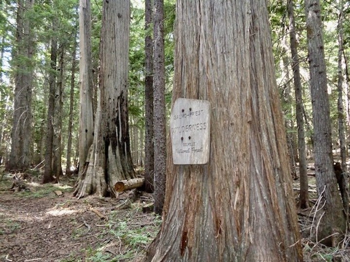
At the three mile mark, the trail enters the Salmo-Priest Wilderness, and at the 5.1 mile mark it intersects the Shedroof Divide Trail. Day hikers may want to turn back at the junction (although even if planning an out and back, consider the additional short hike to the top of the first hill on the Shedroof Divide going north for its outstanding view overlooking Priest Lake and the Idaho Selkirks). With several intersecting trails along the Shedroof Divide, numerous route options are available for backpackers who wish to extend their time in the Salmo-Priest.  

WTA worked here in 2020, 2019, 2018, 2017, 2016, 2015 and 2014!

Thunder Creek

Map & Directions

Trailhead
Co-ordinates: 48.9168, -117.0621 Open in Google Maps

Before You Go

See weather forecast

Parking Pass/Entry Fee

None

WTA Pro Tip: Save a copy of our directions before you leave! App-based driving directions aren't always accurate and data connections may be unreliable as you drive to the trailhead.

Getting There

From Sullivan Lake travel Forest Road 22 (Sullivan Creek Road) 5.9 miles. Bear slight left at the Y intersection to continue on Forest Road 2022000 (Upper Sullivan Creek Road) an additional 6.7 miles. The trailhead is located on the right just beyond the entrance to Gypsy Meadows.

More Hike Details

Trailhead

Eastern Washington > Selkirk Range

Thunder Creek (#526)

Colville National Forest, Sullivan Lake Ranger District

Guidebooks & Maps

Day Hiking Eastern Washington

Craig Romano and Rich Landers

Mountaineers books

Colville National Forest map

Salmo-Priest Wilderness map

You can improve or add to this guidebook entry!

Thunder Creek

9 Trip Reports

Hiked here recently?

Submit a trip report!
 
Trip Reports