

Washington Park sits at the northwestern tip of Anacortes. When viewed from the sea the area is referred to as Fidalgo Head. The terrain varies from rain forest on the north to open, stony hillsides with few trees on the south.
Many trailheads and intersections are well-signed, but a few key trail junctions currently lack signs. This situation is complicated by the many social trails that compete for hikers' attention. Luckily, with a good map (available here) and this writeup, you should be good to go.
To begin, find the sign for Trail 501 on the south side of the access road, near where you parked, and head south on the trail. This corner of the park is rainforest with large firs and cedars, and even larger stumps, and there are a lot of ferns and shrubs in the understory.
At apparent trail intersections, the best signs show arrows and trail numbers. But a few signs just display cryptic graphics, and these may be less helpful. For reference, stay right at the first trail fork. Then head left at each of the next two trail forks. After that, the next two upcoming trail forks are marked with the trail number and arrows so you can stay on Trail 501.
Between those last two trail forks you will pass a heron rookery. You have to look carefully to see the birds and nests, although in June and early July you certainly will hear the demanding calls of hungry chicks.
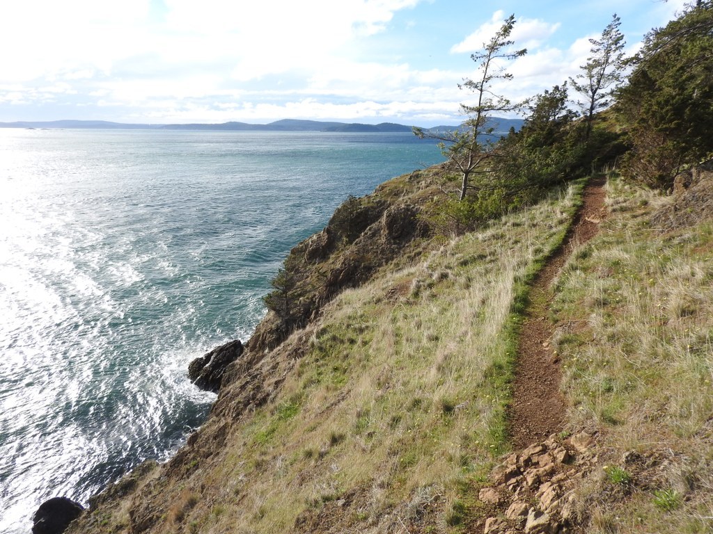
At the next trail junction turn left onto the signed Trail 502 and head downhill. Try to stay on the official trail as it switchbacks a few times, and avoid the social trail that heads left toward a link fence. At the bottom, meander over to the grassy bluff for the views back toward Anacortes, with Sugarloaf and Mount Erie in the distance.
The prominent trail to your left leads to a private building. Your ongoing route (Trail 502) heads right, sometimes in the trees, sometimes in more open areas, and often traversing steep slopes where you will need to watch your footing.
In about 1200 feet, be alert for a metal sign in a tree on your right (it's facing the opposite direction). It flags your upcoming junction with Trail 503 that bends very sharply right and heads steeply uphill. The other paths you see heading uphill here are social trails, best avoided.
But first note that your Trail 502 continues on a bit farther, heading downhill toward the water. That's an optional side trip of about 400 feet each way, with elevation change about 80 feet, and you might enjoy doing it for the close-up views of the water.
Either after that side trip, or immediately, head up Trail 503. In about 400 feet of steep uphill, gaining about 90 feet of elevation, you will intersect Trail 501 (another section of the trail you started out on).
Two options here: Either head right on Trail 501 for about 100 feet, then head left up the short path with the stone steps to reach the Burrows Channel Viewpoint. There are two information boards here, one describes a few of the local wildflowers, the other summarizes some local history. And there is a portable toilet across the road, the only one you will find until you return to your trailhead.
Or, if you are skipping the viewpoint, just head left here (toward open water) and continue west on Trail 501. In about 300 feet the unsigned Trail 504 arrives from the right. It's an alternative route down from the viewpoint. And a bit later a social trail joins your route from the left. Just continue straight on Trail 501.
Soon, come to a signed junction where Trail 506 arrives from the right and your Trail 501 continues on straight. But be careful! A prominent social trail bears left here. That's not your route! Your Trail 501 is the less prominent trail that goes straight ahead here.
In 200 feet the signed Trail 505 crosses your route. As an optional side trip, take Trail 505 left for about 600 feet, dropping about 100 feet, to a viewpoint near the water's edge. Along the way there are some interesting rock faces exposed just east of the trail. A signboard at the bottom proclaims "Burrows Channel," and the island across the way is Burrows Island.
Return to Trail 501 and continue on it another 1500 feet or so to reach a signed T-junction with Trail 510. Head left there. In about 150 feet note an unsigned junction on the left for Trail 512. This short side trail (about 300 feet each way) leads to a viewpoint that is worth seeing, next to some picturesque trees. (Minor social trails might continue on, but you should turn around at the trees and return to Trail 510.)
In another 300 feet you will come to a series of trail intersections where you might find the map, the signs, and the trails somewhat confusing. Here's a good way to negotiate them:
About 150 feet before you reach a large granite boulder (a glacial erratic) be alert for a three-way trail junction. The ongoing trail is signed Trail 510, and you will see the sign for Trail 515 that arrives from your right. It's easy to overlook the fainter Trail 513 that heads off to the left here (the trail sign is in a small tree, about 50 feet down the trail.)
Take Trail 513 as it heads downhill. Soon, you may see a trail junction sign for other trails just 100 feet off to your right. It's best to ignore that sign. Don't go there! Just continue down and slightly left on Trail 513 and soon you will be rewarded with a bench seat offering an unobstructed view of the surrounding waters and islands.
With luck you will have the bench all to yourself. Enjoy it for a while, then take Trail 513 back to Trail 510 and continue on west.
In about 200, feet come to another unsigned trail junction. This one really needs a sign because Trail 516 heads right here, toward the road, and that's an optional, easier route back to your trailhead. But at least take the left fork for a short distance. At a trail fork stay right, and soon you will come to another bench seat, this one with a view framed by trees. Enjoy this one for a while too.
To continue, either return to trail 516 and head north on it or, for a more adventurous route, take the trail that heads very steeply downhill from the bench (not the narrow crack to the right, and not the social trail to the left.) This ongoing route is - or becomes - Trail 517. Try to stay on the main trail here and avoid minor social trails. After a few switchbacks the trail bends sharply to the right and levels out.
In a short distance a prominent trail bends sharply left and heads downhill toward the water. You can check it out if you like. It ends in about 200 feet at a signboard that proclaims "Rosario Straight," which is the body of water to the west of Fidalgo Head.
Come back to Trail 517 and continue on north to meet the one-way Loop Road. Turn right and follow the road for about 500 feet. Traffic generally is light, and it's one-way in the direction you will be walking.
When you come to the sign post for Trail 516, where it crosses the road, head left on that trail. (If you took the easier return route back from the second bench you will end up here.)
Follow Trail 516 for about one-third of a mile. It's relatively level and is forested the entire way. Along the way you will cross over Trail 518, and will a note a couple of minor side trails that head left out to the road.
Eventually, you will cross the road again, and continue on as Trail 516 bends around to the right and follows a narrow, rooty route above the shoreline. There are frequent good views out, and steeply down, to the water and rocky shore.
When you come to a signed trail fork with the beach indicated left, take the right fork instead. It will return you to the loop road. The restrooms are in the white building ahead and slightly uphill.
To return to your parking area head east (the beach will be to your left and the boat trailer parking area to your right.) Soon you will see your car up ahead.
In addition to the herons, it's likely you also will have seen gulls, ravens, crows, and robins. Perhaps even an eagle. And other birds appear here seasonally. You might see a deer in the heavily forested area (although they browse the yards in town too.) In season you will find a few wildflowers. If you are a flower fancier, take a few photos and when you get home check a flower guide and try to identify any that you don't know.

 Trailhead


