
If you want to take a quick hike near the Renewable Energy Center of the Wild Horse Wind and Solar Facility (REC), then this is your trail. The trail descends through rigid sage, balsamroot, buckwheat, and bitterroot which thrive in the thin rocky soil on the hillside.
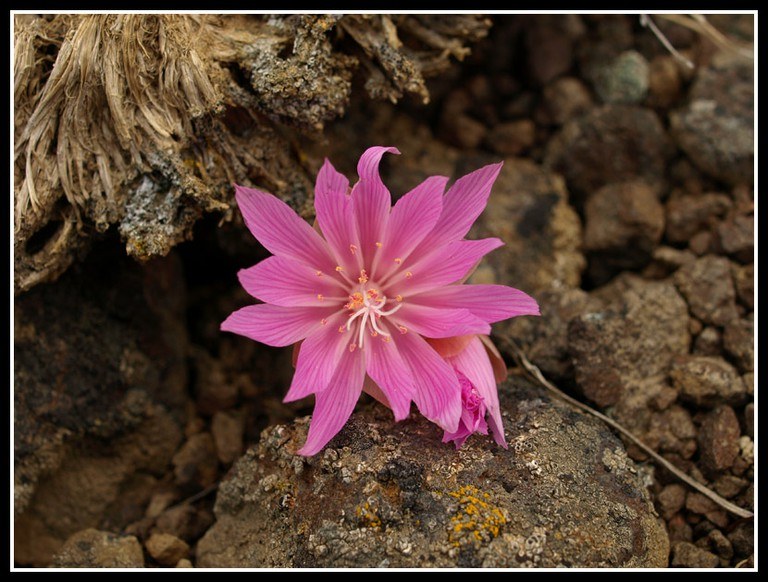
Bitterroot (Lewisia rediviva), the star of this trail, appears with a rosette of rounded spike like leaves in early spring. The plant is a succulent, storing water in its leaves to combat drought conditions. The plant uses up much of its stored energy to produce a spray of pink flowers, which appear for only a short time, usually after its leaves have shriveled. The roots were a common Native American food source. They were dug up, peeled, and either cooked or dried for future use or trade.
This route begins on the gravel trail behind the REC. Walk between the solar panels and the blade, following the trail north. It soon takes a sharp left and heads down hill, ending at a pull off along Beacon Ridge Road. Retrace your steps from here, or continue down the Bluebird Trail, which begins across the road. For your safety, please do not walk on or along the roadway.
Whiskey Dick Wildlife Area - Bitterroot Trail

-
 Length
- 1.0 miles, roundtrip
-
 Elevation Gain
- 185 feet
If you want to take a quick hike near the Renewable Energy Center of the Wild Horse Wind and Solar Facility, then this is your trail. The trail descends through rigid sage, balsamroot, buckwheat, and bitterroot which thrive in the thin rocky soil on the hillside.
Continue reading
Hiking Whiskey Dick Wildlife Area - Bitterroot Trail
Map & Directions
 Trailhead
Before You Go
WTA Pro Tip: Save a copy of our directions before you leave! App-based driving directions aren't always accurate and data connections may be unreliable as you drive to the trailhead.
Getting There
Drive east on Interstate 90 to exit 115 for Kittitas and head north over the freeway. Turn left onto Cleman Rd/Main Street and follow Main Street for just under a mile. Turn right onto Railroad Avenue and continue onto Clark St. Turn right onto Parke Creek Road and drive for just over 5.5 miles, then turn right onto Vantage Highway. Turn left onto Beacon Ridge Road, and the trailhead is on the left.
Note: Lands within the Wild Horse Wind and Solar Facility are open to hunting, hiking, biking, bird watching, horseback riding and other recreational activities by written permission only. The entry gate off of the Vantage Highway is open April 1 to Nov. 30, from two hours before sunrise to two hours after sunset.
To get permission to walk the grounds, complete the free online application form then pick up your permit at the Renewable Energy Center from 9:00-5:30, seven days a week. You can also fill out the entire permit in person at the Renewable Energy Center. The free permit is valid from April through November of that year.


