
Hike trails named in honor of mountaineers Jim Whittaker and Nawang Gombu, of 1963 Mount Everest ascent fame. Wilderness Peak may not be Everest, but it is the highest point in King County's Cougar Mountain Regional Wildland Park and it does have some wonderful old-growth conifers. This loop hike offers a diversity of steep forested hillsides, huge mossy boulders, and a low swampy area traversed via a narrow boardwalk.
Begin your hike on the Whittaker Wilderness Peak Trail. It immediately crosses a rustic bridge and begins to switchback uphill. It's a very green forest walk, with a lot of ferns and moss, a few small streams and some large glacial erratic boulders. In spring, be alert for wildflowers including trillium, yellow violet, and avens.
In 0.5 mi, turn right at the sign onto the Gombu Wilderness Cliffs Trail. This 1.3 mi trail will rejoin the Whittaker Trail at its upper end, but it provides a shorter, somewhat steeper route to the summit of Wilderness Peak. The first few yards of Gombu's trail trend slightly downhill, but very soon your climb will resume. It's a fine forest trail, traversing some fairly steep hillsides, but despite the name there are no genuine cliffs.
Eventually, the route drops a few feet, and early in the season there may be a small pond to the right of the trail. The uphill resumes for a short while, then the trail crosses a ridge and drops to rejoin the Whittaker Trail at its upper end. Here, an 0.1 mi side trail leads to the gently rounded, forested "summit" of 1,598-foot Wilderness Peak, the highest point in the Cougars.
There is no view from the summit, although there is a bench for any hikers who might want to sit after the 1,200-foot climb from the trailhead. You can sign the "summit register" if you like, and add comments about anything unusual you may have seen on your way up.
When you are rested you could return the way you came, but it's much more interesting to continue your hike as a loop and return via the Whittaker trail.
The ongoing Whittaker trail heads gently downhill to the west and in 0.5 mi reaches Shy Bear Pass, where several trails meet. (Yes, a few black bears do make the Cougars their home, but a sighting of the eponymous bashful bruin here is very unlikely.)
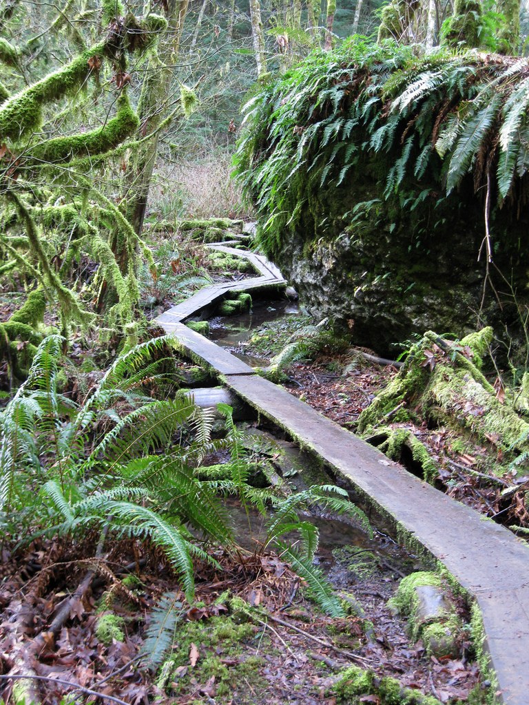
Continue on Whittaker's trail as it bends around toward the east and descends some more. Soon, the trail crosses the marshy area of Big Bottom Bog. Early in the season there will be a lot of standing water, and mud later on. The tread here is on a very narrow boardwalk that zigzags around large boulders. Be alert for any hikers who might be coming from the opposite direction, and if you encounter any try to cope the best you can.
Continuing on, you will pass still more large boulders, including one huge overhanging rock with a "cave" beneath it, offering a possible storm shelter for any hiker or critter in need.
All too soon, your trail returns to the junction with Gombu's trail, and you will have completed the loop part of your hike. From there, just stay on the Whittaker trail to return to your trailhead.
Extending your hike: Want to double the length and fun of your hike, but with only a little more elevation change? You can add an additional loop to your route when you reach the half-way point. As you approach Shy Bear Pass, be alert for the signed Shy Bear Trail on your right and take it westward. After about 0.4 mi, pass a junction with the Quarry Trail and continue on the Shy Bear Trail. Soon, your trail drops down to Shy Bear Marsh and crosses the marshy area on a rustic boardwalk.
About 0.5 mi beyond the boardwalk, be alert for a weathered sign on the left that announces the junction with the Deceiver Trail (no history is provided, so you are free to speculate about the name.) Turn onto this trail and continue generally south and east. In about 0.5 mi, note a signed trail on the right leading to Doughty Falls. Early in the season the water will be running, although in late summer the falls may be dry. The falls are small, but they are picturesque and it's well worth the short side trip for a look (perhaps 200 ft, with 45 ft elevation loss.) If you are here in the early afternoon on a sunny day, the falls will be brightly lit by the sun.
Return to the Deceiver Trail, continue on and come to a fork that may be unsigned. Your map may indicate the right fork leads to a viewpoint. You can check it out if you like, but it's minimal. Trees continue to grow, and today the view window is very small. To reach it, you have to hike up over the knoll you see in front of you, then drop a few feet down the other side. If you go that far, you will find a bench at the viewpoint.
Back at the unsigned fork on the Deceiver Trail take the left fork, shown on your map as the Long View Peak Trail. It will lead you back to Shy Bear Pass in about 1 mile, passing a junction with the Ring Road Trail along the way. From the pass, resume your hike on the Whittaker trail, and return to your trailhead.
Wilderness Peak Loop

-
 Length
- 4.0 miles, roundtrip
-
 Elevation Gain
- 1,200 feet
-
 Highest Point
- 1,598 feet
Hike trails named in honor of mountaineers Jim Whittaker and Nawang Gombu, of 1963 Mount Everest ascent fame. Wilderness Peak may not be Everest, but it is the highest point in King County's Cougar Mountain Regional Wildland Park and it does have some wonderful old-growth conifers. This loop offers a diversity of steep forested hillsides, huge mossy boulders, and a low swampy area traversed via a narrow boardwalk.
Continue reading
Parking Pass/Entry Fee
NoneHiking Wilderness Peak Loop

WTA worked here in 2020 and 2019!
Map & Directions
 Trailhead
Before You Go
Parking Pass/Entry Fee
NoneWTA Pro Tip: Save a copy of our directions before you leave! App-based driving directions aren't always accurate and data connections may be unreliable as you drive to the trailhead.
Getting There
From I-90, near the western edge of Issaquah, take Exit 15 and head south on Highway 900 (aka 17th Ave NW or, later, Renton-Issaquah Rd SE.) In a bit over three miles from I-90, be alert for a blue sign with white letters on the right side of the road, which reads "Cougar Mountain Regional Wildland Park / Jim Whittaker Wilderness Peak Trailhead." Slow down, and just before the sign turn uphill on the asphalt road that leads into a small parking area at an elevation of 395 feet. There is room for about a dozen cars, and no permit is required. A portable toilet is available but no regular water source.
You can look over the information board, and often you will find paper copies of a trail map available for the taking. If you prefer, the trail map can be downloaded in advance. It takes several clicks to get there. From www.kingcounty.gov begin with "Services / Parks and Recreation," then "How do I Find / Hiking Trails," then "Backcountry Trails," then "Cougar Mountain," and finally "Cougar Mountain Map." The map is on Page 2 of the downloaded pdf file.
Park trails are open from 8 AM until dusk. The Whittaker and Gombu trails are designated for hikers only, i.e. no bikes or horses. Dogs are welcome, but must be on a leash.


