Trails for everyone, forever

Home Go Hiking Hiking Guide Wilson Creek Canyon

Wilson Creek Canyon

Central Washington > Grand Coulee
47.6771, -118.8500 Map & Directions
Length
0.8 miles, roundtrip
Elevation Gain
37 feet
Highest Point
2,065 feet
Calculated Difficulty About Calculated Difficulty
Easy
Views from the Wilson Creek Canyon trail. Photo by Mary Hartman. Full-size image
  • Dogs allowed on leash
  • Good for kids
  • Wildflowers/Meadows
  • Wildlife

Parking Pass/Entry Fee

None
Saved to My Backpack

This short, easy hike in the Wilson Creek Canyon of Eastern Washington’s channeled scablands offers beautiful vistas, mature sagebrush, wildflowers, and an abundance of birds. Continue reading

Rating
3.80 out of 5

(5 votes) Log in to rate

Hiking Wilson Creek Canyon

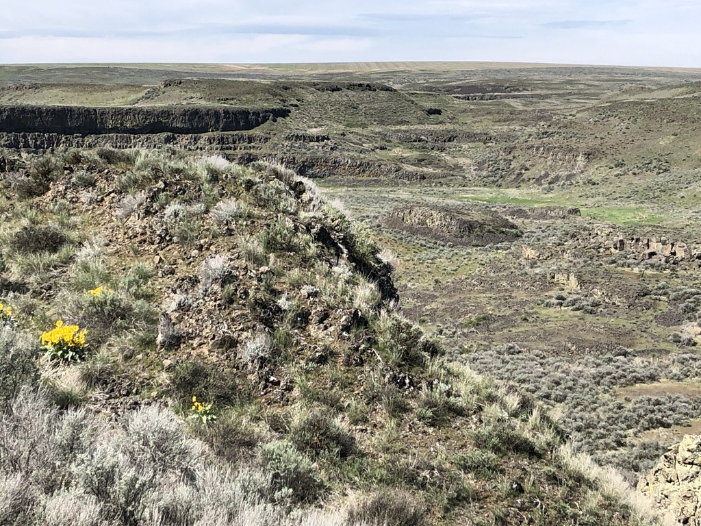
Wilson Creek is a tiny waterway at the bottom of a surprisingly large canyon, a product of the ice age floods that formed the channeled scablands of Eastern Washington. Steep slopes and basalt cliffs create stunning views. Wildflowers abound in the spring, and the canyon provides habitat for many species of birds, mammals, and reptiles.

From the parking area, step through the gate and follow the crushed-gravel trail as it winds through shrub steppe with mature sagebrush. The trail ends at about 0.4 mile where there is a signboard describing the local habitat. If you wish, you can continue to hike beyond the trail another quarter mile to the west before the terrain gets too steep for safe hiking.

Note that there is no potable water on this trail, and especially in spring, look out for rattlesnakes.

WTA Pro Tip: While you’re in the area, drive back to Lewis Creek Road, turn left, and cross the bridge. You can pull off on the left and then ramble alongside Wilson Creek.

Toilet Information

  • No toilet at trailhead

More information about toilets

Hike Description Written by
Mary Hartman, WTA Correspondent

Wilson Creek Canyon

Map & Directions

Trailhead
Co-ordinates: 47.6771, -118.8500 Open in Google Maps

Before You Go

See weather forecast

Parking Pass/Entry Fee

None

WTA Pro Tip: Save a copy of our directions before you leave! App-based driving directions aren't always accurate and data connections may be unreliable as you drive to the trailhead.

Getting There

From the west: Follow Highway 2 about 25 miles east from Coulee City and turn right on Govan Road. From the east: Follow US 2 about 4.5 miles west from Wilbur and turn left on Govan Road. Proceed on Govan Road about 5.4 miles; it twists and turns a bit, so watch the signs.

Turn right on Lewis Bridge Road, which is a wide, well-maintained gravel road. After 1 mile, turn left onto Union Valley Road (also gravel). Travel a half mile and pull into the parking area on the right, which is marked with a “Wildflower Viewing Area” sign. The trailhead is easy to access, despite its remoteness. The gravel roads are wide and well-maintained.

The parking area is a small gravel lot with space for four or five cars. There is no space for trailers or large RVs. No restroom, potable water, or trash cans.

More Hike Details

Trailhead

Central Washington > Grand Coulee

Bureau of Land Management

Guidebooks & Maps

Best Desert Hikes: Washington (Bauer & Nelson - Mountaineers Books)

Bureau of Land Management Govan Recreation Area website - https://www.blm.gov/visit/govan-recreation-site

Washington State Department of Natural Resources (DNR) Coulee Dam

You can improve or add to this guidebook entry!

Wilson Creek Canyon

2 Trip Reports

Hiked here recently?

Submit a trip report!
 
Loading trip reports...
Trip Reports