
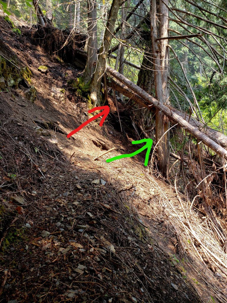
Started at East Bank Trailhead to go counterclockwise. Ruby Creek Trail section was a bit brushy and overgrown. The rockslide/washout that others have mentioned is actually located just beyond where the old Canyon Creek footbridge used to be. We did find the hornet's nest in the middle of this slide, but were able to get through by a path around it. If you look at the photo, the red arrow points the easiest path through, but that's where the nest is. You can't see it until you are beyond it. If you follow the green arrow path around the right side of that tree, once you are beyond it, there is a notch up to your left you can climb through, then you go around the root ball of a downed tree, and down to the right, to get back to the trail.
The only other obstacle we encountered that took a while to get past, was a scree slope where the trail goes very steeply down with very loose footing. This is between Devil's Park, and a ridge that was labeled on the map as "Anacortes Crossing". Took some time slowly picking our way down this, to get to the bottom safely. Plan to move slowly/carefully here.
We did not have any trouble staying supplied with water, which is sometimes a problem on this loop hike, but it is worthwhile to stay topped up whenever you do pass a good source. We did not utilize the spring below Devil's Pass, but we were told by other hikers that it was mostly dry and would need to be dug out to be used as a water source, so plan for that as well.
Bugs were definitely persistent from the trailhead up until about Devil's Pass. Spray made it tolerable, and thermacell definitely helped when we stopped for the night.
In some areas there were enough trees down across the trail that it got a bit tiresome, but we didn't encounter anything impassable once we had traversed the rockslide at the beginning.
When we finished the loop and got back to Ruby Creek bridge, there was a notice that the trail is closed due to new fire activity, somewhere in the Canyon Creek drainage, so make sure you check on this.
This loop is a pretty classic Cascade mountain hike, with forests, meadows, spectacular mountain views (especially the 360 degree vista from the top of Devil's Dome), and a chance to take a refreshing swim in Ross Lake. Well worth your time, if you are prepared for a LOT of elevation gain/loss over the course of any given day.

Comments
pnw backpacker on Devils Dome Loop
Thank you for posting. Do you recall if you found water at Devils Park around mile 9 and/or the South Fork of Devils Creek around mile 12?
Posted by:
pnw backpacker on Aug 09, 2021 05:11 PM
GraySkies on Devils Dome Loop
There is water in Devils Park behind the shelter.
I'm not sure what you're designating as South Fork Devils Creek (not shown on my map by that name) but there's good water in the valley before the 6100' point near Anacortes Crossing (ridge)as shown on the Green Trails 16SX map. Besides that water approx one mile before that point (unknown tributary name), there's also water one mile after that point at the North Fork of Devils Creek.
Posted by:
GraySkies on Aug 09, 2021 05:47 PM