

This loop provides solitude, expansive views, varied terrain and side trips to several special places. Though it could be done in three long days, four or more is recommended. Dry, subalpine ridges, old growth forest, massive flower packed meadows, and glaciated peaks makes this trip a nonstop North Cascades life-list backpack!
There are several options for how exactly to handle this trip, so it is important to study a map and do your research. Conditions on such a long trip can also change from year to year making it doubly important to read what current hikers are saying in their trip reports. Early summer can still be snowy at these heights and midsummer can be buggy. Autumn has brilliant colors and few bugs but the days are getting shorter and cooler. Many sections of this trail are dry so research reliable water sources for your trip and prepare to carry more water than you might be used to.
Proceeding clockwise from the trailhead, descend to Ruby Creek and turn left. This old roadbed contours along the hillside slowly gaining elevation to Hidden Hand Pass. This pass is noteworthy for being instrumental to miners accessing the upper Skagit River prior to the damming of the gorge. As the East Bank Trail continues north along Ross Lake it slowly drops 900 feet and eventually comes level with the lake. There are several campsites along the lake which all require a permit from the National Park.
At Devil’s Creek Campground turn onto Devil’s Ridge Trail, which is generally well maintained and relentless in its 5,200-foot ascension to the summit of Devil’s Dome. Initially the trail goes through old-growth forest then gradually breaks out onto scree slopes and eventually above tree-line. Along the way amazing views of the north face of Jack Mountain and the Nohokomeen glacier will keep you entertained. The first potential opportunity for water since leaving the lake is at the questionably named Dry Creek Pass. A short distance late,r a side trail leads to Bear Skull Shelter.
Beyond Bear Skull the trail rises above the tree line for several miles. Views are stunning and stretch to the horizon in every direction. The North Cascades are all around you, the Pasayten Wilderness stretches eastward, and British Columbia looms off to the north. More prominent peaks than one can count bleed off into the distance. Devil’s Dome makes for a fantastic campsite, albeit dry and exposed.
In the 1950s several beatnik poets worked the fire lookouts in this area (Gary Snyder and Jack Kerouac among them). Visiting their former lookouts or simply reading their prose while rambling in these hills can be inspirational.
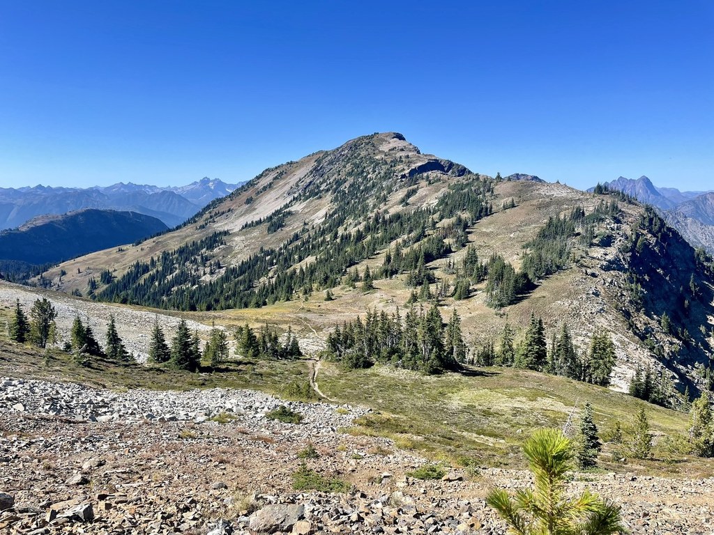
A long stretch of over 15 miles connects Devil’s Dome and Devil’s Park. For the most part the trail traverses above tree line with huge views and flower packed meadows. Water can be scarce along here so plan accordingly. Devil’s Pass may have water a few hundred yards down the north side. After passing the turnoff for Anacortes Crossing, the trail drops 1,000 feet to a decent campsite with the first truly reliable water since leaving the lake.
The trail regains the 1,000 feet in a mostly wooded drainage. Over the next several miles you’ll contour alongside Jackita Ridge through endless flower meadows with stupendous views of the rugged eastern flank of Jack Mountain. Devil’s Park Shelter makes for a good place to camp and generally has water.
Descend from Devil’s Park for about 4,800 feet through meadows and old growth. If time allows, a fantastic one-day side trip is possible during this descent. Just as you leave McMillan Park a trail turns off to the right to Crater Mountain. One mile and 500 feet elevation gain brings you to a lake and pleasant basecamp to drop some weight before heading on to the summit of Crater. This is a considerable side trip with an exposed scramble at the top.
Back on the main loop, the trail drops down to Canyon Creek then along Ruby Creek for two miles back to the trailhead.
Several options to lengthen this adventure exist and one option can make it shorter. The Ross Lake resort offers a boat shuttle to the base of Devil’s Creek trail. This can be used as a pick-up or drop off to shorten the hike by about 12 miles. Conversely, side adventures to Crater Mountain, Anacortes Pass, or elsewhere can lengthen your exploring.
WTA Pro Tip: This is a long, remote hike. Conditions can vary considerably from year to year. Trip reports are your best resource for assessing water availability, brush, and general conditions. There aren’t any real “outs” on this loop and cell service is nonexistent. Be prepared.

 Trailhead


