June 4, 2022
I successfully made it to Carbon Glacier and explored the Old Mine! I was pleased with this hike for my last one. For those who don’t know, I’m moving to North Carolina, and I had to pick one last hike here, and this is what I chose, an excellent choice.
We got to the trailhead at 8:06 AM and decided to do the Old Mine first before the Glacier. We were on bikes, so it didn’t take long to go the first mile to the mine turnoff. When we got to the mine, we explored it; however, WTA will delete my trip report if I talk about that.
If you want to know what’s inside the mine, please go to my Nwhikers trip report. http://www.nwhikers.net/forums/viewtopic.php?p=1232388#1232388. I would put that here but WTA will delete my TR. Anyway, we continued on our bikes for a while. Between the Chenius Falls junction, there are four dismount sections that are brief. Once we got to Ipsut Campground, we got off our bikes.
After Ipsut Campground, we decided to check out the Trail to Ipsut Falls. It was worth hiking the extra 300 feet to the raging falls. They were beautiful. I know it doesn’t look like much when you look at photos of it, but cameras have a hard time with waterfalls.
We continued until the Lower Carbon crossing. A washout has destroyed the switchbacks that used to take you down to the riverbed. We scrambled down to the river’s edge, searching for a log or a place to hop over boulders. I knew from the start It wasn’t easy.
I found a spot that looked like I might be able to boulder hop If I had my trekking poles in the water for balance as I hopped across. All was well until I reached the middle of the river, where I stuck my trekking pole in the water for balance. It got yanked so hard I had to let go. If I kept holding on to the trekking pole, I would have lost my balance and fallen into the water.
I never found that trekking pole; if you return It, I’d appreciate it. It’s a black aluminum trekking pole at the bottom of the river at the Lower Crossing. I still had my other trekking pole with me, which was very helpful later. We couldn’t cross the river no matter how hard we tried to look for a spot, so we looked at another option.
We thought we could walk the riverbed for 1 mile until the suspension bridge where we could get across, which would be difficult, but there was nothing else we could do. So, we continued up the riverbed until the river got too close to a cliff and cut us off. Not sure what to do from there, we sat there and looked around.
The former Wonderland Trail was abandoned years ago on the west bank of the river because of a vast washout. However, we were past the washout area and could see the old trail on a ledge above the bank. Taking a dilapidated path to the bridge was our only option for success. Good thing a snowfield aided getting up the ledge.
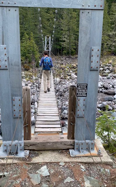
The abandoned Wonderland Trail was severely overgrown in the first half, but the second half was better. Finally, we reached the long suspension bridge, and our hard work paid off. We crossed the mighty structure, admiring the raging river below. Now the glacier was in full view. Once we got to the glacier viewpoint, we weren’t stopping here.
I do not recommend you go to the snout. It’s hazardous and takes a very long time. There is icefall, rockfall, and the river will drown you. Why did we do it? So, you don’t have to if you want a picture of the glacier up close. With that said, we went down to it. Getting there was complicated. The boulders slow you down, and Moraine Creek is nearly impossible to cross.
It took forever to find a place to cross Moraine Creek, but finally, it split into two (braided), and we got across. When we finally got to that glacier, I slapped my hand against that dirty ice wall and yelled to my dad I’m touching a glacier! We wanted to go into the snout, but enormous boulders would not stop falling. You would think that it would be like one boulder every 10 minutes. No, it was ten boulders per minute! We almost go stoned alive nearing that snout, DO NOT go down there unless you're dumb like us.
We watched those boulders tumble down from a distance, barely far enough for them not to reach us. It was pretty entertaining. After the glacier and the scramble all over again, we arrived back on the main trail at 2:30. That’s when it started to rain. Thank goodness we were done with the boulder scrambling because it would be too slick in the rain.
Once we got back to the suspension bridge, we were met with a hard decision. We could either take the main trail in good condition and cross the river on a log jam if we found one, or go back the way we came and cross the river safely on the bridge and have terrible abandoned trail conditions. We could never find a log jam at the lower crossing on our way up, so we decided on the suspension bridge to be a safer approach.
After so much scrambling and obstacles, we finally made it back to the main trail. We hiked through the pleasant semi rainforest until we got back to Ipsut Campground. We got on our bikes and went 5 miles in 45 minutes. We were mainly coasting. Overall, one of my favorite hikes of all time, I loved it, and I made a great decision on my last one.
10 miles of hard hiking, and 10 miles of biking.
If you have any questions, write them in the comments.


Comments
Seattle_Wayne on Carbon Glacier, Old Mine Trail, Carbon River to Ipsut Falls
Why would WTA delete your trip report if you talked about exploring the old mine?
Posted by:
Seattle_Wayne on Jun 06, 2022 05:06 AM
Hiking addict on Carbon Glacier, Old Mine Trail, Carbon River to Ipsut Falls
It’s because the park service closed it off with a metal grate, however the grate was vandalized so people can get squeeze through it. However, if I show that WTA staff will say that I’m trespassing and therefore delete my trip report. It’s happened before.
Posted by:
Hiking addict on Jun 06, 2022 09:51 AM
Seattle_Wayne on Carbon Glacier, Old Mine Trail, Carbon River to Ipsut Falls
Oh, that's right. I remember when the covid pandemic started and all the hiking trails were closed but people were hiking anyway. I hiked Dirty Harry's Balcony, which was "closed" and they kept deleting my trip report.
I'm glad you had a great last hike here in Washington. Rainier would've been my top pick if I were to choose one last hike. Sounds like you had a very awesome trip. Good luck on the East Coast!
Posted by:
Seattle_Wayne on Jun 06, 2022 10:10 AM
Hiking addict on Carbon Glacier, Old Mine Trail, Carbon River to Ipsut Falls
Thanks, I’ve actually never been to the east coast in my life, nothing east of Indiana except Georgia Florida and North Carolina but that was a long time ago.
Posted by:
Hiking addict on Jun 06, 2022 10:16 AM
Paul At Rainier on Carbon Glacier, Old Mine Trail, Carbon River to Ipsut Falls
I’m glad you had such a great hike and appreciate that you tried to point out the dangers at the snout of the glacier, which is much more hazardous than any mine shaft. I’ve sat at the edge of the trail up above the terminus dozens of times (I’m not exaggerating—I’ve hiked there a lot) and sometimes see boulders the size of cars tumble off the top, and slabs of rotten ice come down as well.
Posted by:
Paul At Rainier on Jun 06, 2022 11:37 AM
Hiking addict on Carbon Glacier, Old Mine Trail, Carbon River to Ipsut Falls
I went down there because there is no photos or videos near the terminus, so I wanted to capture those amazing shots so no other hikes have to, and now I can say I've touched a glacier. We saw tons of rockfall so we couldn't go into the ice tunnel.
Posted by:
Hiking addict on Jun 06, 2022 12:20 PM
Hiking addict on Carbon Glacier, Old Mine Trail, Carbon River to Ipsut Falls
I also caught amazing videos of enormous boulders flying down the glacier, however I do not encourage any of you to go down there.
Posted by:
Hiking addict on Jun 06, 2022 01:07 PM
Lisa Elliott on Carbon Glacier, Old Mine Trail, Carbon River to Ipsut Falls
Thank you for the report. Glad you made it safely. Did you happen to stop in at the Carbon Station to see when they might have that trail/footbridge over the Lower Carbon completed?
Posted by:
Lisa Elliott on Jun 06, 2022 01:20 PM
Hiking addict on Carbon Glacier, Old Mine Trail, Carbon River to Ipsut Falls
No, we didn't stop at the ranger station, you can give them a call If you'd like and ask them a few questions, the bridge should be in by the end of this month, I went back and read a few trip report from around this time, and the bridge normally gets put in around mid to late June.
Posted by:
Hiking addict on Jun 06, 2022 01:59 PM
JamesHaitch on Carbon Glacier, Old Mine Trail, Carbon River to Ipsut Falls
Signs and rules are there to protect people, you ignored them.
Posted by:
JamesHaitch on Jun 08, 2022 04:36 PM
Hiking addict on Carbon Glacier, Old Mine Trail, Carbon River to Ipsut Falls
Yeah we did, but everyone takes risks every day. Now this risk I don’t recommend to anyone, but we decided to because it was worth it for us, besides, I touched a glacier.
Posted by:
Hiking addict on Jun 08, 2022 05:16 PM
Bob and Barb on Carbon Glacier, Old Mine Trail, Carbon River to Ipsut Falls
We wish you the best as you move to North Carolina and we are sure you will find hikes there that will introduce you to the beauties of the area! We have enjoyed your trip reports. I read your report on NW Hikers where I am a lurker, but not a member!
Posted by:
Bob and Barb on Jun 12, 2022 11:08 PM
Hiking addict on Carbon Glacier, Old Mine Trail, Carbon River to Ipsut Falls
Thanks Bob and Barb, I appreciate it. Happy trails!
Posted by:
Hiking addict on Jun 14, 2022 07:55 PM
Hiking addict on Carbon Glacier, Old Mine Trail, Carbon River to Ipsut Falls
Woops, duplicated a comment!
Posted by:
Hiking addict on Jun 14, 2022 07:56 PM