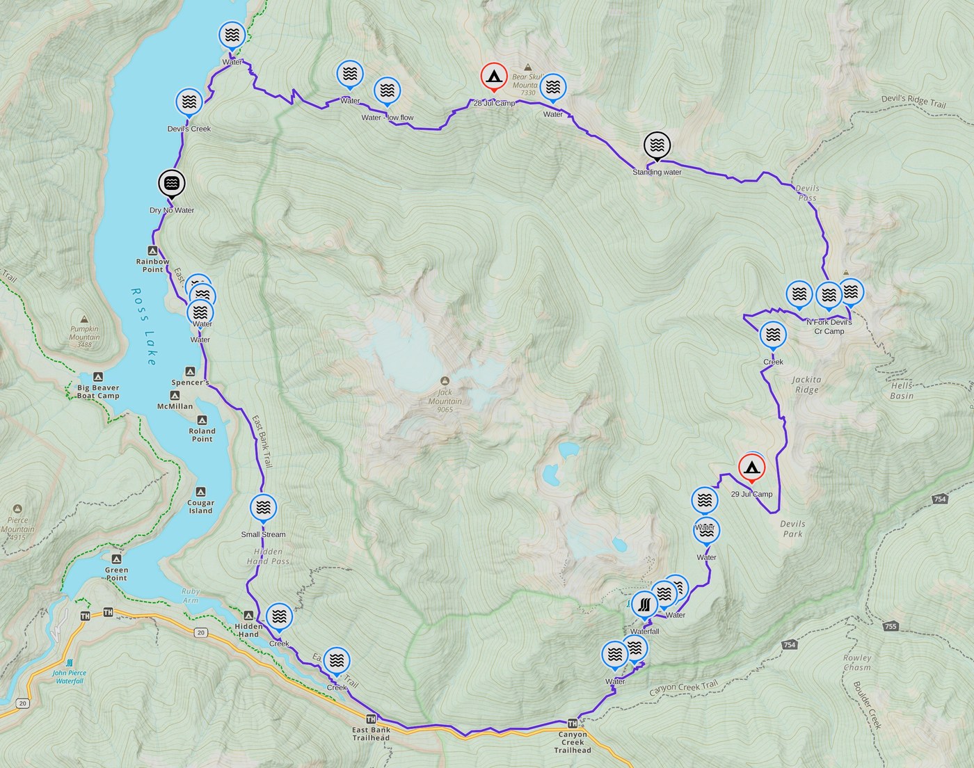
This trip has been on my list for a couple years and I'm stoked to have just completed it CLOCKWISE in two nights this week starting from the EASTBANK TH. It may as well be called the "Tour de Jack" given the views of the mountain it affords for at least half the length. The trail description and other trip reports don't overstate some of the conditions, as the ascents are relentless, brush and blow downs are abundant for much of the Pasayten section, and the sun and heat are harsh along the ridge. However, once away from the boat traffic of Ross Lake, the solitude, views, and QUIETNESS are well worth the effort and "Type 2 fun". Just note, it doesn't seem like 12 miles when you arrive at Devil's Creek campsite for lunch, but once you start uphill you better have eaten all your Wheaties and drunk all your Gatorade!!
BUGS - By "not too bad" I mean they generally didn't bother and bite the ENTIRE time I walked, however, even with long shirt and pants I had many bites after I returned home. Black flies cropped up particularly at Devil's Creek campsite where I had lunch along the lake, and at Devil's Park. Mosquitoes also cropped up early and late at both Devil's Park and Dry Creek Pass. I wore my head net at both tent sites.
BRUSH - Not an issue in the National Recreation Area, but if you have backpacked a lot in Washington, the conditions in the Pasayten won't be suprising as brush is overtaking large portions of the trail, particularly on the ascent from Ross Lake, and in portions of the Jackita Ridge south to the scree slope. Not an issue to simply push through while watching your footing, however, if there was ANY mositure at all during the trip I would have been perpetually SOAKED, so plan clothing appropriately. Descending from Mcmillan Park wasn't bad in comparison, and even Ruby Creek, while less used and brushy, was not as bad as the ascent from Ross. It would be quite a project, but the entire length of the trail is due for a good five-year brushing as the overgrowth is pushing the tread downslope in many areas. Otherwise the tread is in good condition.
BLOWDOWNS - There were just a handful in the Recreation Area, but starting with the ascent from the lake you will encounter a lot of small diameter and older blowdowns which are easily walked over, and in a few cases, under. The worse section of fresher, more complicated blowdowns starts in the saddle just north of Devil's Pass and continues approxiamtely to Anacortes Crossing. There are many which require walking up or downslope to negotiate.
***BEWARE** If you are doing the entire loop from Eastbank TH and finishing with the Ruby Creek Trail, beware the enormous set of blowdowns that took out the Canyon Creek bridge as it stands in your way back to your car. It didn't appear possible to get over them, and downslope is the creek, so I went around on the upslope and immediately regretted my decision as the slope is extremely steep and unstable. The better part of wisdom is to cross the creek (if summer) at the red flag, then cross back over to the Ruby Creek Trail to get around it and back on your way. If you are starting/ending at Canyon Creek TH, then you just need to cross once on the way out and once when you finish the loop, cutting out the blowdowns entirely. Wish I had read Lenore's trip report which describes this (Sep 24, 2024).
WATER - There is adequate water if you hydrate frequently and fill up when you can, but as noted by others, plan for a dry stretch between Devil's Dome and North Fork Devil's Creek of about 6 miles. I did see some standing water downslope in a basin halfway to Devil's Pass that I didn't investigate and you could use in an emergency. I also did not go downslope at Devil's Pass to look for the sources noted in a previous trip report as I had sufficient water at that point. My first camp was at Dry Creek Pass (at the trail, not Bear Skull) and it was indeed a dry camp as I found no water, though I descended a couple hundred feet into the drainage. My 1.5L got me through until the morning. Make good use of the two sources on the ascent at around 4200' and 4600' (smaller). If you are able to press on to the Dome there is water about 300' below it. The attached and linked Gaia maps are just what I observed along the trail. On the way back down to Canyon Creek, there are several sources, and I probably didn't mark all the sources along the East Bank (and of course the length of Ruby Creek).


Comments
NickB on Devil's Dome Loop
Hoping to jump on this with my kids the next few days and this is just the data I needed to hear (esp water sources), thank you!
Posted by:
NickB on Jul 31, 2025 07:34 PM
fadenz on Devil's Dome Loop
Thanks for the great TR!
Posted by:
fadenz on Jul 31, 2025 10:17 PM
Eseandougherty on Devil's Dome Loop
Man the map is clutch. I'm doing this hike soon and this is super helpful. Sincerely thank you for posting.
Posted by:
Eseandougherty on Jul 31, 2025 10:23 PM