Trip Report
Waptus Lake via Waptus River, Polallie Ridge & Waptus Pass — Wednesday, Aug. 17, 2016
 Snoqualmie Region > Salmon La Sac/Teanaway
Type of Hike
Multi-night backpackTrail Conditions
Obstacles on trail:Trees down across trail,
Overgrown in places.
Road
Road recommended for high clearance onlyBugs
Bugs were an annoyanceSnow
Snow free
This trip was a learning experience for me and a friend who spent two nights on a hike we will now call the "accidental loop."
Maybe because we were tired, maybe because we were chatting and not paying close enough attention, we missed the right turn to get onto the Waptus River Trail after leaving the Salmon La Sac Trailhead and ended up on the Pollalie Ridge Trail. We didn't realize this until a couple miles in when we saw the topography we were hiking did not match the section of the map we expected to be on.
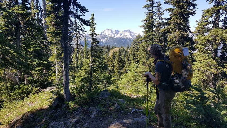
Instead of turning around, we decided to keep going. Originally, we had planned to go up the Waptus River Trail to Waptus Lake and then camp at Spade Lake. This would have meant a 12 mile day, but with fairly little elevation gain compared to the total mileage. However, on this route, we got about the same mileage but much more elevation gain. This trail has false summits galore and lots of rolling hills where you lose all the elevation you've just gained almost immediately. This created a challenging first day, but a fun adventure overall.
The Pollallie Ridge Trail is mostly in good condition, though. The trail is fairly clear, with only a few brushy spots, and in the meadows where the tread disappeared about five miles in, there were helpful cairns leading the way.
The descent from Pollalie Ridge to Waptus Pass was made tricky by a number of trees blown down across the trail. It looks like trail crews have been working hard to clear these all summer, but there are still quite a few obscuring the trail about a quarter mile from where the trail intersects with the Tired Creek Trail. Dozens of large trees are laid across the trail, creating a bit of a jungle gym to climb over. I don't think I'll ever get all the pine sap washed out of the seat of my pants from this section. Debris completely obscured the trail in some sections, which led us to wander for a couple minutes before finding it again. Once we passed this section, though, things cleared up significantly.
We continued down and down and down some more into the Waptus river valley, crossed a few dry creek beds and then, after passing the sign for Quick Creek Camp, took a left across the horse ford to Waptus Lake. The horse ford is very low right now, only up to my shins (I am 5' 3"). We never made it to Spade Lake. After leaving the trailhead at 8:45 am, we made it to the campground at Waptus Lake around 6 pm and decided to stay the night there. It was a long, hot day and not at all what we had planned. However, it was gorgeous and there are SO MANY ripe huckleberries along this trail right now. Our hands were purple from picking them. We saw quite a few green and red ones, too, so it looks like there will be an abundance of berries for the next few weeks at least.
On day 2, it was even warmer. We decided that we wanted a more leisurely day than before, so we went 5 miles down the Waptus River Trail to a swimming hole a couple at Waptus Lake had told us about. It was glorious and not too cold.
After our break to swim, we hiked another mile down the trail to the first camp marked on the Waptus River Trail (about 3 miles from the trailhead). There is a gorgeous waterfall in view of the camp that my hiking partner walked upriver to see. The water is pretty low right now and she said it was a pretty easy walk in Crocs.
On day 3, we set out from camp at 7:15 and were back to the trailhead by 9. We laughed at our initial mistake but were actually pretty satisfied with the loop. I'm looking forward to going back to actually make it to Spade Lake!
Lesson learned: Always bring the Green Trails Maps that are adjacent to the map you know you need in case plans change.


Comments