
This was my first backpack in Washington, having done most of my backpacking / backcountry climbing in the Sierra. The itinerary was NF Quinault --> Elwha Basin --> Queets Basin --> Mt Ferry --> Dodger Point --> Whiskey Bend. Some 45-50 miles, over 5 days.
Day 1 was 12 miles of quick hiking over excellent trail to 16 mile camp. The old growth was exquisite. Day 2 took us over Low Divide, down to Chicago Camp, and then 3 miles up to Elwha Basin. Those final 3 miles were characterized by many down trees, overgrown trail, and hornets galore. No one (party of 4) was spared. The trail ended at one branch of the river, which was forded via some precarious logs. Nice tent platforms and a fire ring were found on what turns out to be a small island between two forks of the river.
We spent an hour that afternoon trying to scope out the start of the route up the Elwha Snow Finger. We tried the scrubby meadow to lookers left of the river (one piece of pink flagging led us that way). Two tries led us nowhere. We tried walking up the river bed a ways and, while possible, the slick rock and repeated required crossings made this seem a poor option. Finally we scoped the forest lookers right of both of the river branches and, after awhile, we convinced ourselves that we found a faint path high above the river.
At the start of day 3, we shouldered our packs and started up on the faint path we had found the previous day. The going was very indistinct and did not give us much confidence. The going got worse and worse and eventually it was a full on thrash through the brush. At a point, we could look down and see the first snow field (the one below the the big snow hump) and decided to bash downhill to get to the river bottom. I'm 90% sure that we did NOT go the preferred way, but, in the end, we got where we needed to be. From that point on, the going was straightforward. While the snow patches all had very thin middles, we found the going to be very solid on the right edges, carefully inspecting the edges for overhangs at the moats. The snow was soft at the surface, so axe and crampons were not needed.
Once at Dodwell-Rixon pass, the way over the ridge to the north was not at all clear. We ended up choosing a curving scree gully which turned out to be an excellent and very direct line.
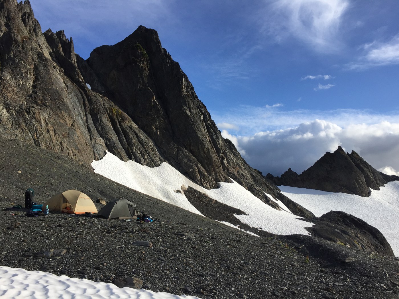
Once over the top, the route finding became much easier as we could easily spot a use trail running north from Bear Pass. Fun ridge running led us into a basin east of peak 6193. From here, you cross the ridge to your left over a small notch NE of peak 6193. At this point, you descend to a large snowfield that lies west of peak 6078. A long traverse NE along this snowfield (above huge crevasses below that you can not see) takes you to a spectacular (!!) camp at a bench south of peak 6073. Flat platform, beautiful stream, and some of the best views I have ever had at a campsite.
Day 4 started with a brief climb NE up to the east shoulder of peak 6073, at which point a use trail became obvious again. Super fun scrambling and ridge hiking brought us to the top of a peak south of Lone Tree Pass. The snowfield down was extremely steep and firm, so we skirted down on the west edge, finding an easy way down to the pass. From here, it was quick travel to the saddle between Pulitzer (peak 6283) and Ferry. The route up Ferry was easy to find, but the way off was pretty wild, with a short descent down a sketch gully.
At this point, we could see the entirety of the remainder of our route, out to Dodger Point and then down Long Ridge Trail. We found the section between Crisler's Ladder and the old CCC trail extremely hard to navigate. At the base of the ladder, you can spot a faint trail heading uphill on the right hand side of the gully. After a short distance, a broad sandy slope turns uphill. Much steep scree climbing and tree bashing follows. The 'hanging rock' tree is a bit of a joke, since the rock is tiny, and is on the OPPOSITE of the side of the tree from your approach.
After dropping the packs and doing some recon, we finally found the way, but it was a frustrating and demoralizing half hour. The CCC trail itself is wonderful and gorgeous to walk and it was quick work to Dodger Point.
Day 5 was a super fast descent down Long Ridge trail; some 14 miles to the trailhead. Trail was amazing, with no down trees, and pitched at a perfect grade. Would make for a world class mountain bike descent!
In summary, this was a fantastic trip. I found the off-trail challenging to navigate, with very few clues (cairns, etc.) along the way. Ice axe was VERY nice to have. I hiked in trail runners, as is my custom, and was fine without traction. If we had had to cross some of the snowfields in firm conditions, it would have been a bit sketchy, however, so micro spikes would have been a good addition.
Comments
Milarepa on Bailey Range Traverse, Elwha Basin, Dodger Point
Great report. As one returns from the Bailey Range towards Dodger Point via the Scott-Ludden saddle, the "Hanging Rock Tree can be spotted shortly after exiting right from the ascent up the steep gully past Crisler's Ladder. It's the most prominent tree in the area and stands alone. Here's a picture I took in 2016: http://www.communichi.org/wp-content/uploads/2018/04/hanging-tree.jpg.
Posted by:
Milarepa on Apr 29, 2018 11:15 PM