
Witness the destructive force and the restorative power of nature on this hike in the blast zone of Mount St. Helens’ 1980 eruption. The rocky ash and treeless areas are testaments to the devastation caused by the explosion, while wildflowers and shrubs signal the return of vegetation to the denuded landscape.
This hike on Boundary Trail 1 starts in a dusty, ashy area that was scorched bare by the 1980 blast. As you climb, you will see willows and small bushes that are starting to fill in the barren hillside.
In 0.9 mile, you will come to the junction with the Independence Ridge Trail (227A). Turn right and continue another 1.3 miles to the pass. Be sure to take time to survey the tree-down zone on the hillsides behind you. The parallel alignment of the ghostly-white toppled trees indicates the direction of the blast.
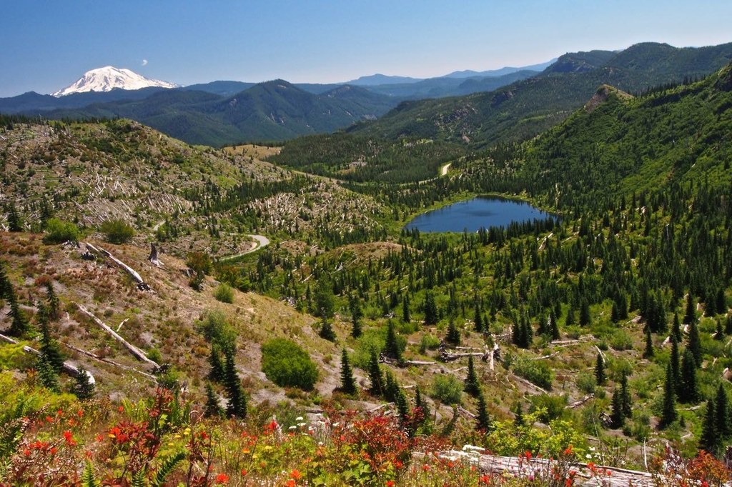
When you reach the pass, you will be treated to an awe-inspiring vista. A massive avalanche of rock debris spills from the gaping breach in Mount St. Helens’ crater onto a pumice plain, and hundreds of trees felled by the eruption float in the waters of Spirit Lake.
The pass is the perfect place to sit on a downed tree trunk, have a snack, and take in the views. There are several hiking options from Norway Pass, but the trails can be closed due to landslides. For this hike, however, retrace your steps to return to your car.
Note that there are several hiking options from Norway Pass, but the trails can be closed due to landslides. Check before you go.
WTA Pro Tip: If this is your first time here, be sure to continue on Forest Road 99 another six miles to the Windy Ridge Viewpoint for a different perspective of crater and lake. The view at the top of the stairs leading out of the parking lot is no better than the view from Norway Pass, so you can skip it. If you want to see more and you have the energy, walk up the old gravel road on the opposite side of the parking lot. In 1.8 miles, you will have a close-up view of the pumice plain at the base of the crater.
Norway Pass

-
 Length
- 4.5 miles, roundtrip
-
 Elevation Gain
- 860 feet
-
 Highest Point
- 4,500 feet
Parking Pass/Entry Fee
Northwest Forest Pass
Witness the destructive force and the restorative power of nature on this hike in the blast zone of Mount St. Helens’ 1980 eruption. The rocky ash and treeless areas are testaments to the devastation caused by the explosion, while wildflowers and shrubs signal the return of vegetation to the denuded landscape.
Continue reading
Hiking Norway Pass

WTA worked here in 2025, 2024, 2022, 2021 and 2020!
Map & Directions
 Trailhead
Before You Go
Parking Pass/Entry Fee
Northwest Forest PassWTA Pro Tip: Save a copy of our directions before you leave! App-based driving directions aren't always accurate and data connections may be unreliable as you drive to the trailhead.
Getting There
From State Highway 12 in Randle, take Hwy 131S south for 2.8 miles to FR 25. Continue on FR 25 for another 24.3 miles to the junction with FR 99. Turn right onto FR 99 towards Windy Ridge. Drive approximately 9.2 miles to FR 26 and turn right. The Norway Pass Trailhead will be .9 miles on your left on FR 26.
From Cougar, take Lewis River Road east for 2.8 miles. The road then changes to FR 90. Continue on FR 90 for 16 miles and stay to the left on FR 25, pass the Pine Creek Information Center. Drive FR 25 for 25 miles to the junction of FR 99. Turn left onto FR 99 towards Windy Ridge. Drive approximately 9.2 miles to FR 26 and turn right. The Norway Pass Trailhead will be .09 miles on your left on FR 26.


