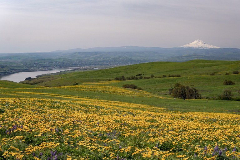
Spring Hikes in the Gorge (that Aren't Dog Mountain)
There's nowhere to park at Dog Mountain (and you need a permit to hike there on spring weekends). With all these hikes and trailheads full, how will you get your wildflower fix, or condition for your big summer hikes?
Luckily there are a lot of locations in the Gorge where you can find what you need. Gotta see flowers? Want a workout? Practicing your photography skills? We've got a few ideas for you.
Remember, no matter where you visit, it's important to follow Leave No Trace principles. Trails can handle plenty of visitors, as long as we work together to keep these areas as nice as we can — take only pictures and leave only footprints.
Get Your Wildflower Fix
Columbia Hills State Park - Stacker Butte
Length: 5 miles, roundtrip
Elevation Gain: 1,150 feet
High Point: 3,200 feet

Blooms at Columbia Hills State Park are as arresting as those at Dog Mountain, and with more trails to pick from, you're likely to leave less of an impact when you visit. Photo by MafHoney.
While the trail itself is a service road, at Stacker Butte you'll find one of the best floral arrangements nature has to offer. Bring a floral guidebook; you can expect to find balsamroot, lupine, and paintbrush, as well as phlox and desert larkspur. Once at the top, you'll be rewarded by views up and down the Gorge. Wildflowers and views in one hike? Not a bad deal.
> Plan your visit to Stacker Butte using WTA's Hiking Guide
Rowena Plateau and Tom McCall Nature Preserve
Length: 3.4 miles, roundtrip
Elevation Gain: 1,200 feet
High Point: 1,750 feet
 Rowena Plateau and the Tom McCall Nature Preserve are gorgeous for wildflowers. Photo by austineats.
If you can wait until May 1, put Rowena Plateau and Tom McCall Nature Preserve on your list. Just across the river in Oregon, this area has lovely views downriver, the flowers are stunning; even the road is a joy! It was originally designed for touring, so the grade and curves are optimized for a pleasant experience.
> Plan your visit to Rowena Plateau and Tom McCall Nature Preserve using WTA's Hiking Guide
Lyle Cherry Orchard
Length: 5.0 miles roundtrip
Elevation Gain: 1,050 feet
High Point: 1,100 feet
 Dramatic views and lots of wildflowers await hikers at Lyle Cherry Orchard. Photo by Patricia Coulthard.
Lined with camas, grass widows, larkspurs, glacier lilies, shooting stars, locoweed and balsamroot, Lyle Cherry Orchard boasts a myriad of wildflowers, and views to boot! This stunning preserve is owned by the Friends of the Columbia Gorge and tops out in an old cherry orchard with a few surviving trees. WTA has been hard at work here building new trail, so you have even more miles of wandering to enjoy here.
> Plan your visit to Lyle Cherry Orchard using WTA's Hiking Guide
Work Up A Sweat
Hamilton Mountain
Length: 7.5 miles, roundtrip
Elevation Gain: 2,000 feet
High Point: 2,400 feet

Views and a great workout -- what more could you want from a hike? Photo by jar.berg.
While Hamilton Mountain offers a workout, it is also full of the best things the Columbia Gorge has to offer: easy access and parking, a well-maintained trail, wildflowers galore, two waterfalls, and views to knock your sweaty socks off. Try it, and you may discover your new go-to trainer in the Gorge.
> Plan your visit to Hamilton Mountain using WTA's Hiking Guide
Table Mountain
Length: 16.0 miles, roundtrip
Elevation Gain: 3,350 feet
High Point: 3,417 feet

Even if it's cloudy at the top, Table Mountain is a dramatic location. Photo by maxjames.
This one's a commitment. The locally-known trailhead is now on private land and closed to the public, so you'll need to access Table Mountain via the Bonneville Trailhead, making the hike twice as long as it used to be. It's a test of endurance, but the views from the summit make it worth it, as do the views along the way.
> Plan your visit to Table Mountain using WTA's Hiking Guide
Starway
Length: 11.0 miles, roundtrip
Elevation Gain: 2,377 feet
High Point: 3,977 feet

Starway is also a good fall destination, once the foliage has reddened. Photo by Anna Roth.
While it's not quite in the Gorge, views from the summit of Starway are stellar, and it's a heck of a hike to get to them. You also might need to borrow a car, since you definitely need high-clearance here. The road is pretty gnarly, but for a quiet route to a summit with views of five volcanoes, it's worth it.
> Plan your visit to Starway using WTA's Hiking Guide
Get the Shot
Mosier Twin Tunnels
Length: 9.4 miles, roundtrip
Elevation Gain: 730 feet
High Point: 540 feet

The views and the landscape at Mosier Twin Tunnels make is a don't-miss Gorge destination. Photo by CiscoKitty.
Lucky for hikers, the Historic Columbia River Highway, which used to have some of the most scenic views in the Gorge, has been transformed into a paved walkway. Now, you can hone your photography skills here on a low-key ramble, whether you're shooting macros of flowers or panoramic views of the Gorge.
> Plan your visit to Mosier Twin Tunnels using WTA's Hiking Guide
Cape Horn
Length: 7.7 miles, roundtrip
Elevation Gain: 1300 feet
High Point: 1500 feet

Cape Horn is a go-to spot in the Gorge. Photo by Carolina Cano.
The views here are absolutely incredible, and the trails are improved by WTA crews, so you can step surefooted while you're gawking at the scenery. Take note of the peregrine falcon nesting closure — this can be done as a loop in the winter, but it's gotta be an out and back during the spring.

