
When looking for solitude or a quiet, cool creek to ramble along, look no further than Canyon Creek. This trail’s gentle tread and easy grade were cut long ago for horse-pack trains. Along this old supply route to the mines there are numerous babbling brooks, and other natural wonders to keep you entertained. Once this river trail could be followed all the way to Chancellor and then into the Pasayten Wilderness or towards Harts Pass. Alas, wash outs now close the trail five miles in at Mill Creek.
This is a fabulous trail for families as the first few hundred yards are open forest which is well shaded and runs alongside the rocky Granite Creek. Soon after departing the trailhead, there is a large bridge to cross the river.
After a few hundred yards, the trail bifurcates, the right branch taking the Chancellor Trail (Canyon Creek) and the left heading to Jackita Ridge and Crater Mountain. It is worth taking a small detour downt the left fork a short ways to the beautifully built Beebe Cabin. Originally built by three shipwrights it was moved to this location in the 30s and used as a guard station.
Back at the intersection ascend the right hand fork. The trail quickly steps up the side of an old lateral moraine and then another a short distance beyond the first. Note the long even slope and imagine how it was formed by glaciers thousands of years ago.
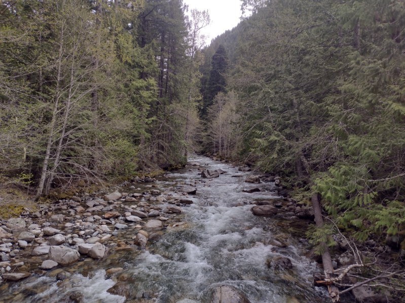
At the top of the moraine sits a fine camp site. Beyond this, the trails' grade eases and the noise of Highway 20 is drowned out by the river's crashing below. The trail’s gradual climb side-hills above Canyon Creek hundreds of feet below. Occasional old-growth trees dot the hillside, but mostly the needle-rich, soft duff trail just winds off into the distance.
Trail runners will enjoy the gentle grade and almost complete lack of rocks. Keep your eyes open and old side trails, most likely left by miners, will become apparent. At almost two miles one of these on the left traverses to Rowsley’s Chasm. Its sign is broken but as of this writing, the phrase “closed to horses” remains. Venture down this trail for a thrilling look into a hole but keep pets and children close by, a slip will be fatal.
Continuing along, the hillside gets steeper and rock outcroppings are rounded. Watch for old blasting holes on the outside corners where rock was removed to create this old pack trail. Side creeks become more frequent and water is generally available at Discovery Creek about 2.5 miles from the trail head.
The cool forest here is full of stair-step moss, twin flower, and many other fun plants. Lipstick lichen, also known as British Soldier lichen for its bright red caps is prolific along this trail. Boulder Creek is reached at around 3.5 miles after a descent of several hundred feet. Look for a great bench on the river's southern bank for camping. The trail continues on but reportedly is closed at the five mile mark due to a washout.
Canyon Creek

-
 Length
- 6.0 miles, roundtrip
-
 Elevation Gain
- 1,994 feet
-
 Highest Point
- 2,732 feet
Highway 20 is closed between the Ross Dam trailhead (milepost 134) and Silver Star gate (milepost 171) for the winter season.
Parking Pass/Entry Fee
Northwest Forest Pass
When looking for solitude or a quiet, cool creek to ramble along, look no further than Canyon Creek. This trail’s gentle tread and easy grade were cut long ago for horse-pack trains. Along this old supply route to the mines there are numerous babbling brooks, and other natural wonders to keep you entertained. Once this river trail could be followed all the way to Chancellor and then into the Pasayten Wilderness or towards Harts Pass. Alas, wash outs now close the trail five miles in at Mill Creek.
Continue reading
Hiking Canyon Creek

WTA worked here in 2015, 2011, 2006 and 2005!
Map & Directions
 Trailhead
Before You Go
Highway 20 is closed between the Ross Dam trailhead (milepost 134) and Silver Star gate (milepost 171) for the winter season.
Parking Pass/Entry Fee
Northwest Forest PassWTA Pro Tip: Save a copy of our directions before you leave! App-based driving directions aren't always accurate and data connections may be unreliable as you drive to the trailhead.


