

*Consider visiting Blanca Lake on a weekday. There is parking available here for about 20 cars, but the lake's popularity, particularly on weekends, often results in far too many cars for the small lot and access road. Please park so that cars and horse trailers can get in and out of the lot.*
Visit one of the most striking lakes in the Henry M. Jackson wilderness. The vibrant blue of the glacier-fed lake provides the perfect rest stop for hikers who have braved the thirty-odd, steep switchbacks that lead to the lake.
The trail starts in cool second growth forest, but the trees are quite sizable. In the fall, the squirrels roughhouse in the trees high above your head. Occasionally they drop gigantic pinecones from high above, and while the resulting crash is startling, it is fun to watch.
The trail is in excellent shape, and gets right down to business, starting off venturing through a close forest with very little understory, but lots of moss. As you climb, you move swiftly from one steep but well-designed switchback to another, and yet another, gaining a little under 3,000 feet in a little under 3 miles.
While this can be draining, rewards await you at the top. Huckleberry bushes line the trail, and tired hikers can stop and munch on the sweet treats to their heart's content. After three miles, the trail reaches a ridgeline with a set of switchbacks heading up a rocky face. If you look to the east, some stellar views of the mountains can be seen, and on a clear day Glacier Peak graces hikers with an up-close and personal view.
Once you've conquered the ridgeline, most of your climbing is over. The trail continues much more gently through sub-alpine flower meadows that glow with lupine when in season. Eventually, the trail drops to pretty but stagnant Virgin Lake. There is no inlet or outlet, so the water is entirely snowmelt and rainwater, and by late fall the water is more like a bog. Often, this is a breeding ground for frogs and salamanders, so keep your eyes peeled for plenty of amphibian friends.
WTA trail crews have had backcountry response teams (BCRTs) working to improve this section of trail for three summers, but use caution in wet weather as small sections can still be muddy, rocky, rooty, and steep, dropping 600 feet in 0.6 miles.
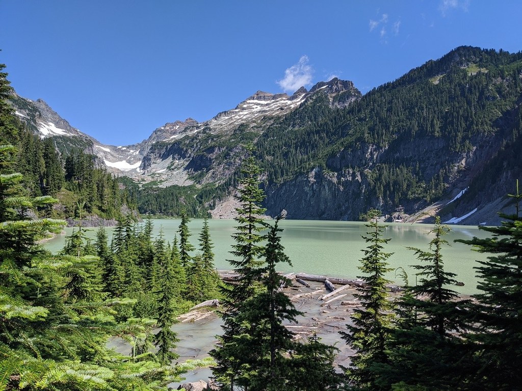
If you can tear your eyes away from the trail, the view will take your breath away. Across the valley is the foot of Columbia Peak, and as you round the last point, beautiful Blanca Lake opens up in all her glory. The lake is framed to the north by the peaks of Monte Cristo, Columbia, and Keyes. More than a few hikers have been known to gasp aloud when they round the corner and see the robin-egg blue waters.
Above the lake, the Columbia Glacier drains via a twin waterfall into the vibrantly blue-colored water. It's the glacial till in the water that lends the lake its otherworldly color. 0.2 miles before the lakeshore, there is a nice viewpoint to take a perfect photo with Blanca Lake in the background. At the end of the trail lies a small beach full of driftwood, perfect for relaxing and enjoying the beauty that surrounds you. It may be tempting to pitch a tent here, but camping within a half-mile of Blanca Lake is prohibited by Forest Service (as of May 1, 2021). Camping is allowed at Virgin Lake and on the ridge above Virgin Lake.
Here pikas and marmots abound, watching like sentinels from large boulders fallen from the peaks high above.
WTA Pro Tip: Blanca Lake is an extremely popular trail. If you decide to visit, you can enjoy a quieter destination by heading for Toil Peak, attainable from the saddle just above Virgin Lake. Instead of heading downhill toward Virgin and Blanca Lakes, head up and west for views of Glacier, Kyes and Monte Cristo Peaks, as well as Blanca Lake's robin-egg blue glowing in all its glory.

 Trailhead


