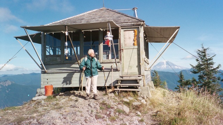
You are here: Home Find a Hike Hiking Guide Burley Mountain

Burley Mountain

» REI » Amazon

A portion of all book sales from the links above benefits WTA and helps protect and maintain our trails.

This is an easy walk up to a picturesque fire lookout. Along the way, you'll find huckleberries in abundance along the track, and views that get increasingly better as you climb the slight grade. You have the option of hiking the old dirt road, or following a short trail that loops around the other side of the peak on its way to the summit. Either way, the views are grand and the walking is easy and highly enjoyable.

Start up the dirt track of the spur road, enjoying a pleasant forest hike. After about 0.25 mile, your options double: You can stay on the road as it swings right into one long switchback to climb to the lookout atop the summit. (This way is easier walking for small legs and chatty hikers since two hikers can walk abreast.) Or you can go left onto a small single-track trail that swings out along the northern side of the mountain before attaining the summit.

Both options entail a half-mile of walking, and both offer the same bounty of huckleberry bushes and glorious views. Your best bet? Choose one track for the way up, and the other for the way down.
Driving Directions:

From Randle, drive 1 mile south on Forest Road 25 and then turn left (east) onto FR 23 (Cispus Road). Continue on FR 23 to its junction with FR 28/21. Bear right on FR 28/21, cross the Cispus River, turn right onto FR 76, and continue past the Cispus Environmental Center to FR 77 on the left. Follow FR 77 for about 7.5 miles, then turn left onto the dirt track of FR 7605. The trailhead is found in another 1.5 miles at the start of Spur Road 7605-086.

Improve or add to this guidebook entry

Note: the description and driving directions for this Mountaineers Books entry are copyrighted and can't be changed.

Recent Trip Reports

Hiked here recently? Submit a trip report!
There are 5 trip reports for this hike.
Burley Mountain — Aug 03, 2009 — Dick Morrison
Overnight
Features: Ripe berries
Expand report text Hide report text
This was a lookout maintenance trip. We replaced windows and the shutters on the east side of the b...
This was a lookout maintenance trip. We replaced windows and the shutters on the east side of the building. There is a fairly large fire on the next ridge east, about a mile and a half from the lookout! The lookout is now white, and the new paint will help preserve the building! The huckleberries are starting to get ripe!
Read full report with photos
Burley Mountain — Sep 03, 2008 — EckartS
Day hike
Features: Ripe berries
Expand report text Hide report text
Burley Mountain Lookout, south of Randle in the Gifford Pinchot National Forest, is a drive-up. Unf...
Burley Mountain Lookout, south of Randle in the Gifford Pinchot National Forest, is a drive-up. Unfortunately, because that does not do the cleanliness of the lookout tower any good. The interior of the tower is badly trashed. Access to the building should be more closely controlled. Spur 086 should be gated at the saddle where Trail 256A starts.
We decided to walk instead of drive FR 7605 from its junction with FR77 and Spur 152 to its junction with Spur 086 and then continued on Spur 086 to the start of Trail 256A because our car could not handle steep and rutted logging roads. At the saddle below the peak is a small parking area and a bulletin board without any bulletins. The view from here is already quite good. The gate that should prevent unauthorized vehicles from driving any further is in bad repair. Trail 256A is a rarely hiked, unsigned, faint zigzag trail through the pumice slopes and huckleberry bushes and re-joins the road close to the summit. There is a good picnic table next to the lookout tower and there are several antenna installations. The view is grandiose, including Mt. Adams, Mt. St. Helens and of course Mt. Rainier. In addition, the Cowlitz River valley lies at your feet and the Goat Rocks form the horizon to the East. We waved across to Langille Ridge, Tongue Mtn. and Juniper Ridge, familiar territory where we had hiked in previous years.

The old Trips and Trails 2 book (3rd. Ed. 1983, Reprint 1987) described the ridge as being a popular destination for huckleberry pickers in the fall. However, except for the immediate vicinity within one mile of the lookout tower, the ridge between here and Polepatch/Mosquito Meadows has now all grown trees and no longer supports any huckleberries. The continuation of FR77 towards Polepatch is blocked by a washout.

6 miles R.T., 1.5 h up, 1.2 h down, Elev. gain 1250 ft., Max. elev. 5310 ft.
Read full report with photos
Burley Mountain #256 — Nov 19, 2004 — D. Inscho
Day hike
Expand report text Hide report text
What a wonderful surprise to wake up and find myself surrounded by volcanoes, one of which is still...

What a wonderful surprise to wake up and find myself surrounded by volcanoes, one of which is still breathing. With the forecasted break in the weather I decided to venture into a new neighborhood. What better vantage could there be than three walls of glass on a summit, especially with these potentially frosty November days.

Proper balance was struck for this “Multiple Abuse” destination: enough snow to close the road, but not enough to encourage raging snowmobilers and their oily fumes. The LO road is gated. I arrived at snowline to flurries and wonderful cold. My dog Ceili cares little of volcanoes, but is always thrilled to venture into winter, especially 12” of powder. Trees bore festive loads of snow as I skied upward on the road. There was enough clearing to allow a teaser view of Tahoma, but it socked in for much of the night. Rime crusted everything on the summit, including the repeater towers. Lows down to 22F at night.

Faith in the forecast paid off as clouds drained into the valleys revealing a collection of Cascade volcanoes: Tahoma to the N, Adams to the E, St. Helens to the S, and Hood to the SSE. Goat Rocks Wilderness was a prominent wall of white rock to the ENE. The Silver brook facility in Randle was lit up all night long rendering trees into neat stacks of lumber.

My LO routine has me arising about an hour before sunrise to melt snow for coffee and get something to eat. Scrambling at first light, 7:24, I grabbed up images with frozen fingers. The rest of the day is spent with leisurely chores, writing, siesta, tea, and maybe a mid-day ramble for snow shots. This late-season sunshine creates long blue shadows all day long. The latter part of the afternoon is spent sipping wine, eating mountain steak (jerky), and watching light before the final flurry of picture making. Sunset at 4:28, enjoyed while walking a snow-covered ridge in peachy light, breathing-in the freshness and silence.

Saturday a couple of hunters prowled about for deer with their rifles. They took a pointed interest in my mountaintop residence via binoculars. They were less than two hundred meters away but did not approach as most would, instead peeping over the ridge; this made me uneasy. The second night I saw a searchlight swinging about on a forest service road below at about 1a. Minutes later shots rang out, poachers shining deer? Reminds me of fish-stick, tartar-sauce “sportsmen” raking hooks through the water after salmon, declaring triumph after landing a belly-hooked fish.

This LO has seen some hard use. Two windows are broken making it a bit drafty. The east shutters have been ripped off by storms due to being improperly secured; the windows are now boarded over with plywood. The interior was not very hygienic with evidence of a rodent problem; the cabinet drawers smelled of mouse urine. Cleaning helped somewhat.

What to say, the Cascades keep on giving! So hard to surrender such a landscape to hedonistic hibernation, to sleeping in one’s own bed, to indoor plumbing, to conveniences blocks away. Such a winter-long sentence will be whiled away gathering maps and searching the contour lines for passage, for self-discovery, for redemption. In the words of Ed Abbey “May your trails be lonesome, stony, narrow, and only slightly uphill…”

Read full report
Burley Mountain #256 — Sep 19, 2004 — D. Inscho
Day hike
Expand report text Hide report text
The drive from High Rock to Burley Mountain takes one through the heart of Big Timber country. Inde...

The drive from High Rock to Burley Mountain takes one through the heart of Big Timber country. Indeed, evidence of their chainsaw massacre was everywhere. This access road is steep and long, but in ok shape for the most part. There is a soft, deep, muddy section at about 3800’ beneath a current cutting operation; I was barely able to get through in 2wd with high clearance.

The summit is a repeater station for the Forest Service and was enveloped in clouds and showers. There were also several bow hunters about, blowing synthetic calls to their elk quarry. The trail looks barely used since the road has gone in.

I was thinking this could be a winter X-country ski destination, but the lack of any protections makes this a haven for the winter razzer crowd.

Read full report
Burley Mountain #256,Angel Falls Loop #228.2 — Jun 08, 2002 — Sore Feet
Day hike
Issues: Mudholes | Water on trail
Expand report text Hide report text
After not being able to hike various locations in the American River area due to SNOW IN JUNE, I to...

After not being able to hike various locations in the American River area due to SNOW IN JUNE, I took up the Covell Creek Falls / Angel Falls loop near High Rock instead. Being pleasantly surprised by a massively high Grant Purcell Falls at La Wis Wis, I hoped Covell Creek was running at it's peak too, or at least higher than the garden hose volume it was at last time I visited.

There are two ways to access this trail, one leaves from the Cispus Learning Center, just off FR 28, 13 miles southeast of Randle, the one I took starts out at the Burley Mountain trailhead off of FR 28 itself, about 4 miles from the FR 23 / 28 intersection.

The trail starts out climbing away from the road at a rather steep clip and switches back up the hill to a juntion at 1/2 mile. From here, signs direct you to Angel Falls and Covell Creek Falls (labeled just 'waterfall' on the trailsigns). I decided to get the ugly part out of the way first, so I went to Covell Creek.

In the 1/2 mile from the intersection to the falls, the trail skirts almost constant cliffs of Basalt towering over 200 feet above the trail, often overhanging the trail, sprouting cities of ferns and mosses. Shading the trail on the downhill side is ubiquitous vine maples, and between the cliffs, ferns, mosses, and trees, this is a really pretty section of trail, which is further enhanced by what looks like old lava tube style caves that are slowly being dug out by freeze & thaw style cleavage.

Covell Creek Falls is reached 1 mile from the road, and I guarantee you won't forget it. The trail dives behind the wall of water, or in the case of the late summer, the thin fountain-like streams coming off the 75 foot basalt face. The only full trailside views of the falls are on the far side of the creek, but the best views are from directly in front of the falls (there is an obvious boot path leading downstream, right next to the falling water).

After the falls, the trail climbs again, this time MUCH steeper, not unlike the Wahkeena Creek trail in the Columbia Gorge (only not as wide or well graded). After another 1/2 mile of walking, and 200 feet of climbing, the trail levels and splits. The trail to Burley Mountain continues uphill, and Angel Falls lies downhill. Guess which way I went? (btw, the sign marking Angel Falls at this juntion is really cool)

Another 1/4 mile downhill leads to the base of 175 foot Angel Falls. And much to my delight, there was actually water in it this time. I had visited the falls twice before, and both times there was not much more liquid than I can spit. This time, there was a rather sizable stream, pleasantly skipping down the mossy rocks. Really, one of the most attractive waterfalls I've seen in a long time. So I took a little time here (not just because my legs were liquifying).

After I finished basking in the fine mist, I headed back to the car. Just after crossing Angel Falls' stream, you cross the mainstem of Covell Creek, then it's an easy, flat (my favorite part) 1/4 mile to the first trail junction, and another 1/2 mile downhill to the trailhead.

Do this hike now, the creek will start shriveling very soon.

Read full report
burley mountain lookout - EckartS
Burley Mountain lookout. Photo: EckartS
Location
Burley Mountain (#256)
South Cascades -- Dark Divide
Gifford-Pinchot National Forest, Cowlitz Valley Ranger District
Statistics
Roundtrip 1.5 miles
Elevation Gain 400 ft
Highest Point 5304 ft
Features
Mountain views
Summits
User info
Good for kids
Northwest Forest Pass required
Guidebooks & Maps
South Cascades
Green Trails No. 333 McCoy Peak

Improve or add to this guidebook entry

Note: the description and driving directions for this Mountaineers Books entry are copyrighted and can't be changed.

Map it
Red MarkerBurley Mountain
46.39985 -121.8702
(46.3999, -121.8702) Open in new window
Document Actions
  • Email this page
  • Print this
  • Share

Mountaineers three booksSelect content from The Mountaineers Books' guidebooks is featured in this Hiking Guide. Sales of the books from this website help protect and maintain trails.

> Shop Now

More hikes » Hike of the Week
Ingalls Creek

Ingalls Creek

Central Cascades

This trail is a true springtime gem for hikers and backpackers. Walk beside a raging whitewater creek swollen with snowmelt, enjoy the blooms of wildflowers and gaze up at the Stuart range.

Get Trail News

Subscribe to our free email newsletter for hiking news, events, gear reviews and more.

What's Happening
Hike the State Jun 06, 2012 It's like speed dating, for trails. 7 Regions, 7 Experts, 7 Minutes....Go!
More »