The Carbon Glacier is a dramatic expanse of slow-moving ice beneath the shadow of Mount Rainier’s north face. While the glacier sits at a relatively low elevation, the approach is long due to the additional 5 miles of road that must be walked or biked to reach the trailhead. The trail to reach the glacier is equally as exciting as the scenery along the way, including seasonal foot logs and a suspension bridge over the raging Carbon River.
The trail starts in the luxuriant montane rainforest of the Carbon River Valley. Everything here is covered in moss, dripping with condensation on cool days, and moderating the heat in summer. At a quarter-mile the trail comes to a creek that has been overtaken by a channel of the Carbon River. It is slowly taking away the bank and making it hard to keep a bridge installed here.
Immediately beyond the crossing is a 200-foot side trail to Ipsut Falls, a narrow cascade squeezed between two walls. Continue left and uphill, soon arriving at another junction, this time the Ipsut Pass Trail, which climbs steeply to the right. For Carbon Glacier, stay left on what is now the Wonderland Trail, the famed loop around Mount Rainier. The trail now rises up above the valley floor, with views onto the growing channel and its destruction in the forest.
Soon the trail uses a series of log bridges over the wreckage from former floods before arriving back into the forest where a flat, pleasant trail covered in hemlock cones leads through mossy old growth near the river. The hiker can hear the sound of rocks tumbling along the river bottom during periods of heavy flow. The trail then traverses an open slope beneath avalanche chutes choked with salmonberry and vine maple.
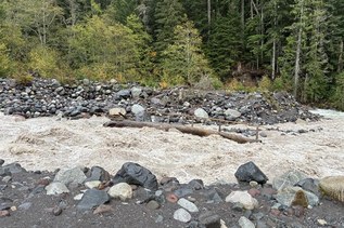
At 2.0 miles the trail swings around a rocky rib and suddenly meets a washout that forces the Wonderland Trail to switch banks. The only way to Carbon Glacier now is to descend here and cross the log bridge that is seasonally maintained over the western channel of the Carbon River. After crossing, follow cairns nearly due east to the opposite side of the wide valley bottom where the other channels flow. A great glimpse of Mount Rainier is offered midway across the floodplain.
Upon the far bank the trail re-enters relatively cool old growth forest and ascends via switchback to a junction with the Northern Loop Trail. Stay right for the Carbon Glacier, crossing several small creeks along the way. The last mile is a pleasant, gradual gain of 400 feet under mossy old growth that tower over the open understory and a few cliffs.
At 3.5 miles reach a junction with the trail to Seattle and Spray Parks, destinations that are more easily reached from Mowich Lake. It is worthwhile, of course, to inspect the exhilarating suspension bridge that spans the Carbon River, where a fine view of the Carbon Glacier can be seen from the bouncy wooden plank deck. Better views of the glacier and Mount Rainier lie farther on, however.
Continue on the Wonderland Trail just a half mile more for the best views. As the trail climbs beneath tall cliffs on the left, the full north face of Mount Rainier comes out over the Carbon Glacier. Willis Wall rises stark and cold above the icy humps of the Carbon Glacier, the Carbon River itself issuing straight form its dirty, rubble covered snout. The glacier is the lowest permanent ice in the United States outside of Alaska. It is the thickest glacier at the park, and while it is not receding, it is losing mass by, essentially, deflation.
Carbon Glacier

-
 Length
- 18.4 miles, roundtrip
-
 Elevation Gain
- 1,800 feet
-
 Highest Point
- 3,500 feet
The Fairfax Bridge (3 miles south of Carbonado) is closed to all vehicle and pedestrian traffic until further notice due to safety concerns. The bridge closure renders this hike inaccessible.
Parking Pass/Entry Fee
National Park Pass
The Carbon Glacier is a dramatic expanse of slow-moving ice beneath the shadow of Mount Rainier’s north face. While the glacier sits at a relatively low elevation, the approach is long due to the additional 5 miles of road that must be walked or biked to reach the trailhead. The trail to reach the glacier is equally as exciting as the scenery along the way, including seasonal foot logs and a suspension bridge over the raging Carbon River.
Continue reading
Hiking Carbon Glacier

WTA worked here in 2015, 2014 and 2013!
Map & Directions
 Trailhead
Before You Go
The Fairfax Bridge (3 miles south of Carbonado) is closed to all vehicle and pedestrian traffic until further notice due to safety concerns. The bridge closure renders this hike inaccessible.
Parking Pass/Entry Fee
National Park PassWTA Pro Tip: Save a copy of our directions before you leave! App-based driving directions aren't always accurate and data connections may be unreliable as you drive to the trailhead.
Getting There
From Buckley, head south on WA-165 for 1.6 miles. Turn left and stay on highway 165, passing Wilkeson and crossing the the Carbon River Bridge before turning left toward Carbon River at 10.3 miles. Continue another 7.7 miles to the end of the road at Mount Rainier National Park, 18.0 miles from Buckley.
Parking for a dozen vehicles. Indoor toilets on the river side, opposite the rain forest loop trail. Carbon Glacier Trail starts after hiking or biking the 5 miles of abandoned Carbon River Road to Ipsut Creek Campground. Toilets, information board, and bike rails at trailhead. Both Carbonado and Wilkeson have saloons that offer food service.