

Day-hikers and backpackers alike visit Lake Dorothy, a very large and beautiful lake less than two miles from the trailhead. Once there, they either rest and play for the day, or continue on to Bear and Deer Lakes, a pair of very pretty smaller lakes deeper in the Alpine Lakes Wilderness. The very ambitious press on to remote Snoqualmie Lake. Lake Dorothy can be crowded on summer weekends, but the other lakes see fewer visitors.
Sign in at the trailhead and begin your hike. You'll find the trail to Lake Dorothy generally in good condition, with many sections stabilized by carefully-assembled log cribs. It's about 1.9 miles to the lake, with an 800 foot elevation gain. After the first mile, come to a crossing of Camp Robber Creek. Pause there on the sturdy bridge to appreciate the whitewater rapids, and to enjoy the welcome (in summer) breeze that often blows down the canyon.
Then continue on up the trail, encountering additional log cribs. When you reach the outlet of Lake Dorothy, a sign offers the choices of "Outlet Spur" straight ahead, or "Inlet" and "Bear Lake" to the left.
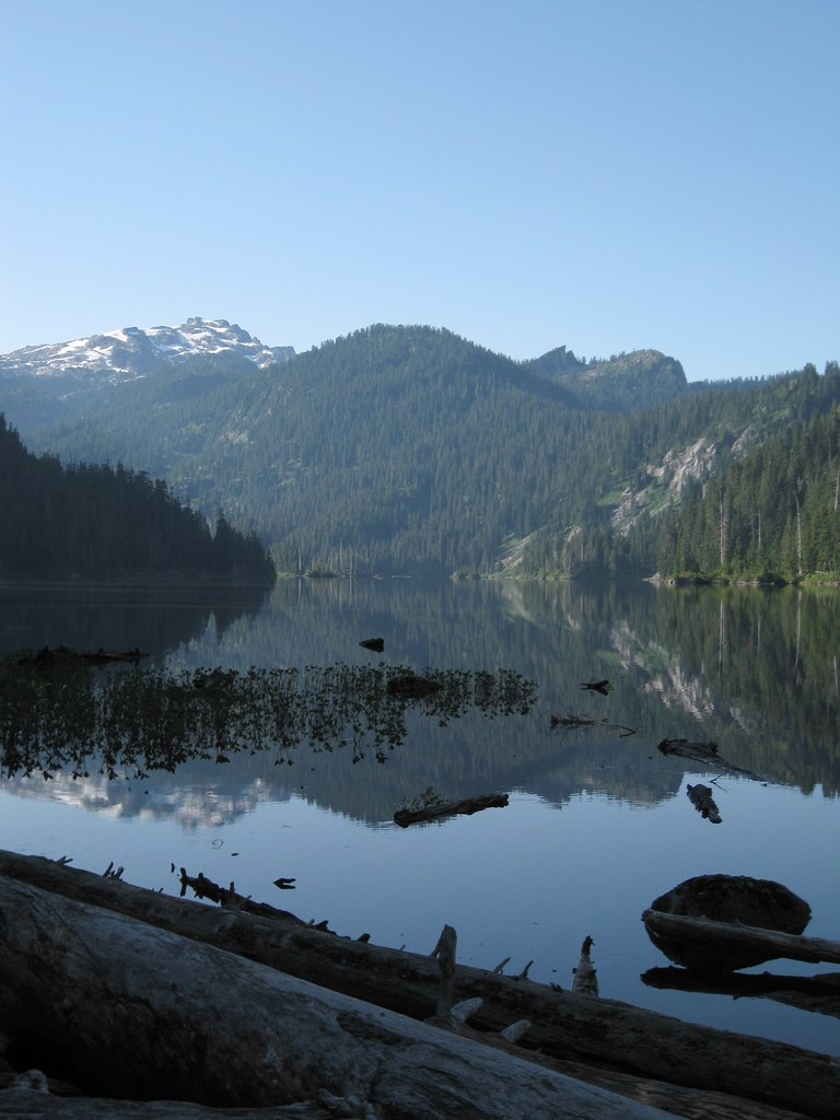
Whatever your plans are for the day, begin with the Outlet Spur. In about 100 yards it passes a log jam at the outlet of the lake. Some of the logs are quite large and have been firmly in place for many years. Look carefully and if you feel comfortable, walk carefully a few feet out onto the logs, as many others have done before you. The reward is the best view of Lake Dorothy you will find, looking up the entire 1.5 mile length of the lake with a view of Big Snow Mountain beyond. It's a great photo op, particularly if you arrive early in the morning while the sun still is fairly low in the eastern sky.
Then check the creek downstream of the log jam. The outflow is initially very tranquil, and sometimes a dipper bird may be seen foraging in the shallow water.
If you plan to go on to Bear Lake, or are seeking a campsite, or are just exploring farther along Lake Dorothy, return to the trail junction. In summer, there is often a posting showing the locations of many camp sites (and a few backcountry toilets) along the eastern and southern shores of the lake.
Take the trail toward the Inlet and Bear Lake, but don't expect it to be a lakeshore stroll, for much of the way the route is well above lake level. Occasional paths descend to reach campsites on benches above the lake or sites down at the lakeshore. The route alternates between forested and rocky stretches, and there is some up and down.
If you are hiking in August, be alert as you pass bushes along the trail. You are likely to find ripe blueberries edging the trail.
After hiking 1.8 miles from the outlet, come to Lake Dorothy's inlet stream. There is no bridge, but in summer the stream can generally be crossed on boulders, though trekking poles may be helpful for balance.
Near the southern end of Lake Dorothy, an occasional tall, dead tree offers a perch for ospreys that forage there for fish. Eagles may be seen too.
If your plans are for Bear Lake, get ready for some uphill. You'll gain 700 feet in 1.6 miles, on sometimes rough trail to reach the pass to Bear Lake. But the way is eased by occasional enjoyable views down to Lake Dorothy.
A short way beyond the pass Bear Lake can be seen glinting through the trees. But the trail takes its time getting you there. It's a half-mile with a drop of 200 feet to get down to the western shore of the lake. This is a nice place to sit a while, relax and have a snack. It's over 5.5 miles from the trailhead, so Bear Lake is the turn-around point for many day-hikers.
Deer Lake, a twin of Bear Lake, is not far away. It's only 30 feet lower than Bear Lake, and going there adds less than a mile to your round trip. At one point along the ongoing trail, bits of both lakes will be visible through the trees, so you can check out Deer Lake without going all the way there.
If you are backpacking, there are possible campsites along the western shores of Bear Lake and Deer Lake. Also, a path leaving the main trail between the two lakes heads toward a bench between them, and you could investigate that area for additional camping opportunities.
Extending Your Hike
The trail continues on beyond Deer Lake toward Snoqualmie Lake, itself a large, beautiful and isolated lake in a forested setting. It's just over a mile from Deer Lake, but there is a downside - literally. Snoqualmie Lake is less than 100 feet higher than Lake Dorothy, and to visit it you have to descend about 500 feet, elevation you'll have to regain on your return. So check your time and assess your energy. If it seems feasible and your interest is high, go for it.
A short way beyond Deer Lake, cross a low ridge and soon you will see part of Snoqualmie Lake down below. The view is deceptive. The lake looks very close, but it will take longer than you imagine to work your way down the steep switchbacks and around to the north end, where the trail finally reaches lake level.
But, once you are there, enjoy the sandy beach and the great lunch rock that offers a commanding view down the lake. It's a place to relax, and to reflect that you are over seven miles from your trailhead. There is an optional southern approach to Snoqualmie Lake along the Taylor River, but that's an even more imposing hike of 8.3 miles.
If you are a backpacker, you can find a few campsites along the north end of Snoqualmie Lake. If you are visiting on a weekday you might have the lake all to yourself.

 Trailhead


