You are here: Home Find a Hike Hiking Guide Silver Star Mountain - Ed's Trail

Silver Star Mountain - Ed's Trail

 
There are two routes up the north side of Silver Star Mountain that in good conditions can be combined to form a sort of loop. Along the way, hikers will be delighted with a diverse array of wildflowers, a natural arch, volcanic views and fine hiking. Spring brings colorful wildflower displays, but also crowds, especially on the weekends. Fall colors are another popular attraction. The best months to hike are May through November.

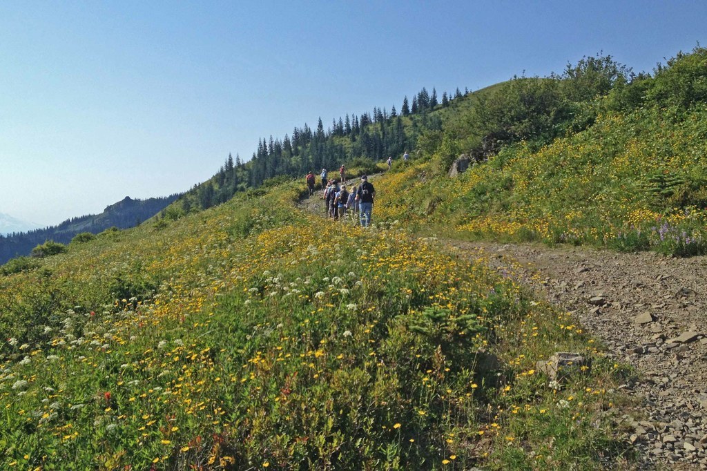
Ed's Trail is the more scenic and more rugged of the two paths up Silver Star, which can be hiked in a sort of loop. A popular way to visit the summit is to ascend on Ed's Trail and return via the Silver Star Trail. With rocky outcrops and a natural rock archway and meadows that burst with wildflowers in the spring, this trail highlights the high country that inspired the late Ed Robertson who co-founded the Chinook Trail Association. The trail was completed in 1996 by volunteers as part of the proposed Chinook Trail, a bi-state route that encircles the rim of the Columbia River Gorge.

Start on the Silver Star Trail (180) - an old road grade that climbs fairly steeply out of the parking area. Ed's Trail is a 1.5 mile segment, but is part of a popular 5 mile hike to the Silver Star Summit, when joined with other trails in the area. From the Silver Star Trailhead, hike south for about 1 mile and stay right to begin Ed's Trail (180A), which climbs the east side of the ridge.

Ed's Trail (180A) is a foot path that takes a slightly less steep route and follows along the east side of the ridge, while the Silver Star Trail traverses the west side of the ridge. The two trails meet again about 1/4 mile from the summit at the junction with the Bluff Mt. Trail. There is a short steep section on Ed's trail that requires a bit of scrambling where a slip could be very dangerous. Avoid this route when wet or icy.

From the junction, continue uphill on the Silver Star Trail for another 1/4 mile and head left up a rocky road bed - the Silver Star Summit Trail (#180D). On a clear day, the views from the summit are sublime - Mounts Hood, Rainier and St. Helens, as well as the forested hills of the Gifford Pinchot National Forest and the Yacolt Burn State Forest.

On the return you can retrace your route or stay on the west side of the ridge on the Silver Star Trail (#180) to get back to the trailhead. You can also keep hiking from here. Several trails meet near the Silver Star summit. Hikers can follow the Chinook Trail to the Kloochman Butte Trail (#180B) to the west or the Bluff Mountain Trail (#172) to the east.
Driving Directions:

From Battleground
- Drive north on State Route 503
- Turn right on onto Rock Creek Road
- Continue 9 miles to the Moulton Falls County Park
- Just past the park, turn right on Sunset Falls Road
- Continue 7 miles to the Sunset Falls Campground
- Turn right into the campground
- Continue past the bathrooms on your left and cross the East Fork Lewis River on FS 41
- Go 3.5 miles and turn right on FR 4109, it is a sharp hairpin turn going down.
- Continue on FR 4109 (it is rugged road not suitable for low clearance cars).
- About a mile past turning off of FS 41, stay on 4109 at the intersection where Road 1100 veers off to the right.
- Continue approx. 3 miles to the trailhead.

Improve or add to this guidebook entry

Recent Trip Reports

Hiked here recently? Submit a trip report!
There are 11 trip reports for this hike. See all trip reports for this hike.
Silver Star Mountain - Ed's Trail, Silver Star Mountain — Oct 17, 2011 — el tigre
Day hike
Features: Fall foliage
Expand report text Hide report text
just a postcard-perfect Indian summer day to hike this little known gem. It's a rough road to the trailhead -...
just a postcard-perfect Indian summer day to hike this little known gem. It's a rough road to the trailhead - I would not bring a regular car here - but well worth the trip. Because of the 100 year old burn here, the views start at the trailhead and don't stop. Within 1/2 mile you're staring at Mt St Helens, Mt Rainier, Mt Adams, and Mt Hood. The hillsides were simply ablaze in yellow and red. Four weeks ago there would have been plenty of ripe huckleberries.

Me and the kids (2 and 4 years old) and the dog hiked up a little over 1 mile, to the junction with Chinook Trail, before turning around. Lots of wonderful stopping places, rocks to play on, no exposed cliffs on the main trail though Ed's trail has a few steep-looking drop offs.

I cannot imagine a nicer 'easy' hike for a beautiful fall day!
Read full report
Silver Star Mountain - Ed's Trail — Aug 14, 2011 — pnwhiker
Day hike
Features: Wildflowers blooming
Expand report text Hide report text
***Lost cell phone*** We dropped our Blackberry Bold that has a rubber case on the trail. We think we were...
***Lost cell phone***
We dropped our Blackberry Bold that has a rubber case on the trail. We think we were on Ed's trail when we did it. We stopped to get our binoculars out and we think that's when it happened. We had taken Ed's Trail up, had done the rocky scramble and gone around the corner and were about 100 yards from heading into a forested area.
If you find this phone, please contact me paula122801@aim.com

As for the trip itself, the road in was very rough, with lots of potholes. You definitely need a higher vehicle like an SUV to get in there. Directions were a bit hard to follow and spots were lacking signs, but we finally found the trail-head.
There are two trails starting from the parking lot, which I didn't see anyone mention in the trip reports. You can take either one as they both end up converging about a mile up. The trail on the left has more flowers and seemed shorter/steeper, whereas the trail on the right was still steep, but maybe a bit less steep and seemed longer.
Once you get up to the spot where you can take Ed's trail, we took that (there is a sign) to the left and walked through endless beautiful flowers! We saw the arch and then did the rocky scramble, which put us at a nice rocky overlook to stop for pictures. Then we proceeded around the bend through scattered pine trees. This is where we stopped and I think dropped our cell phone.
Then we proceeded into the forested area where we saw some remaining bear grass. Once out of the trees, we converged with the Silver Star Trail and took a left to proceed the remaining 1/4 mile to the summit. There are actually two summits, one to the left and one to the right. Both are worth visiting, but the one on the left has the canister for leaving notes, etc.
We sat long enough to enjoy a granola bar and visit with some other hikers and then began our trek down Silver Star Mountain trail. The trail is mostly an old road with lots of rocks, but easily walked through.
All-in-all, this hike had more wildflowers than I've ever seen and I would highly recommend it!
No bugs, no snow, no mud, no blowdowns.....no problems at all with the trail. (except could use some better signs!) It was kinda cloudy yesterday, so we didn't get to see the volcanoes, but the flowers held our attention plenty! And the views were still grand!
But please note that you should take more than one set of directions!!! We had printed out three different directions from various sites and we used all three!
Read full report with photos
Silver Star Mountain - Ed's Trail, Silver Star Mountain — Aug 06, 2011 — Sunrise Creek
Day hike
Features: Wildflowers blooming
Expand report text Hide report text
Our daily dose of marine air west of the Cascades means that the wildflowers on Silver Star are receiving natural...
Our daily dose of marine air west of the Cascades means that the wildflowers on Silver Star are receiving natural misting: the flowers are fresh, bright and abundant. On our hike, we identified 78 species!

The best driving approach is to use DNR's Road 1100 from Dole Valley Road for 6.5 miles to the junction with Road 4109 to the trailhead. Due to recent logging activity, the DNR road is graveled and graded. The final 2.6 miles on Road 4109 remain a driving challenge. Passenger cars can make it with careful maneuvering.

We did the standard loop hike, ascending via Ed's Trail and returning via the Silver Star Trail. Ed's Trail is snow free all the way to the junction with the Bluff Mountain Trail. It has been brushed and recently maintained by the Chinook Trail Association. The Silver Star Trail, a road-to-trail conversion, is revegetating nicely and losing that road look over long stretches.

Despite the foggy conditions on the lower part of the hike, many people were on the trail. The summit was just above the marine layer, providing a sunny lunch spot and views of the big volcanoes. It was crowded, unlike the trails, and people seemed reluctant to leave -- probably hoping for more rapid clearing before they headed down.
Read full report with photos
Tarbell Trail, Chinook, Silver Star Mountain - Ed's Trail, Kloochman Butte Trail 180B, Grouse Vista Trail 180F — Oct 31, 2010 — Ryan Ojerio
Day hike
Features: Fall foliage
Expand report text Hide report text
This is a great loop hike with a waterfall, open meadows, a rock arch, scenic vista's and a great summit...
This is a great loop hike with a waterfall, open meadows, a rock arch, scenic vista's and a great summit view. In all I think it was around 12 miles.

I set out to see how some of the views would be affected by the BPA proposal to put high transmission lines through a new corridor just west of Silver Star Mountain. Although you would see the lines along the section of the Tarbell Trail that I did, they would be very present in the views from the Kloochman Butte, Silver Star mt. and Grouse Vista trails.

I started at the Grouse Vista Trailhead and took the Tarbell Trail (DNR) for about 5 miles to Hidden Falls. Along the way you pass through a new clear-cut which is a stark contrast to the lush forest at the falls. Then I continued on to the jct of with the Kloochman Butte Trail which is also part of the Chinook Trail system.

The Kloochman Butte Trail climbs through some very pretty meadows to the north ridge of Silver Star Mountain. If you stay straight at the junction wit the Silver Star Mt. Trail, you'll end up on Ed's Trail just before the memorial to the visionary trail builder and co-founder of the Chinook Trail Association.

I followed Ed's Trail south through some patches of snow, up the rocky scramble and to the jct with the Bluff Mt. Trail. From there it is a little tricky since there are a couple of confusing intersections. I continued south past the jct for the Indian Pits spur (180E) and went on to the Grouse Vista Trail.

The Grouse Vista Trail is really an old road so it is very rocky were it has been eroded. Where the trail traverses across the ridge it is not bad, but the steeper rocky sections are not very fun. I almost slipped on looks rocks covered by wet leaves several times.

Just south west of Pyramid Rock I wandered off trail about 100 yards to the grassy ridge top to look out to the east and got a great view of Mt. Hood!

The fall colors were really nice although I missed their peak by a couple weeks I think. Along the way I met some deer hunters on Ed's Trail, I was glad to have my orange vest on!
Read full report with photos
Silver Star Mountain - Ed's Trail, Silver Star Mountain — Jul 14, 2010 — Ryan Ojerio
Day hike
Features: Wildflowers blooming
Expand report text Hide report text
We had an excellent trip with Friends of the Gorge (despite some confusion with the car caravan). Be sure you...
We had an excellent trip with Friends of the Gorge (despite some confusion with the car caravan). Be sure you take a map with you and be ready for some rough roads with large water bars. Low clearance vehicles will have to go very slow and may bottom out.

I found a great map at this DNR website: http://www.dnr.wa.gov/[…]/eng_rms_tarbell_06_full.pdf

You can also use the DNR map to navigate on a smoother gravel road. Take Dole Valley Road south and get on L1100 which intersects 4109. Then you are on the gnarly 4109 for about 1/2 the distance and the usual driving route. Don't try this without a good map or you'll get lost on the maze of DNR logging roads.

Once on the trail, all the troubles with cars and bumpy roads were forgotten, replaced with incredible vistas, snowcapped peaks and an incredible display of wildflowers. He hiked up Ed's Trail on the way up (180A) and returned on the Silver Star Trail (180). I prefer going up on Ed's trail as the rocky scramble is easier going up, than coming down. The Silver Star Trail is actually an old road grade and its surface is rocky. Hiking poles are nice to keep your feet under you as some of the rocks are about the size and shape of baseballs.

We departed the Trailhead around noon and finished up about 4:00 pm, taking our time to check out the flowers and pose for pictures at the rock arch.
Read full report with photos
silver star beargrass susan saul.jpg
Beargrass and views of Mount Adams. Photo by Susan Saul.
WTA worked here!
2010
Location
Ed's Trail (#180A)
South Cascades -- Columbia Gorge
Mount St. Helens National Volcanic Monument
Statistics
Roundtrip 5.0 miles
Elevation Gain 1240 ft
Highest Point 4390 ft
Features
Fall foliage
Wildflowers/Meadows
Mountain views
Summits
Ridges/passes
Guidebooks & Maps
Day Hiking Columbia River Gorge (Mountaineers Book) by Craig Romano
Mount St. Helens National Volcanic Monument and Administrative Area, Gifford Pinchot National Forest

Improve or add to this guidebook entry

Map it
Red Marker Silver Star Mountain - Ed's Trail
45.7672834695 -122.243328094
  • Trail Work 2010
(45.7673, -122.2433) Open in new window
Document Actions
  • Email this page
  • Print this
  • Share
Log in


Forgot your login name or password?
New user?


Email Newsletter

Get Trail News each month hiking tips, trail ideas, action alerts.

Connect with us

Facebook_icon2 twitter_icon RSS_icon

Featured Member
Footer
powered by Plone | site by Groundwire and served with clean energy