

Bypass the line of cars waiting to enter Mount Rainier National Park to visit Glacier View, a rocky ridge on National Forest land that formerly hosted a fire lookout. The trail up that ridge, Glacier View Trail, does not disappoint. At the trailhead kiosk, fill out a free use permit and briefly proceed east. The trail starts its elevation gain immediately.
Enter the Glacier View Wilderness and in a few hundred feet, encounter a sign for “Glacier View Tr. No. 267;” follow the left-pointing arrow to go north into old-growth forest of mountain hemlock, Douglas fir and red cedar. If you look carefully, ponderosa pines and subalpine fir are sprinkled about. Groundcover includes huckleberry, salmonberry, red currant, snowberry and ferns. The tread is rocky and rooty much of the way, making hiking boots essential; trekking poles are a plus.
As you huff and puff during the initial ascent, peek-a-boo views of Tahoma on the right, are a preview of what is to come. The first 0.8 mile pack in 650 feet of elevation gain. Tahoma goes into hiding, and the trail briefly curls eastward into a saddle before resuming its northward direction. There appears to be a fork to the right at one mile, but this side trail lifts you closer to a granite outcrop and dips back down to the main route. The path then drops just below 5,000 feet before zigzagging east again, then resuming its upward push 1.6 miles from the trailhead.
Along the way, especially on a foggy day, absorb the tremendous inner beauty of the Glacier View Wilderness: fungi, pearly everlasting, fireweed, Scotch bluebell, Cascade aster, arnica, paintbrush, foamflower, woodland penstemon, avalanche lilies, beargrass, lupine and larkspur adorn the route.
At 1.8 miles into the journey, three sawed log segments form a convenient spot to rest, and at 1.9 miles, there is a fork: “Glacier View Trail No. 267” officially continues to the right and down towards Lake West, Saddle Lake and Lake Helen. But you will bear north on the spur to the Glacier View Summit, climbing 300 feet over the last 0.3 mile. Heather and noble fir join the flora in these higher reaches.
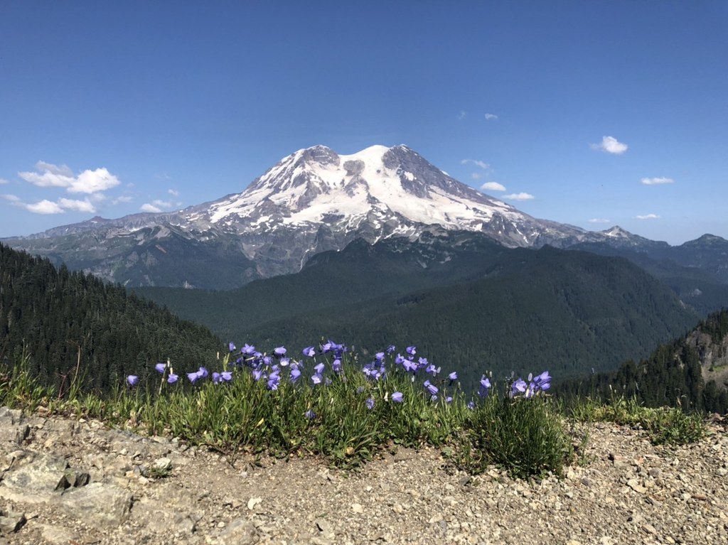
The trek terminates at a rocky outcrop 2.2 miles from the trailhead and 5,450 feet above sea level. Butterflies and moths flit and click about the summit. If the sky is clear, none of that will matter; you will be mesmerized by mighty Tahoma’s western face, dominating the horizon, 9 miles to the east.
The mountain's profile, from left to right, reveals Redstone Peak, Sluiskin Mountain, Liberty Cap, Columbia Crest, Point Success and Anvil Rock. You will have commanding views of the glaciers: North Mowich, Edmunds, South Mowich, Puyallup, Tahoma and Kautz (from left to right). To the south-southeast stands Adams. To the south-southwest stands St. Helens. Directly to your south is the rocky summit of Mount Beljica. On the clearest of days, Hood and Baker are white specks on the southern and northern horizons, respectively.
WTA Pro Tip: Budget extra time or plan to camp to complete a side trip to Lake West, Saddle Lake or Lake Helen. A superb post-hike watering hole is the Copper Creek Inn on 706, at milepost 11.

 Trailhead


