
Heybrook Lookout is a short and moderately steep hike through a fern and moss covered forest to a fun, staircase-ridden lookout with great views of the nearby mountains. If you are introducing someone to hiking, limited on time, or trying to add on another hike or activity in the area, this is the hike for you.
The trail begins in a gravel parking lot just after entering the Mt. Baker-Snoqualmie National Forest from the west. It's actually more like a glorified shoulder off Highway 2. The trailhead is located on the west side of the parking area. An information kiosk is located about 20 feet up the trail from the parking area, but there are no facilities, so make your pit stop prior to arrival.
Once on the trail, head east, paralleling the highway for a short time before turning left and heading away from the road. Remember that it's only a 1-mile hike to the lookout, so feel free to take your time; you'll be gazing up at the massive building soon enough. As you walk through the woods, enjoy the greens of the ferns and moss. Listen to the birds signing and keep an eye out for squirrels and chipmunks scurrying about. Appreciate and note the well-maintained trail, worked on almost every year by WTA trail crews.
The trail is a tranquil walk in the woods until right before you reach the lookout where you are presented a view of the mountains on the other side of the highway. You may be tempted to stay and soak in the views, but turn around and you will see the lookout; there are much better views from up there!
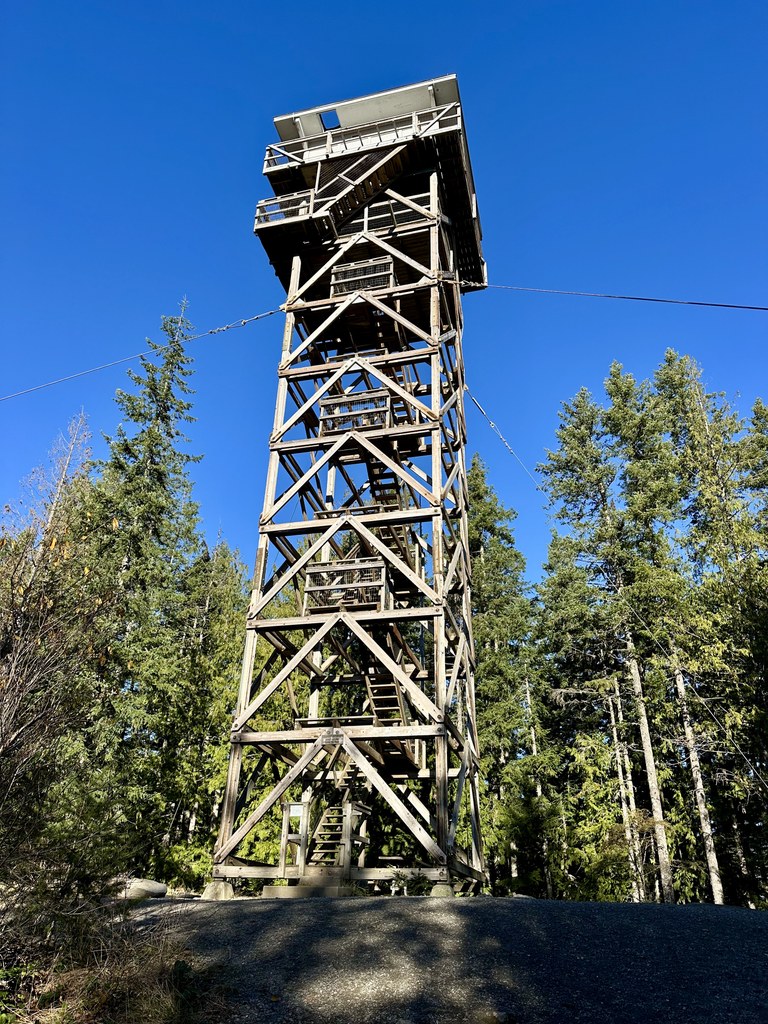
There has been a lookout at this location since 1925 with each lookout getting a little taller. The latest improvements were done by the Everett Mountaineers. Thanks to them, hikers can reap the rewards of their hard work by climbing the 89 steps to a viewing area, where you can have a snack while enjoying the views of the valley. The top floor is a cabin you can rent from the U.S. Forest Service from May through October. The cabin can be reserved on recreation.gov.
Weather permitting, you'll be able to feast your eyes on Index Mountain, Mount Persis and Mount Baring. See if you can spot Bridal Veil Falls cascading down the side of Index Mountain. For those who might be a little nervous going up those stairs to the lookout, there is a picnic table nearby that you can rest at, just be sure to ask the rest of your group to take lots of pictures so you can enjoy the view from the lookout as well.
Heybrook Lookout

-
 Length
- 2.0 miles, roundtrip
-
 Elevation Gain
- 980 feet
-
 Highest Point
- 1,800 feet
Heybrook Lookout is a short and moderately steep hike through a fern and moss covered forest to a fun, staircase-ridden lookout with great views of the nearby mountains. If you are introducing someone to hiking, limited on time, or trying to add on another hike or activity in the area, this is the hike for you.
Continue reading
Parking Pass/Entry Fee
NoneHiking Heybrook Lookout

WTA worked here in 2024, 2023, 2022, 2021 and 2018!
Map & Directions
 Trailhead
Before You Go
Parking Pass/Entry Fee
NoneWTA Pro Tip: Save a copy of our directions before you leave! App-based driving directions aren't always accurate and data connections may be unreliable as you drive to the trailhead.
Getting There
Driving from Everett, follow Highway 2 37.5 miles to the trailhead just past mile marker 37 and the sign for the Mt. Baker-Snoqualmie National Forest. The gravel parking area is on the north side of the highway. There are no toilets at this trailhead, but there is a pit toilet just past the lookout to the right.


