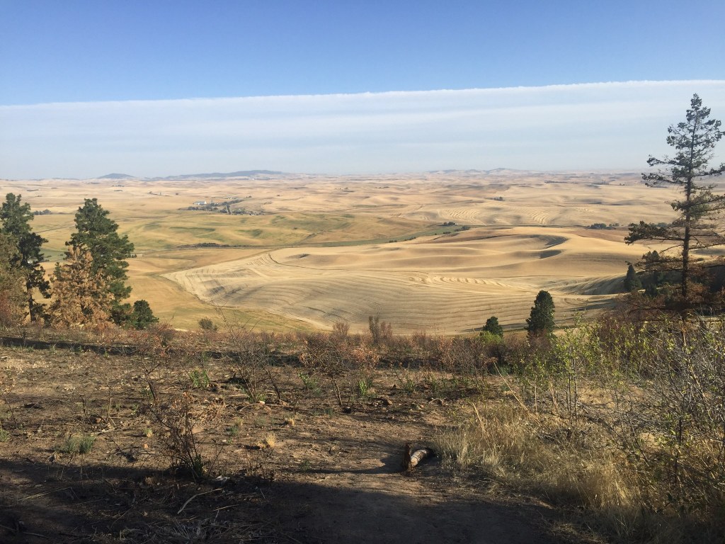
You are here: Home Find a Hike Hiking Guide Kamiak Butte

Kamiak Butte


Featured In: Best Desert Hikes: Washington, by Dan Nelson and Alan Bauer.
Buy the full book, including maps, elevation profiles, photos, and more:

» REI » Amazon

A portion of all book sales from the links above benefits WTA and helps protect and maintain our trails.

Kamiak Butte stands like an island in the rolling wheat fields of the Palouse country--not merely a physical island of rock jutting up above the fertile soils of the Palouse hills but also an "ecosystem island."

The dry butte supports a rich sage desert ecosystem on its southeastern face, with a lush forest--ponderosa pine, Douglas fir, grand fir, even some cedar--on its north face. This combination of vegetation provides excellent habitat for an array of birds and animals, and the high top of the butte offers outstanding views of the sprawling Palouse country of southeast Washington (and Idaho).

The Pine Ridge Loop, 3.5 miles in length, offers the best variety of desert terrain and ecosystems. Under the forest floor lies a lush carpet of moss and vegetation more typical of the Cascades. Found here as well are amazing flower species for eastern Washington: Calypso orchids, starflower, trillium, bluebells, strawberry, fairy bells, false Solomon's seal, and glacier lilies line the trail.

After about 1.5 miles, the trail reaches the 3644-foot summit of the butte and a brand new world. Suddenly the forest falls away, and you walk into a windblasted, rocky, desert terrain. You'll find only a few pine trees dotting the open meadows that sport flora more typical of the Columbia Basin: paintbrush, three species of desert parsley, desert shooting star, desert bluebells, yellow bells, prairie star flower, balsamroot, serviceberry, lupine, larkspur, grass widows, and more.

The trail rolls more than 0.5 mile across the long summit ridge of the butte, with stunning views across the Palouse. From here, you can see hundreds of miles in all directions across thousands of square miles of rolling hills.

Continue hiking to the east end of the butte, passing through very wide open meadows on the south-facing slope, then plunge down quickly into the deep forest of the northern slope again to return to the trailhead.
Driving Directions:

From Colfax, drive east on State Route 272 to Palouse and to a junction with SR 27. Turn south onto SR 27 and drive 3.2 miles south before turning west onto Clear Creek Road (well signed for "Kamiak Butte County Park"). Drive Clear Creek Road for 0.5 mile and turn left on Fugate Road. Drive another 0.5 mile (1 mile total from SR 27) and turn left into Kamiak Butte County Park. Drive all the way to the wooded park at the end of the road and an upper trailhead area by the signboard, trail¬head, and campground area.

Improve or add to this guidebook entry

Note: the description and driving directions for this Mountaineers Books entry are copyrighted and can't be changed.

Recent Trip Reports

Hiked here recently? Submit a trip report!
There are 2 trip reports for this hike.
Kamiak Butte — Jul 13, 2011 — Natasha'n'Boris
Day hike
Features: Wildflowers blooming
Expand report text Hide report text
We hiked Kamiak Butte because we had to haul the Bullwinkles to WSU Vet Hospital in Pullman and stay overnight...
We hiked Kamiak Butte because we had to haul the Bullwinkles to WSU Vet Hospital in Pullman and stay overnight for a course of treatment for the Bigger Bullwinkle. Rocky stayed home- she has hung up her bomber cap and taken her last ride to a trailhead on July 4. We decided to camp in the nice, simple campground at Kamiak Butte County Park- 7 car sites, 2 walk-in, instead of staying in Pullman, about 10 miles away. The County Park is a former State Park that Whitman County took over when closure was threatened.

We had an afternoon to kill waiting for the doctor to call,so we decided to hike the 3.5 mile Pine Ridge Trail on Kamiak Butte. The Butte is apparently a geologic vestige of a solidified old lakebed that survived lava flows, floods, and farming. The butte runs east/west, with north/south faces that differ dramatically due to the exposure. We hiked up twice to Pine Ridge Trail, first at about 12:30 p.m. from the campground area following the forested north face, with mock orange in bloom, ocean spray following, and all sorts of other forest area herbs and shrubs. At the top, we took the summit spur (signed) toward the towers and enjoyed wide-ranging views of the verdant Palouse- almost eerily too much "verde" or green here- tractors have sculpted every undulation into fields of crops.

We walked down the loop toward the day use area. At the top, and along this route, there are fewer trees, and all sorts of pretty wildflowers- lupine, vetch, rose, yarrow and paintbrush, and others I'm still looking up. The weather was beautiful- mid-70's with a nice light breeze and lots of sun. Views are great, and the dirt trails- dry at this time- are nice to travel on. The ridge and south face are very "eastern Washington"- more dry side feeling, with a lovely spicy pine scent.

We went back up in the evening, traveling to the summit via the trailhead from the day use area and circling back down via the campground leg. The climb from the day use area seems less steep and the path is wider than the portion climbing from the campground.

In a clearing with a grand, moss-covered snag, we found a great horned owl fledgling begging loudly in a raspy, wheezy call. A gentleman who came down the trail stopped to watch the crying babe in the woods and told of a nearby spot with even more owls, giant owls unafraid of people. He warned us about the moose cow on Kamiak- the 2 year old bull wasn't so bad, and was timid, but his mother was permanently grumpy. Natives of moose country, we nodded knowingly. The trail runner had taught on the east coast and knew the moose country we came from.

The owl fledgling took shelter on a limb against a trunk and continued occasional crying. Unsure whether we were discouraging the parental attention it needed, and now losing light, we descended via the steeper trail to the campground.

The campground, nestled deep in the tree island in amongst the farmland all around, is a peaceful spot to be at night, where the wind brushing the treetops in a very Heidi-like way doesn't bother you as you sleep in your tent. In the morning, Natasha wandered the "Sunset Trail"- great campground trails that lead to pretty viewpoints of the adjacent wheatfields, where one lone deer was enjoying breakfast.

All in all, a great hike to be recommended on an eastside foray- take a few days and explore other hikes along the way, or in the area!
Read full report with photos
Kamiak Butte — Apr 09, 2011 — akiligar
Day hike
Features: Wildflowers blooming
Expand report text Hide report text
Picked a nice spring afternoon and decided to try this trail out. It was a good hike and the view...
Picked a nice spring afternoon and decided to try this trail out. It was a good hike and the view was amazing. There were quite a few people on the trail because it was Moms Weekend at WSU. The trail was well keep, you could tell they had recently removed all the winter blow down. There was a little mud, but thats to be expected with the weather in the last couple weeks. If you have a nice day in the Palouse, this is worth the hike.
Read full report with photos
Kamaik Butte Kim Brown.jpg
The view from Kamiak Butte. Photo by Kim Brown.
Location
Eastern Washington -- Palouse
Whitman County Parks
Statistics
Roundtrip 3.5 miles
Elevation Gain 900 ft
Highest Point 3600 ft
Features
Wildflowers/Meadows
Mountain views
Summits
Wildlife
Guidebooks & Maps
Best Desert Hikes: Washington (Bauer & Nelson - Mountaineers Books)
Washington State Department of Natural Resources (DNR) Pullman

Improve or add to this guidebook entry

Note: the description and driving directions for this Mountaineers Books entry are copyrighted and can't be changed.

Map it
Red Marker Kamiak Butte
46.8905208 -117.1359547
(46.8905, -117.1360) Open in new window
Document Actions
  • Email this page
  • Print this
  • Share
Log in


Forgot your login name or password?
New user?


Email Newsletter

Get Trail News each month hiking tips, trail ideas, action alerts.

Connect with us

Facebook_icon2 twitter_icon RSS_icon

Featured Member
Footer
powered by Plone | site by Groundwire and served with clean energy