

An aptly-named alpine gem, Pear Lake nestles below Fortune Mountain and can be reached by combining the Top Lake Trail with a short jaunt north on the Pacific Crest Trail. It provides access and a jumping-off point for hikers, backpackers, equestrian riders and trail work parties alike headed into the backcountry of the Henry M. Jackson and Glacier Peak Wildernesses and beyond.
Beginning at 3700 feet and climbing gradually to circumnavigate the southern flank of Shoofly Mountain, in the first mile, hikers wage a constant battle with vegetation and mud. Take care with Devil’s Club, and don’t miss the thimbleberry and salmonberry to be savored. Beard lichen drapes from boughs above and pinecones crunch under your feet as you wander below the forest canopy.
The trail levels out briefly in another 0.6 miles and 4200 feet at a deep but low-flowing creek bed, stumps in an open campsite offer a seat before ascending a little more than 400 feet in elevation on a set of switchbacks. Early season may offer a chance to gather water from the stream but it runs dry as summer persists.
In .8 miles the trail enters the Henry M. Jackson Wilderness and the burn area from the 2014 Shoofly wildfire. As you meander across the slope to the other side of the mountain, you are heralded by the ghostly reminders of the mature forest that once carpeted the mountainside. The fire burned 160 acres of the upper drainage of the Little Wenatchee River and was one of a series of hard-to-fight wildfires that year due to steep, difficult terrain.
White stone outcroppings are revealed on the now open summit of Shoofly to your right and to your left, peer through inky spines to spot mountain peaks as far south as Mount Rainier. Search for busy bumblebees flitting about bright magenta fireweed rising out of discarded black scales of fallen bark.
Your traverse through the sooty trail lasts .8 miles to the other side of Shoofly, where the trail stays on a wooded ridge towards Fall Mountain. A few remaining patches of ashen trees dot the outslope before leaving the burn area entirely.
An ascent of 175 feet for a half mile towards Fall Mountain brings you to a panoramic viewpoint across the Little Wenatchee River Valley. Take a moment to enjoy the line-up of poet-inspired peaks to the north: Irving, Poe, Whittier, Longfellow and Bryant and the Wenatchee Ridge and barren Labyrinth, Howard and Rock Mountains to the southeast.
It is possible to continue up on a boot path here to the summit of Fall Mountain. The trail is faint and easy to lose and the partially treed summit offers little more than a view of Glacier Peak in addition to peaks you have already spied. But if you stay on trail, you'll have the same views, without any of the exertion. Hike a bit further on trail, and you'll see gorgeous views of that regal mountain before you arrive at Pear Lake.
After your highpoint of 5200 feet, the trail skirts 1 mile around to the south on a subalpine meadow filled with verdant shades of waist-high ferns, corn lily and mountain ash. Take a minute to observe below in the Lake Creek drainage and you may see a sauntering black bear grazing on a midday snack.
Tucking back into hemlock and Douglas-fir, a small saddle offers refuge. Peek through to the north and you could spot the snow white cap of Mount Baker but don’t be surprised if you startle mountain grouse taking shelter at the base of a nearby tree.
The trail rises gently over a knob and then drops steeply down 575 feet to the shore of Top Lake in a half mile on a direct fall line absent of switchbacks. Your knees will thank you if you remembered hiking poles. Pause at a viewpoint on the other side of the knob before your descent to gaze at Mount Stuart on the horizon along with Jove and Union Peaks closer in.
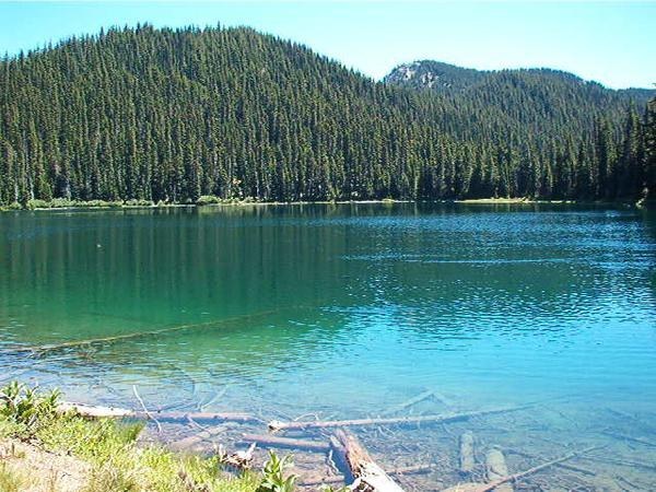
Top Lake may fall short of grandeur but makes up for it in surrounding blueberry-rich meadow. Rounding the lake on the northwest side, there is a campsite tucked up in the trees before the privy and a large area of durable surface closer to the lakeshore on the left. Expect this demure lake to be full on a warm Saturday night in the summer with families, laughter and the less-pleasant blood-sucking mosquitos.
Winding another half mile past the lake may leave you with blue-tinged fingers as you nibble berry morsels hanging from the foliage. Soon, meet up with the Pacific Crest Trail at 4575 feet, 5.8 miles from the trailhead. The Pacific Crest Trail continues 180 miles north to Canada. Luckily, you're only hiking a brief 0.7 mile on it.
The trail forgivingly climbs above a wide grassy meadow surrounding Grass Lake where a marmot or two might be sunbathing on boulders. Turn on a set of forested switchbacks where large talus spills to your left in a permanent cascade over the outlet for Pear Lake. You will hear water down below the trail but it runs inaccessibly beneath the lichen-spotted boulders.
Rest briefly at a saddle and look out to the north where majestic Glacier Peak stands on a clear day and then snake steeply once more up the crest to reach the intersection with the Meadow Creek Trail (4900 feet).
Leave the Pacific Crest Trail (PCT) here and descend 300 yards to a large open spot on the lake’s edge. It will look like a steep side trail down but keep walking past the ope area, and you will soon find an easier path back to it. For the privy, head back up the trail and a sign on a tree will be marked for the toilet where a boot path climbs up to the left next to a table-sized rock.
If you find the first campsite full with weary PCT hikers, the Meadow Creek Trail continues around the lake, gaining a scant bit of elevation as the bank steepens and then dropping again for more solitude in the northwest corner and another large campsite and privy. Much of the area around Pear Lake is fragile meadow of heather and ground blueberry.
If you're camping, be sure to pick a durable surface of soil or dry grass and camp 200 feet away from water when choosing your campsite.
WTA Pro Tip: The best vantage point for viewing the entirety of the fruit-shaped Pear Lake is to continue past the lake and up the sweeping switchbacks on the Meadow Creek Trail. Find a comfortable perch as the sun goes down and watch mountains begin to glow on the horizon. Don’t forget your headlamp for the trip back down to your campsite!

 Trailhead


