Trails for everyone, forever

Home Go Hiking Hiking Guide Pebble Creek

Alert: On Oct. 1 the federal government began a partial shutdown that will impact National Parks, National Wildlife Refuges and U.S. Forest Service lands in Washington. Here's the latest information we have for hikers and campers


Pebble Creek

Mount Rainier Area > SW - Longmire/Paradise
46.7860, -121.7360 Map & Directions
Length
4.4 miles, roundtrip
Elevation Gain
1,760 feet
Highest Point
7,180 feet
Calculated Difficulty About Calculated Difficulty
Moderate
Pebble Creek and Mount Rainier as seen from trail’s end. Photo by Wes Partch. Full-size image
  • Dogs not allowed
  • Mountain views
  • Waterfalls
  • Wildflowers/Meadows
  • Wildlife

Parking Pass/Entry Fee

National Park Pass
Saved to My Backpack

Pebble Creek is roughly the halfway point between Paradise and Camp Muir. This alpine creek marks the boundary between the front country trails that crisscross Paradise meadows and the trail-less zone of tundra above. Although not usually a destination in itself, the area is scenic, with Panorama Point close by. Continue reading

Rating
4.00 out of 5

Hiking Pebble Creek

From the Paradise parking lot, find the large stone steps and follow the Skyline Trail. Pass Glacier Vista and a notable switchback with tremendous views before coming upon the trail to Pebble Creek on your left at 1.6 miles, 6,650 feet, at another large stone staircase.

Up until this point, the verdant meadows have been teeming with marmots, deer, ptarmigan and other fauna. Tourists in flip-flops tread carefully along the wet and stony walkways. But now begins a trail of another character. Proceed with caution as signs indicate the perils of traveling unprepared in the alpine zone.

Upon the first steps of the Pebble Creek Trail, the hiker will notice the rougher and steeper grade. This allows for greater elevation gain, which will be noticeable as breathing gets more difficult. Water runs along and over the path at times, creating a somewhat muddy situation, with rocks and loose dirt composing the trail.

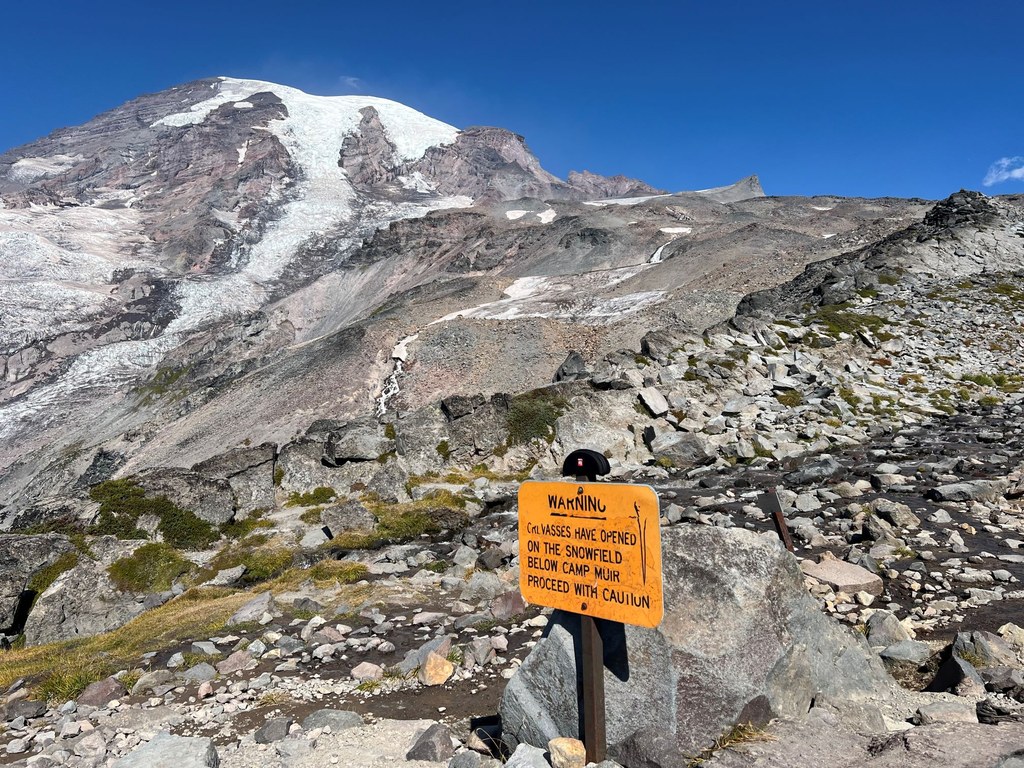
Everything above is white, and the meltwater from these snowfields creates Pebble Creek, which is still to the north at this point. A long staircase winds up to a point where a sign warns about the "Danger Zone" you are now entering. To travel here requires more risk due to inclement weather and hazardous conditions.

By this point, the trail is likely snow-covered or running with snowmelt. Stay straight at a junction surrounded by slate. To the right is Panorama Point, a worthy destination and possible addition to your return journey. In late summer, the point is swarming with tourists trying to see as many volcanoes as they can at once.

After a steep climb, the way suddenly tops out on a lateral moraine in a world of snow and ice. For a short window during late summer, the scene may be an arid wasteland with the sound of falling water coming from all around. The maintained trail ends at Pebble Creek, 7,180 feet high, 2.2 miles from the trailhead.

Traveling higher than Pebble Creek is not recommended for casual hikers; the way is snow-covered and steep. Although it is possible to day hike to Camp Muir, it is an arduous affair, to say the least. Knowledge of snow travel, including self-arrest, is advised. A sign by the creek mentions crevasses and ice falls.

As an alternate return option, descend back to the Skyline Trail and continue the clockwise loop to Paradise. Or return via the same direction and find the Deadhorse Trail, which traverses near the edge of the meadows and offers excellent views over the Nisqually Glacier. Elevation gain is minimal in both instances.

Toilet Information

  • Toilet at trailhead
  • Accessible toilet
  • Toilet has running water
  • Backcountry privy available

More information about toilets

Hike Description Written by
Wes Partch, WTA Correspondent

Pebble Creek

Map & Directions

Trailhead
Co-ordinates: 46.7860, -121.7360 Open in Google Maps

Before You Go

See weather forecast

Parking Pass/Entry Fee

National Park Pass

WTA Pro Tip: Save a copy of our directions before you leave! App-based driving directions aren't always accurate and data connections may be unreliable as you drive to the trailhead.

Getting There

From Ashford, take WA-706 east for 6 miles to the Nisqually Entrance Station at Mount Rainier National Park. Continue on Paradise Road for 17.6 more miles, a total of 23.6 miles from Ashford. Multiple parking lots for hundreds of cars allow quick access to the Henry M Jackson Visitor Center, Paradise Inn and restaurant, and plumbed bathrooms located by the trailhead. Keep in mind that summer lines to enter the park grow to wait times longer than 1 hour, and the parking lots fill up early.

More Hike Details

Trailhead

Mount Rainier Area > SW - Longmire/Paradise

Pebble Creek (#N/A)

Mount Rainier National Park

Guidebooks & Maps

50 Hikes in Mount Rainier National Park - Ira Spring and Harvey Manning (The Mountaineers)

Green Trails Maps No. 270S - Paradise

Buy the Green Trails Paradise No. 270S map

Buy the Green Trails Mt Rainier East No. 270 map

You can improve or add to this guidebook entry!

Pebble Creek

27 Trip Reports

Hiked here recently?

Submit a trip report!
 
Trip Reports