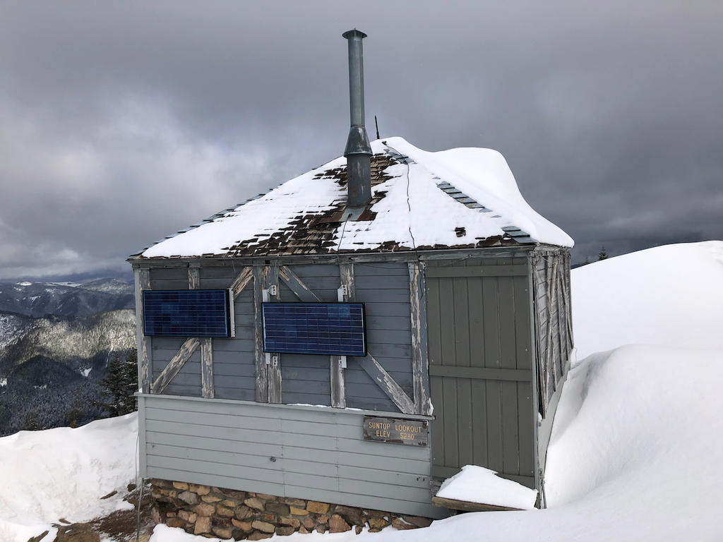
You are here: Home Find a Hike Hiking Guide Sun Top Snowshoe

Sun Top Snowshoe

» REI » Amazon

A portion of all book sales from the links above benefits WTA and helps protect and maintain our trails.

The route to the top of Sun Top is often groomed for cross-country skiers, but snowshoers will still enjoy this trek. After all, the views are just as spectacular, and the winter landscape just as pretty, even when the trail has been leveled for skiers. Just stick to the edges of the road to avoid tromping on skiers' tracks, and take advantage of any opportunity to climb off the road and cross open meadows for maximum snowshoeing fun.
Attaining the summit of Sun Top requires considerable energy, but the workout is well rewarded with unmatched views of the country northwest of Mount Rainier. The White River valley stretches below the mountain, and Mount Rainier towers above. The lower section of the route is sometimes visited by the White River elk herd, so keep an eye out for the big beasts. This is also prime cougar country (due, in large part, to the presence of the elk). Seeing one of the big cats is a pleasure. Cougars pose little threat to adult humans, although kids shouldn't be allowed to run ahead. The odds of seeing a mountain lion are extremely low, but a couple lucky snowshoers have excitedly reported seeing the tawny cats streaking away from the road when the elk are nearby.

The route to the summit follows FR 7315. Snowshoe up the only road leaving the Sno-Park, pass the gate, and in a couple hundred feet, turn left up FR 7315. The road climbs steadily to the summit, and because of the frequent clearcuts encountered along the hike there are ample opportunities to stop, rest, and savor the scenery spread out before you. As the trail climbs the ridgeline, look down into the wide White River valley and the narrower, darker Huckleberry Creek basin. The best place to find elk is along the lower clearcuts, although from the higher clearcuts it's possible to look down into the open meadows along the rivers. Using a good pair of binoculars, scan the river meadows for the large herds that live in the White River drainage.

A few spur roads are found along the way, and these make nice diversions from the well-traveled main road. Snowshoe out along them for a new view, and then angle up through the trees and meadows to rejoin the main trail. By climbing straight through the larger clearcuts rather than following the looping road, you can save nearly a mile and enjoy some untracked snow.

Following the road all the way, it is 5 miles to a high bench below the summit of Sun Top. The summit approach requires crossing some serious avalanche slopes, so attempt the top only when conditions are stable and avalanche dangers are reported as low. For the best views south to Rainier, angle southwest around the bench about 400 yards to an open view of Mount Rainier and all the lesser peaks between.

Author’s Rating: More Difficult
Some previous snowshoe experience helpful. Some winter survival skills recommended (basic knowledge of avalanche evaluation, emergency shelter construction, etc.). Elevation gain is usually less than 1000 feet with a gradual slope.
Driving Directions:

To get there, from Enumclaw drive east on State Route 410 for 24 miles and turn right (south) onto Forest Road 73 (Huckleberry Creek Road). Drive south 1.5 miles to the Sun Top Sno-Park.

Improve or add to this guidebook entry

Note: the description and driving directions for this Mountaineers Books entry are copyrighted and can't be changed.

Recent Trip Reports

Hiked here recently? Submit a trip report!
There are 6 trip reports for this hike. See all trip reports for this hike.
Sun Top Snowshoe — Feb 15, 2013 — TTtripleHhiker
Day hike
Issues: Blowdowns | Water on trail | Snow on trail
Expand report text Hide report text
This is quite the hike! We knew it would be long and steep and we got all we were expecting. Start...
This is quite the hike! We knew it would be long and steep and we got all we were expecting.
Starts off from the easy to get to snow park going up and doesn't stop. But I must say it is worth the trip. Mostly booted it up since we got an early start but at 3.6 miles we put our snowshoes on when the snow was not as packed down. Only flat spot in the whole hike is what seems to be the summer parking lot and from there we decided on taking the actual marked trail to the left as it seemed the most traveled but beware as it took us straight up! The road would have been easier! But it was an adventure! Awesome sunny day and amazing views up top seemed like the smoke alarm in the lookout was going dead could hear a beeping inside. The way down was rough! we took the road down the whole way from the top as the slope we came up was steep. Loooong road hike and the snow was very soft we were So tired so happy to see the car at the end but really great day regardless! My GPS clocked us at a little over 11 miles today and over 4000 ft of elevation gained.
 Oh and we got to see about 3 elk leaving on FR 73 they are huuuge!
Read full report with photos
Sun Top Snowshoe — Nov 16, 2012 — Wendy W
Day hike
Issues: Snow on trail
Expand report text Hide report text
We love driving the forest roads almost as much as hiking so we had to see how far up we could drive...
We love driving the forest roads almost as much as hiking so we had to see how far up we could drive. Snow starts at about mile 3 and gets deeper as you go up. Our Subaru took us all the way up to the parking area just below the closed gate at mile 5. The snow was several inches deep there.

We walked the mile up the road up to the lookout in pretty falling snow. I wore micro spikes but almost wanted my snowshoes in the deeper snow. It got up to about ten inches in places. The wind was really blowing at the top and clouds blocked the view of Mount Rainier but it was neat to be there in the snow.

Read full report with photos
Sun Top Snowshoe — Nov 15, 2012 — weflybye
Day hike
Issues: Snow on trail
Expand report text Hide report text
We hit snow at mile marker 3 and put on our micro-spikes. Carried up our snowshoes but never used th...
We hit snow at mile marker 3 and put on our micro-spikes. Carried up our snowshoes but never used them. We could have put them on for a short period but chose to posthole through snow for about half a mile instead. Beautiful views of Mount Rainier at the top. GPS showed total miles = 11 and total elevation gain was 3100 feet. We started from the lower parking area. Great hike - perfect weather. As always very windy at the top so bring lots of layers!
Read full report with photos
Sun Top Snowshoe — Apr 22, 2012 — curious george
Day hike
Issues: Snow on trail | Road to trailhead inaccessible
Expand report text Hide report text
The forecast called for 73 degrees and sunny! so i decided to load up the 4runner for my first s...
    The forecast called for 73 degrees and sunny! so i decided to load up the 4runner for my first snowshoe trek. At 1.5 miles up the 7315 service road i ran into snow and decide this was a good spot to start. 3.5 miles later i was at the trailhead, i didnt see any boundery markers so had to bushwack the last 1/2 mile to the top. 360 degree views from the top (north cascades, olympics, chinook pass). spent a hour taking in the mountain and decided to head back down.
Read full report with photos
Sun Top Snowshoe — Dec 31, 2011 — weflybye
Snowshoe/XC Ski
Issues: Snow on trail
Expand report text Hide report text
Gate closed at lower parking area. Snowshoed from there. Snow was powdery and had to break trail b...
Gate closed at lower parking area. Snowshoed from there. Snow was powdery and had to break trail but the day was beautiful and sunny. Had lunch at the lookout tower. Really worth the work to get to the top and see the views! Don't forget your Snowpark pass - it is required or you get a ticket.
Read full report with photos
Sun Top Snowshoe — Apr 08, 2011 — Eric Jain
Snowshoe/XC Ski
Issues: Blowdowns | Snow on trail
Expand report text Hide report text
The Sno-Park was clear of snow (and other cars) when I arrived at 9am. Put on snowshoes about one...
The Sno-Park was clear of snow (and other cars) when I arrived at 9am.

Put on snowshoes about one mile up the road. There were no prior tracks, apart from some tracks left by elk and rabbits. The snow varied from soft to wet, but for the most part didn't stick to the snowshoes.

Left the road at about 4,560ft to shortcut a long hairpin turn. Crossed the road above and headed up through the trees along the ridge south of Sun Top, to avoid any steep, open slopes.

Great views from the top (and from the top only).

Photos: http://picasaweb.google.com/eric.jain/SunTopApril2011
Tracklog: http://connect.garmin.com/activity/77992146

Read full report with photos
sun top mountain- hiking queen.jpg
Dark skis approaching on Sun Top, photo taken by HikingQueen.
Location
Mt. Rainier
Mount Baker-Snoqualmie National Forest, Snoqualmie Ranger District
Statistics
Roundtrip 10.0 miles
Elevation Gain 3000 ft
Highest Point 5280 ft
Features
Summits
User info
Sno-Park pass required
Guidebooks & Maps
Green Trails: Greenwater No. 238

Improve or add to this guidebook entry

Note: the description and driving directions for this Mountaineers Books entry are copyrighted and can't be changed.

Map it
Red MarkerSun Top Snowshoe
47.0371404558 -121.595649719
(47.0371, -121.5956) Open in new window
Document Actions
  • Email this page
  • Print this
  • Share
Get the Guidebooks

Mountaineers three booksSelect content from The Mountaineers Books' guidebooks is featured in this Hiking Guide. Sales of the books from this website help protect and maintain trails.

> Shop Now

More hikes » Hike of the Week
Dog Mountain (May 23)

Dog Mountain

South Cascades

Head to Dog Mountain for Columbia River Gorge views and an explosion of wildflowers. Eager to get in shape for summer? Head straight up the mountain on the northern side. Take the slow and steady eastern flank trail to stop and smell the flowers. (See if you can spot recent work by WTA trail crews.)

Get Trail News

Subscribe to our free email newsletter for hiking news, events, gear reviews and more.

link