
The Whittier Ridge Trail has been called “The Scariest Hike in Southwest Washington”. It has narrow ledges, sheer drop-offs, and rocky scrambles requiring the use of your hands. The route is not really a trail; it demands your focus, attention, and route-finding skills for two full miles. In wet or icy conditions, it may be impassable. Exposure is extreme; don’t attempt this in foul weather.
If you are camped nearby (by permit only), the loop itself is 8.5 miles. If not, the stem of the “lollipop” begins at the Norway Pass trailhead. This guide describes a counter-clockwise loop. The advantages are a reliable water source, and an easier way to find the reroute around a treacherous section at the north end of the Whittier Ridge Trail. The disadvantage is a longer return route if you are forced to turn around.
Head northwest on the Boundary Trail 1.1 miles to a junction with the Independence Ridge Trail, then go right one mile to Norway Pass. Continue straight 0.8 mile to a junction with the Lakes Trail and the beginning of the loop, at 2.9 miles.
Take the Lakes Trail to the right, up and over Bear Pass at 4950 feet, then drop quickly behind a ridge that harbors shade, keeping the lupine blooming into late August. At 0.5 mile, Grizzly Lake pops into view suddenly. Drop to the shore of the log-littered lake and cross the outlet, then climb gently through salmonberry and young alder, passing a small stream at 1.3 miles. At 2.2 miles, 4450 feet, a sign announces Obscurity Lake. At 2.3 miles, cross the outlet of Boot Lake on a footlog to Obscurity Camp. Continue the pleasant, although sometimes brushy, path from lake to lake.
Between the pan and the handle of Panhandle Lake at 3.3 miles is the lake's inlet stream, coming from Shovel Lake above. This is your last water before the Ridge trail. Fill up, then climb 600 feet in one mile, passing a side trail that leads down to Shovel Lake. Traverse to Pleasant Pass at 4.7 miles, 5190 feet, and the junction with the Whittier Ridge Trail.
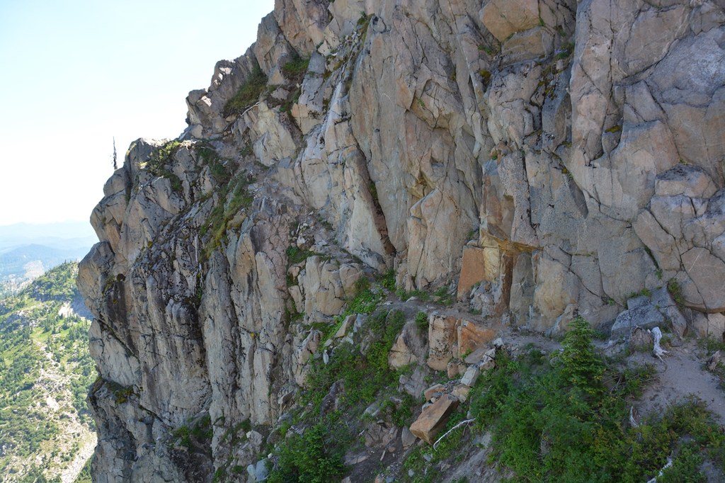
Just a tenth of a mile along the Whittier Ridge Trail, begin looking for the crucial correct path. Where the trail appears to continue straight to the southwest, look for a switchback to your left that ascends a small talus slope heading east. If you reach an impassable slide area, retrace your steps. The correct route is steep, circling out to the east before climbing to the top of the ridge due south of you.
Once on top, there is no definite trail. You must route-find your way for nearly two miles, roughly following the ridge. Even a seemingly obvious path is not necessarily the correct route. (This is especially true 0.2 mile east of the Mount Whittier summit.)
Scramble little ups and downs constantly to negotiate your way. Sometimes you must skirt drop-offs of several hundred feet. The views are outstanding in clear weather. But you will need to be more attentive to your footing than to the views. In some places, the route is so narrow that you want to be carrying nothing wider than a day pack. And there is no water along the ridgeline. Expect this section to take you 2 to 3 hours, depending on your skills.
The Whittier Ridge Trail meets up with the Boundary Trail at 6.7 miles from your trailhead. Go east, passing Bear Camp at 7.3 miles, where you might refill on water, and close the loop back at the camp, making it an 8.5 mile loop (11.4 if you started from the trailhead at the road). Continuing to the trailhead, it's a 2.9 more miles along the stem of the lollipop, back to the trailhead, making it 14.3 miles total.
Whittier Ridge-Lakes Loop

-
 Length
- 14.3 miles, roundtrip
-
 Elevation Gain
- 3,800 feet
-
 Highest Point
- 5,840 feet
Parking Pass/Entry Fee
Northwest Forest Pass
“Most Difficult”. If you can accept and safely navigate what that means, the Whittier Ridge Trail offers you an airy and ruggedly scenic connection between the Boundary Trail and the Lakes Trail, for an 8.5-mile loop, part of a 14.3-mile “lollipop” day hike.
Continue reading
Hiking Whittier Ridge-Lakes Loop
Map & Directions
 Trailhead
Before You Go
Parking Pass/Entry Fee
Northwest Forest PassWTA Pro Tip: Save a copy of our directions before you leave! App-based driving directions aren't always accurate and data connections may be unreliable as you drive to the trailhead.
Getting There
From the town of Randle, drive south for 20 miles on what begins as State Route 131 and in a few miles becomes Forest Road 25. Turn right from FR-25 onto FR 99 and travel 9 miles, then turn right on FR 26 and continue one mile to the trailhead. The parking lot has two vault toilets and room for about 35 vehicles. There is no water available.


