

Boulder Lake is a brilliant, azure gem set deep within a stunning cirque of metamorphic cliffs, but to reach it you will need perseverance. The terrain is steep, and the trail is never more than a way path. In some places the tread disappears entirely, and the talus slopes can send hikers astray. Route finding skills are necessary, as is the ability to scramble safely up the final class 2 boulder field. In other words, this is not a walk in the park.
Start by following the deceivingly well-beaten tread past an old signpost. The trees are second growth with remnant large stumps from a once greater forest. Soon, the trail begins its ever upward climb, gaining steep ground by using tree roots that make tricky footing. To complicate the matter the tread is often muddy.
The trail zigzags between logs and into old growth where the inviting Tenas Creek spills over moss covered logs beneath a lush canopy of mature hemlock and fir. Stay left to continue on the trail. After a long uphill push the creek again commands attention at 1.0 mile where a twin waterfall and relatively flat environs make a good rest stop.
From here the trail gets narrower, rockier, and steeper. Foot holds cut into roots and rocks lead the way to the Glacier Peak Wilderness sign, after which another short reprieve beckons the hiker again to the bank of Tenas Creek. The water is now calm and crystal clear, meandering in wide ribbons through a lovely bottomland. Stay left to resume the trail to Boulder Lake.
At 2.0 miles the trail climbs steeply out of the forest and into an enormous and verdant avalanche slope littered with boulder fields between island stands of young Alaska cedar. The way is rough and follows cairns across the boulders. The creek can be seen tumbling down in scenic cascades and pools below. There is no shade but the scenery is breathtaking.
The headwall now looms closer and a noisy waterfall marks the outlet of Boulder Lake. Follow cairns and tread to Tenas Creek and cross it, heading away from the waterfall to a second, dry notch full of boulders. This is the approach to Boulder Lake, and it is a true scramble with vertical exposure that might be uncomfortable for some. The way is just simply up.
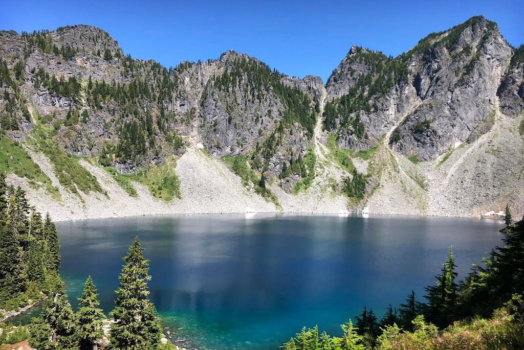
Once atop the boulders, faint paths coalesce into a well beaten and obvious trail again. The trail stays left of a small bay and enters a pleasant camp area with several sites and a privy nearby. Now the pristine waters of Boulder Lake come into full view. On still days the cliffs lay mirrored in the blue depths, the day’s end bringing an alpenglow show that lasts long after camp is dark.
Although the camp area is relatively flat and accommodating, the shoreline of Boulder Lake is hazardous to follow due to the steeply sloped boulders fields and cliff bands along its edge. With little space to roam, the outlet area is the best spot for pitching your tent and enjoying an overnight stay. Just bring bug spray to outlast the mosquitoes.
 Trailhead


