

Take a hike on a trail more-travelled and a second trail less-traveled. Be patient with the summer dust and horses on the first 2.5 miles, then enjoy the less traveled, long traverse high on Eightmile Ridge with views across and down the Eightmile Creek valley. Drop slightly into a wide pass and then climb steeply through a larch grove, then a talus slope to the top of Burch Mountain. The former lookout site has the expected spectacular 360-degree view.
Do note that the 2017 Diamond Creek Fire, started by an unattended campfire devastated this area. Most of the forest burned, leaving more open views through the blackened trunks that remain standing and much less shade. Fortunately, most of the flowers survived, so the understory is very colorful in the late spring and summer.
From the trailhead, Burch Mountain is one mile away (by line-of-sight) to the northeast and 3010 feet above you. Luckily, a trail will get you there on a much nicer grade than bushwhacking for the top. Set out on that trail, leaving from the trailhead that the Larch Creek #502 and Hidden Lakes #477 trails share. Stay on this route for the first 0.3 mile, then at the junction, take the right branch for Larch Creek Trail 502 toward Billy Goat Pass. Save the long hike to Hidden Lakes for a multiday backpack trip.
The next 0.8 mile of climbing crosses mine tailings as it passes a mine entrance above the trail and continues with broad switchbacks, the views ever-improving across to Eightmile Pass and Lost Peak. Mostly, this section is hot in summer on the south facing slope, with minimal shade. The summer flowers provide color and a distraction.
A surviving pocket of trees provides shade for the next 0.4 mile of switchbacks, then it returns to the blackened forest for another 0.3 mile.
It crosses a stream bed, usually dry by mid-summer, but don’t panic. The spring that feeds it keeps flowing into the early fall. The trail stays close to the streambed and eventually you will hear the sound of running water, the last reliable water on this trip. On a hot day, a face-splash makes a refreshing break before the last half-mile push to Billy Goat Pass, elevation 6660 feet and 2.5 miles from the trailhead.
About 70 yards beyond the pass is the Burch Mountain Trail on the right. Only an unreadable chunk of charred wood bolted to a tree remains from the Burch Mountain Trail sign. The first 0.2 mile of the trail wanders up a meadowed draw and then back into the blackened forest just before a sharp left-turn that signals the start of a 0.3 mile switchbacked climb of 400 feet.
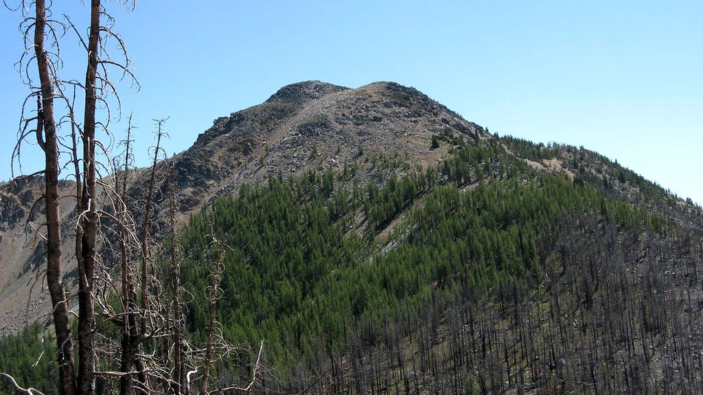
From the top of the switchbacks, the next 0.6 mile is a gradual climb across the nearly treeless hillside, passing above and across scree and gravel chutes and ducking behind large rock outcroppings. The wide views include those down the 40 degree slope the trail is crossing. Near the end of the traverse, Burch Mountain comes into view, with a cloak of larches that glow golden in the fall.
Over the next 0.3 mile, the trail descends 250 feet into a broad pass and continues across it (southeast) into the larch forest. The trail can be very faint in the pass, which can hold snow to mid-July.
Once across the pass and into the surviving forest, the last push to the top begins. In the forest, the trail has a few switchbacks as it climbs for 0.2 mile, toward the last large tree on the slope. Where the trail goes around (above) and left onto the talus slope for the last steep climb. A few cairns help mark the 0.3-mile way up, eventually reaching a sand/gravel area that leads to a small pass.
In the pass is an unmarked junction. To the left is the top of Burch Mountain, and straight up is a continuation of the Burch Mountain Trail going down the alternative ascent route, Burch Mountain via Falls Creek.
At the top, take in the view southwest to Eightmile and Big Craggy peaks, or west down to Eightmile Pass, the route to Hidden Lakes, or North down the Drake Creek valley and beyond into the Pasayten Wilderness. For those planning a waterless camp, a small, somewhat lumpy tent platform is to the east of the lookout site.
Some of the cables, cable anchors, and post foundations remain from the lookout. Other than that, there are lots of nails and glass from the last lookout, built in 1934 and destroyed by an accidental fire in 1957.
 Trailhead


